Publications
, “From Vision to Reality: Implementing NOAA's Re-envisioned Hydrographic Survey Specifications”, Canadian Hydrographic Conference. St. John's, Newfoundland, Canada, 2024.
, “HydrOffice: Past, Present, and Future”, NOAA OCS Field Procedures Workshop. p. Portland, OR, 2018.
, “Hydrographic Survey Validation and Chart Adequacy Assessment Using Automated Solutions”, U.S. Hydro 2019. Biloxi, MS, USA, 2019. USHydro2019_Masetti_et_al_Hydrographic_Survey_Validation_and_Chart_Adequacy_Assessment.pdf (882.67 KB)
, “Pydro and HydrOffice”, Effective Seabed Mapping Workflow. Canberra, ACT, Australia, 2019.
, “Research-driven Tools for Ocean Mappers”, Hydro International, vol. 22, 1. GeoMares Publishing, pp. 29-33, 2018. hydro-international-2018-1-2-research-driven-tools-for-ocean-mappers.pdf (1.05 MB)
, “Opening the Black Boxes in Ocean Mapping: Design and Implementation of the HydrOffice Framework”, AMSA 2019. p. Freemantle, WA, Australia, 2019.
, “Variable Resolution Bathymetric-Gridding Technology for Nautical Charting: Case Study CHRT Data”, U.S. Hydrographic Conference (US HYDRO). The Hydrographic Society of America, New Orleans, LA, USA, 2013.
, “Development of an Uncertainty Propagation Equation for Scalar Fields”, Marine Geodesy, vol. 40, 5. Taylor & Francis Group, pp. 341-360, 2017. calder-marine-geodesy-2017.pdf (2.27 MB)
, “Effective Automated Procedures for Hydrographic Data Review”, Geomatics, vol. 2(3). MDPI, Basel, Switzerland, pp. 338-354, 2022.
, “Hydrographic Survey Validation and Chart Adequacy Assessment Using Automated Solutions”, U.S. Hydro 2019. Biloxi, MS, USA, 2019. USHydro2019_Masetti_et_al_Hydrographic_Survey_Validation_and_Chart_Adequacy_Assessment.pdf (882.67 KB)
, “Nautical Cartography Competences and Their Effect to the Realisation of a Worldwide Electronic Navigational Charts Database, the Performance of ECDIS and the Fulfilment of IMO Chart Carriage Requirement”, Marine Policy, vol. 75. Elsevier, pp. 29-40, 2017.
, “Use (and Potential Abuse) of Uncertainty in Hydrography”, 6th International Conference on High-Resolution Survey in Shallow Water. Wellington, New Zealand, 2012.
, “Applications of Sonar Detection Uncertainty for Survey Quality Control and Data Processing”, Shallow Survey 2018. p. St. John's, NL, Canada, 2018. Masetti_SS2018_Sonar_Detection_Uncertainty_abstract.pdf (409.17 KB)
, “Industry Discovery for Ocean Mapping Workflow Associated Challenges”, 2021 US Hydro Conference. p. Online, 2021.
, “On Risk-Based Expression of Hydrographic Uncertainty”, Marine Geodesy, vol. 38(2). Taylor & Francis, pp. 99-127, 2015.
, “Hydrographic Geospatial Data Standards”, in The Geographic Information Science & Technology Body of Knowledge, 2nd Quarter 2022 nd ed., 2022.
, “Label-Based Generalization of Bathymetry Data for Hydrographic Sounding Selection”, Cartography and Geographic Information Science, vol. 49(4). Taylor & Francis, 2022.
, “The Viability of Crowdsourced Bathymetry for Authoritative Use”, U.S. Hydrographic Conference (US HYDRO). The Hydrographic Society of America, Biloxi, MS, 2019.
, “Using Free and Open-Source Software in Ocean Mapping: Case Study of the Spanish EEZ project near the Canary Islands”, 2021 US Hydro Conference. p. Online, 2021.
, “A Low Cost System for Autonomous Surface Vehicle based Hydrographic Survey”, U.S. Hydrographic Conference 2015. 2015. USHydro_2015_Manda_Final.pdf (1.26 MB)
, “A procedure for developing an acceptance test for airborne bathymetric lidar data application to NOAA charts in shallow waters”, National Oceanic and Atmospheric Administration (NOAA), National Ocean Survey (NOS), Silver Spring, MD, 2013.
, “Characterizing Free and Open-Source Tools for Ocean-Mapping”, 6th Hydrographic Engineering Conference. Lisbon, Portugal, pp. 53-56, 2020. Cordero_Kastrisios_2020_FOSS4G_Procceedings.pdf (2.06 MB)
, “Resolution Determination through Level of Aggregation Analysis”, U.S. Hydrographic Conference (US HYDRO). The Hydrographic Society of America, Biloxi, MS, 2019. Calder_USHydro19_LevelOfAggregationAnalysis.pdf (815.13 KB)
, “Exploring Ancillary Parameters for Quantifying Interpolation Uncertainty in Digital Bathymetric Models”, Marine Geodesy. Taylor & Francis Group, 2024.
, “Sounding Labels and Scale for Bathymetric Data Generalization in Nautical Cartography”, 2021 US Hydro Conference. p. Online, 2021.
, “Depth Adaptive Hydrographic Survey Behavior for Autonomous Surface Vessels”, IEEE/MTS Oceans '15. IEEE, National Harbor, MD, 2015. IEEEOceans_2015_Abstract_Manda.pdf (386.24 KB)
, “Chart Features, Data Quality, and Scale in Cartographic Sounding Selection from Composite Bathymetric Data”, Geo-spatial Information Science. Taylor & Francis, 2023.
, “EMODNET Bathymetry Services and Free and Open-Source Software in Support of Hydrographic Survey Procedures”, EMODnet Open Conference. p. Online, 2021.
, “EMODNET Bathymetry Services and Free and Open-Source Software in Support of Hydrographic Survey Procedures”, EMODnet Open Conference. p. Online, 2021.
, “Using Free and Open-Source Software in Ocean Mapping: Case Study of the Spanish EEZ project near the Canary Islands”, 2021 US Hydro Conference. p. Online, 2021.
, “Marine Spatial Data Infrastructure”, in The Geographic Information Science & Technology Body of Knowledge, 2022.
, “Geology and Fluid Discharge at Dorado Outcrop, a Low Temperature Ridge-Flank Hydrothermal System”, Geochemistry, Geophysics, Geosystems, vol. 20(1). AGUPubs, pp. 487-504, 2019.
, “Clusters of Deep-Sea Egg-Brooding Octopods Associated with Warm Fluid Discharge: An Ill-Fated Fragment of a Larger, Discrete Population?”, Deep Sea Research Part I Oceanographic Research Papers, vol. 135. ELSEVIER, pp. 1-8, 2018. Hartwell et al 2018.pdf (4.44 MB)
, “Signs of Recent Volcanism and Hydrothermal Activity Along the Eastern Segment of the Galapagos Spreading Center”, 2016 Fall Meeting, American Geophysical Union (AGU). American Geophysical Union , San Francisco, CA, p. San Francisco, CA, 2016.
, “Subseafloor Cross‐Hole Tracer Experiment Reveals Hydrologic Properties, Heterogeneities, and Reactions in Slow‐Spreading Oceanic Crust”, Geochemistry, Geophysics, Geosystems, vol. 21(1). AGUpubs, pp. 1-15, 2020.
, “Exploration of Hydrothermal Vents Along the Galapagos Spreading Center”, Oceanography, vol. 29, No.1, Supplement. The Oceanography Society, pp. 35-7, 2016. mayer-oceanography-v29-no1-galapagos.pdf (692.56 KB)
, “Global-Local-Comparison Method: Understanding Marine Mammal Spatial Behavior by Applying Spatial Statistics and Hypothesis Testing to Passive Acoustic Data”, Frontiers in Marine Science, vol. 8:625322. 2021.
, “Tracking the Spatiotemporal Variability of the Oxic–Anoxic Interface in the Baltic Sea with Broadband Acoustics”, ICES Journal of Marine Science. 2020.
, “Surficial Geology Mapping of the Arctic Ocean: Using Subbottom Profiling and Multibeam Echosounding Data Sets to Constrain the Subsea North of 64° as a Layer for the IBCAO”, 2016 Fall Meeting, American Geophysical Union. p. San Francisco, CA, 2016.
, “The International Bathymetric Chart of the Arctic Ocean (IBCAO) version 3.0”, Geophysical Research Letters, vol. 39. 2012. Jakobsson-et-al-2012-GRL.pdf (778.6 KB)
, “Nautical Cartography Competences and Their Effect to the Realisation of a Worldwide Electronic Navigational Charts Database, the Performance of ECDIS and the Fulfilment of IMO Chart Carriage Requirement”, Marine Policy, vol. 75. Elsevier, pp. 29-40, 2017.
, “On the Existence of an East-Siberian-Chukchi Ice Sheet: New Insights from the SWERUS-C3 Expedition 2014”, 2015 Fall Meeting, American Geophysical Union (AGU). San Francisco, CA, 2015.
, “Evidence for an Ice Shelf Covering the Central Arctic Ocean During the Penultimate Glaciation”, Nature Communications, vol. 7. Macmillan Publishers Ltd., 2016. mayer-natcomm-01-2016.pdf (3.3 MB)
, “Visualization of Nautical Information (VONI) Workshop 2017”, International Hydrographic Organization, Monaco, 2017. NIPWG 3-39.1 VONI_workshop.pdf (161.31 KB)
, “NIPWG7-8.1 The History and Status of S-126 Marine Physical Environment”, International Hydrographic Organization (IHO), Tallinn, Estonia, 2019. NIPWG7_2019_08.1_EN_S-126_History_Status.pdf (254.96 KB)
, “NIPWG6-5.3 NOAA's NPB progress on transitioning from paper products to S-100 products (progress on interoperability between CP and ENC_”, International Hydrographic Organization (IHO), Rostock, Germany, 2019. NIPWG6_2019_5.3_EN_UNH-NSD_data-centric_workshop_report.pdf (390.21 KB)
, “NIPWG7-48.2_Creation and storage of S-127 (Marine Traffic Management) for US Waters”, International Hydrographic Organization (IHO), Tallinn, Estonia, 2019. NIPWG7_2019_48.2_EN_Creation and storage of S-127 for US waters.pdf (215.06 KB)
, “NIPWG6-08.1 - Status report on the development of S-126: Marine Physical Environment”, International Hydrographic Organization (IHO), Rostock, Germany, 2019. NIPWG6_2019_08.1_EN_Status report S-126_v1.pdf (417.56 KB)
, “NIPWG6-35.1 S-125 Navigational Services status update”, International Hydrographic Organization (IHO), Rostock, Germany, 2019. NIPWG6_2019_35.1_EN_S-125_status_report_clean_v1.pdf (112.92 KB)
, “Efforts for Developing Symbology for New S-1xx PS”, IHO Nautical Cartography Working Group (NCWG), Wollongong, Australia, 2022.
, “User-Centered Design of Nautical Chart Symbols”, 2023 US Hydro Conference. p. Mobile, AL, 2023.
, “Potentially Polluting Marine Sites GeoDB: An S-100 Geospatial Database as an Effective Contribution to the Protection of the Marine Environment”, International Hydrographic Review, vol. 8. International Hydrographic Bureau, Monaco, Monaco Cedex, Monaco, pp. 27-40, 2012. PPMS_GeoDB_IHR_2012.pdf (1.41 MB)
, “A Geo-database for Potentially Polluting Marine Sites and Associated Risk Index”, University of New Hampshire, Durham, NH, 2012. masetti-giuseppe-thesis.pdf (14.38 MB)
, “Marine protected areas and electronic navigational charts: legal foundation, mapping methods, IHO S‑122 portrayal, and advanced navigation services”, Euro-Mediterranean Journal for Environmental Integration, vol. 8. Springer, 2023.
, “Marine protected areas and electronic navigational charts: legal foundation, mapping methods, IHO S‑122 portrayal, and advanced navigation services”, Euro-Mediterranean Journal for Environmental Integration, vol. 8. Springer, 2023.
, “Optimal Image Blending for Underwater Mosaics”, Oceans 2006. IEEE, Boston, MA, 2006. Gu_IEEE_2006_Optimal_image_blending_for_underwater_mosaics.jpg (952.33 KB)
, “Global and Local Magnitude and Spatial Pattern of Uncertainty from Geographically Adaptive Empirical and Machine Learning Satellite Derived Bathymetry Models”, GIScience and Remote Sensing, vol. 61(1). p. 2297549, 2024. Lowell_Rzhanov_2023_GlblAndLocalSpatialUncertPatternFromGeogAdaptiveSDBModels.pdf (8.27 MB)
, “Detection of Deep Water Benthic Macroalgae Using Image-based Classification Techniques on Multibeam Backscatter at Cashes Ledge, Gulf of Maine, USA”, Estuarine, Coastal and Shelf Science, vol. 91. Elsevier, New York, NY, USA, pp. 87-101, 2011.
, “Machine Learning Strategies for Enhancing Bathymetry Extraction from Imbalanced Lidar Point Clouds”, Oceans '19. IEEE, Seattle, WA, 2019.
, “Machine Learning Strategies for Enhancing Bathymetry Extraction from Imbalanced Lidar Point Clouds”, Oceans 2019. IEEE, Seattle, WA, 2019. Oceans2019_KLowell_BCalder_190523-005.pdf (741.12 KB)
, “The Contribution of Marine Cartographers to the Efficient Management of Immigration Flows (In Greek with English Abstract)”, 14th Hellenic Cartographic Conference. Hellenic Cartographic Society, Thessaloniki, Greece, 2016. Kastrisios_Tsoulos_2016_TheContribution_of_MarineCartographers_to_theEfficientManagement_of_ImmigrationFlows_InGreekEnglishAbstract.pdf (955.58 KB)
, “A Framework to Quantify Uncertainties of Seafloor Backscatter from Swath Mapping Echosounders”, Marine Geophysical Research, vol. 39(1-2). Springer, pp. 151-168, 2018.
, “Is Low Frequency Ocean Sound Increasing Globally?”, Journal of the Acoustical Society of America, vol. 139. Acoustical Society of America, pp. 501-511, 2016.
, “Bearing Stake 1977 Revisited: An understanding of Ambient Sound Sources in the Indian Ocean”, Journal of the Acoustical Society of America - Express Letters, vol. 148, No. 4. pp. EL320-EL325, 2020.
, “Decadal Trends in Indian Ocean Ambient Sound”, Journal of the Acoustical Society of America, vol. 134. Acoustical Society of America, pp. 3464-3475, 2013.
, “Toward cyberinfrastructure to facilitate collaboration and reproducibility for marine integrated ecosystem assessments”, Earth Science Informatics, vol. 10. Springer, p. 13, 2016. art%3A10.1007%2Fs12145-016-0280-4.pdf (2.49 MB)
, “Performance Evaluation of the Velodyne VLP-16 System for Feature-Surface Surveying”, 2016 Canadian Hydrographic Conference. Canadian Hydrographic Association, Halifax, Nova Scotia, Canada, 2016.
, “Measurement of Dynamic Biases in Hydrographic Surveying Using an Industrial Laser Scanner”, 2016 Canadian Hydrographic Conference. Canadian Hydrographic Association, Halifax, Nova Scotia, Canada, 2016. Kidd_et_al_CHC2016_proceeding_paper.pdf (1004.89 KB)
, “Using a Cruise Report to Generate XML Metadata”, IEEE/MTS Oceans. IEEE/MTS, Hampton Roads, VA, 2012. Sullivan_2012_Oceans_UsingCruiseReport.pdf (815.41 KB)
, “Are Manatees Modifying Their Vocalizations to Compensate for Noise?”, Journal of the Acoustical Society of America, 2006.
, “Subtidal Flow Structure in Tidally Modulated Inlets”, Coastal Dynamics 2013, vol. 1. ASCE, Plymouth, England, United Kingdom, 2013. 130_lippmann_thomas.pdf (7.65 MB)
, “Observations of the Vertical Structure of Tidal Currents in Two Inlets”, Journal of Coastal Research, vol. 65, Special Issue. pp. 2029-2034, 2013. ICS2013_lippmann_revised2.pdf (4.17 MB)
, “A procedure for developing an acceptance test for airborne bathymetric lidar data application to NOAA charts in shallow waters”, National Oceanic and Atmospheric Administration (NOAA), National Ocean Survey (NOS), Silver Spring, MD, 2013.
, “Multi-touch 3D Positioning with the Pantograph Technique”, ACM SIGGRAPH Symposium on Interactive 3D Graphics and Games, vol. 13. ACM, Montreal, Quebec, Canada, 2019. Butkiewicz-Pantograph-i3D-2019.pdf (688.01 KB)
, “Evaluating Outside Source Interferometric Data for Chart Updates”, 2016 Canadian Hydrographic Conference. Canadian Hydrographic Association, Halifax, Nova Scotia, Canada, 2016. CHC_Schmidt_2016_final.pdf (2.9 MB)
, “Mapping and quantifying morphological parameters of eelgrass (Zostera marina) beds in eastern Cape Cod Bay, MA using an interferometric sonar system”, Coastal and Estuarine Research Federation Meeting, Daytona Beach, FL. 2011.
, “The Effect of Internal Wave-Related Features on Synthetic Aperture Sonar”, IEEE Journal of Oceanic Engineering, vol. 40, No. 3. IEEE, pp. 621-631, 2015. IEEE_JOE_vol_40_pages_621-631.pdf (2.88 MB)
, “Design of a Wireless, Inexpensive Ocean of Things System for Volunteer Bathymetry”, IEEE Internet of Things Journal. IEEE, 2023.
, “Optimizing Resolution and Uncertainty in Bathymetric Sonar Systems”, Conference Underwater Acoustic Measurements: Technologies and Results. Corfu, Greece, 2013.
, “S-111 and S-126: Surface Currents and the Physical Environment a Test Case”, International Hydrographic Organization, Monaco, 2017. NIPWG 4 WP3-01 S-111 and S-126.pdf (2.14 MB)
, “A Machine Learning Approach to Characterizing Uncertainty in Interpolated Bathymetric Datasets”, 2023 US Hydro Conference. p. Mobile, AL, 2023.
, “Assessment of Elevation Uncertainty in Salt Marsh Environments Using Discrete-Return and Full-Waveform Lidar”, Journal of Coastal Research, vol. SI 76. Coastal Education & Research Foundation [CERF], Coconut Creek, FL, pp. 107-122, 2016.
, “Exploring Ancillary Parameters for Quantifying Interpolation Uncertainty in Digital Bathymetric Models”, Marine Geodesy. Taylor & Francis Group, 2024.
, “Elevated Seasonal Temperatures Eliminate Thermal Barriers of Reproduction of a Dominant Invasive Species: A Community State Change for Northern Communities?”, Diversity and Distributions, vol. 23. Wiley, pp. 1082-1092, 2017. Dijkstra_et_al-2017-Diversity_and_Distributions.pdf (1000.71 KB)
, “Distribution and Diversity of Tunicates Utilizing Eelgrass as Substrate in the Western North Atlantic: A Latitudinal Study Between N 39° and N 47°”, Management of Biological Invasions, vol. 7. pp. 51-57, 2016. MBI_2016_Carman_etal_1.pdf (291.95 KB)
, “Invasive Species Transform Habitat Structure and Increase Biodiversity of Associated Species”, Journal of Ecology, vol. 105. Wiley, pp. 1668-1678, 2017. Dijkstra et al_JEC_2017.pdf (871.82 KB)
, “A Novel Three Dimensional Analysis of Functional Architecture that Describe the Properties of Macroalgae as Refuge”, Marine Ecology Progress Series, vol. 608. pp. 93-103, 2019.
, “Assessment of Elevation Uncertainty in Salt Marsh Environments Using Discrete-Return and Full-Waveform Lidar”, Journal of Coastal Research, vol. SI 76. Coastal Education & Research Foundation [CERF], Coconut Creek, FL, pp. 107-122, 2016.
, “Ping Once Use many times: NOAA Wilmington NC 2016 Field Season”, 2017 U.S. Hydrographic Conference. p. Galveston, TX, 2017.
, “Toward cyberinfrastructure to facilitate collaboration and reproducibility for marine integrated ecosystem assessments”, Earth Science Informatics, vol. 10. Springer, p. 13, 2016. art%3A10.1007%2Fs12145-016-0280-4.pdf (2.49 MB)
, “Toward the Development of a Marine Administration System Based on International Standards”, International Journal of Geo-Information , vol. 6(7). MDPI, 2017.
, “Using JALBTCX - USACE Airborne Topographic-Bathymetric Lidar to Update Coastal Bathymetry on NOAA Nautical Charts”, 2016 Canadian Hydrographic Conference. Halifax, Nova Scotia, Canada, 2016.
, “New Hampshire Continental Shelf Geophysical Database: 2002-2005 Jeffreys Ledge Field Campaign – Seafloor Photographs and Sediment Data”. University of New Hampshire, Durham, NH, 2021.
, “Review of Methods and Software for Processing of Underwater Imagery and Construction of Mosaics”, Center for Coastal and Ocean Mapping / Joint Hydrographic Center, Durham, NH, 2012.
, “An Integrated GIS Methodology for the Determination and Delineation οf Juridical Bays”, Ocean & Coastal Management, vol. 122. Elsevier, pp. 30-36, 2016.
, “The e-Learning Python for Ocean Mapping project - Empowering the Next Generation of Ocean Mappers with Effective Programming Skills”, 2020 Canadian Hydrographic Conference. Quebec City, Quebec, Canada, 2020. ePOM_CHC2010_abstract.pdf (36.64 KB)
, “Extracting Shallow-water Bathymetry from Lidar Point Clouds Using Pulse Attribute Data: Merging Density-based and Machine Learning Approaches”, Marine Geodesy, vol. 44(4) (DOI: https://doi.org/10.1080/01490419.2021.1925790). Taylor and Francis, pp. 259-286, 2021.
, “Operational Performance of a Combined Density- and Clustering-based Approach to Extract Bathymetry Returns from LiDAR Point Clouds”, International Journal of Applied Earth Observation and Geoinformation (Special Issue: Recent Advances in Geocomputation and GeoAI for Mapping), vol. 107. p. 102699, 2022.
, “Multibeam bathymetry data from the Kane Gap and south-eastern part of the Canary Basin (Eastern tropical Atlantic)”, Data in Brief, vol. 32, 106055. 2020.
, “Fish and the Decline of Kelp in the Gulf of Maine”, Benthic Ecology Meeting. p. Corpus Cristi, TX, 2018.
, “Seaweed Structure Shapes Trophic Interactions: A Case Study Using a Mid-Trophic Level Fish Species”, Journal of Experimental Marine Biology and Ecology, vol. 506. Elsevier, pp. 1-8, 2018. O'Brienetal_JEMBE.pdf (868.99 KB)
, “A Novel Three Dimensional Analysis of Functional Architecture that Describe the Properties of Macroalgae as Refuge”, Marine Ecology Progress Series, vol. 608. pp. 93-103, 2019.
, “Invasive Species Transform Habitat Structure and Increase Biodiversity of Associated Species”, Journal of Ecology, vol. 105. Wiley, pp. 1668-1678, 2017. Dijkstra et al_JEC_2017.pdf (871.82 KB)
, “Detection of Deep Water Benthic Macroalgae Using Image-based Classification Techniques on Multibeam Backscatter at Cashes Ledge, Gulf of Maine, USA”, Estuarine, Coastal and Shelf Science, vol. 91. Elsevier, New York, NY, USA, pp. 87-101, 2011.
, “"Kerplunking": Surface Fluke-Splashes During Shallow-Water Bottom Foraging by Bottlenose Dolphins”, Marine Mammal Science, vol. 16 (3). Wiley-Blackwell, pp. 646-653, 2000.
, “Killer Whale Discrete Pulsed Call Variation”, Journal of the Acoustical Society of America, 2009.
, “R/V Kilo Moana - EM122 Multibeam Echosounder Review - KM1514 - August 9-13, 2015”, Center for Coastal and Ocean Mapping / Joint Hydrographic Center, Durham, NH, 2015.
, “R/V Kilo Moana - EM122 and EM710 Multibeam Echosounder System Review - KM1505 - April 28 – 30, 2015”, Center for Coastal and Ocean Mapping / Joint Hydrographic Center, Durham, NH, 2015.
, “U.S. Law of the Sea Cruise to Map the Western Flank of the Kingman Reef-Palmyra Atoll Section of the Line Islands, Equatorial Pacific Ocean”, Center for Coastal and Ocean Mapping / Joint Hydrographic Center, Durham, NH, 2015. Cruise-Report-KM1520-Kingman-Palmyra.pdf (10.78 MB)
, “Hatteras Transverse Canyon, Hatteras Outer Ridge and Environs of the U.S. Atlantic Margin: A View from Multibeam Bathymetry and Backscatter”, Marine Geology, vol. 371. Elsevier, pp. 18-32, 2015. Gardner-et-al -2015-Hatteras-Transverse-Canyon.pdf (7.35 MB)
, “R/V Sikuliaq EM302 and EM710 Multibeam Echosounder System Calibration - March 7-12, 2016”, University of New Hampshire, Durham, NH, 2016. SKQ201602S_MAC_report.pdf (6.85 MB)
, “Quantitative Soundscape Analysis to Understand Multidimensional Features”, Frontiers in Marine Science, vol. 8:672336. 2021.
, “Extracting More Data from LiDAR in Forested Areas by Analyzing Waveform Shape”, Remote Sensing, vol. 4. MDPI Publishing, Basel, Switzerland, pp. 682-702, 2012. remotesensing-04-00682-v2-1.pdf (3.89 MB)
, “Lake Tahoe Bottom Characteristics Extracted from SHOALS Lidar Waveform Data and Compared to Backscatter Data From a Multibeam Echo Sounder”, 2002 Fall Meeting, American Geophysical Union. American Geophysical Union , San Francisco, CA, 2002. Elston_2002_AGU_Lake_tahoe_bottom_chars_from_shoals_lidar.jpg (766 KB)
, “The Sedimentary Response to a Rapid Change in Lake Level in Lake Tanganyika”, Palaeogeography, Palaeoclimatology, Palaeoecology, vol. 440. Elsevier, pp. 647-658, 2015.
, “Management of Marine Rights, Restrictions and Responsibilities according to International Standards”, 5th International FIG 3D Cadastre Workshop. Athens, Greece, pp. 81-104, 2016.
, “Toward the Development of a Marine Administration System Based on International Standards”, International Journal of Geo-Information , vol. 6(7). MDPI, 2017.
, “Hatteras Transverse Canyon, Hatteras Outer Ridge and Environs of the U.S. Atlantic Margin: A View from Multibeam Bathymetry and Backscatter”, Marine Geology, vol. 371. Elsevier, pp. 18-32, 2015. Gardner-et-al -2015-Hatteras-Transverse-Canyon.pdf (7.35 MB)
, “The Sedimentary and Crustal Velocity Structure of Makarov Basin and Adjacent Alpha Ridge”, Tectonophysics, vol. 696-697. Elsevier, pp. 99-114, 2017. evangelatos-funck-mosher-tectonophysics-makarov-basin.pdf (4.24 MB)
, “The Influence of Substrate Material on Ascidian Larval Settlement”, Marine Pollution Bulletin, vol. 106. Elsevier, pp. 35-42, 2016. Chase et al. 2016.pdf (1.14 MB)
, “An Overview of ALS Technology”, in Airborne Topographic Lidar Manual, Bethesda, Maryland: American Society for Photogrammetry and Remote Sensing (ASPRS), 2012, pp. pp. 7-97.
, “Underwater-Detector Array for Optical Communication and Laser Beam Diagnostics”, SPIE Defense + Commercial Sensing. Baltimore, MD, 2016.
, “Underwater-Detector Array for Optical Communication and Laser Beam Diagnostics”, SPIE Defense + Commercial Sensing. Baltimore, MD, 2016.
, “Assessment of Waveform Shape Features for Lidar Uncertainty Modeling in a Coastal Salt Marsh Environment”, Geoscience and Remote Sensing Letters, vol. Vol. 11, No. 2. IEEE, pp. 569 - 573, 2014.
, “U.S. Law of the Sea Cruise to Map the Foot of the Slope and 2500-m Isobath of the U.S. Arctic Ocean Margin. Cruise Report for 2007”, University of New Hampshire (UNH), Center for Coastal and Ocean Mapping (CCOM)/Joint Hydrographic Center (JHC), 2007. Mayer_07_cruise_report_HE-0703.pdf (29.54 MB)
, “Seafloor Mapping In The Arctic:Support For a Potential US Extended Continental Shelf”, International Hydrographic Review, vol. 3. Geomatics Information & Trading Center - GITC, Lemmers, Amsterdam, The Netherlands, pp. 14-23, 2010. Mayer_2010_IHR_Sea_Floor_Mapping_In_The_Arctic.pdf (684.1 KB)
, “U.S. Law of the Sea Cruise to Map the Foot of the Slope and 2500-m Isobath of the U.S. Arctic Ocean Margin. Cruise Report for 2004”, University of New Hampshire (UNH), Center for Coastal and Ocean Mapping (CCOM)/Joint Hydrographic Center (JHC), 2004. Mayer_04_cruise_report_HE-0405.pdf (1.94 MB)
, “New Views of the U.S. Continental Margins”, U.S. Hydrographic Conference (US HYDRO). San Diego, CA, USA, pp. 29-31, 2005. Gardner_05_USHydro_New_views_of_US_continental_margins.pdf (579.95 KB)
, “Multibeam Bathymetry Mapping for U.S. UNCLOS Concerns: A Gold Mine for Marine Geology”, American Geophysical Union (AGU). San Francisco, CA, USA, 2007.
, “U.S. Law of the Sea Cruise to Map the Foot of the Slope and 2500-m Isobath of the U.S. Arctic Ocean Margin, Barrow to Barrow. Cruise Report”, University of New Hampshire (UNH), Center for Coastal and Ocean Mapping (CCOM)/Joint Hydrographic Center (JHC), 2003. Mayer_03_cruise_report_HE-0302.pdf (1.5 MB)
, “U.S. Law of the Sea Cruise to Map the Foot of the Slope of the Northeast U.S. Atlantic Continental Margin: Leg 8”, University of New Hampshire, Center for Coastal and Ocean Mapping (CCOM)/Joint Hydrographic Center (JHC), 2015. cruise-report-MGL15-12-atlantic.pdf (3.72 MB)
, “U.S. Law of the Sea Cruise to Map the Southern Flank of the Kingman Reef-Palmyra Atoll section of the Line Islands, Equatorial Pacific Ocean”, Center for Coastal and Ocean Mapping / Joint Hydrographic Center, Durham, NH, 2010. Gardner_2010_cruise_report_KM1009_Kingman-Palmyra.pdf (4.12 MB)
, “U.S. Law of the Sea Cruise to Map the Foot of the Slope of the Northeast U.S. Atlantic Continental Margin: Leg 6”, University of New Hampshire (UNH), Center for Coastal and Ocean Mapping (CCOM)/Joint Hydrographic Center (JHC), 2008. Calder_08_cruise_report_Atlantic_KNOX17RR.pdf (7.4 MB)
, “U.S. Law of the Sea Cruise to Map and Sample the US Arctic Ocean Margin”, University of New Hampshire (UNH), Center for Coastal and Ocean Mapping (CCOM)/Joint Hydrographic Center (JHC), 2012. HEALY1202_FINAL_CRUISE REPORT.pdf (9.31 MB)
, “U.S. Law of the Sea Cruise to Complete the Mapping of Necker Ridge, Central Pacific Ocean”, Center for Coastal and Ocean Mapping (CCOM)/Joint Hydrographic Center (JHC), 2011. Gardner_2011_Cruise_Report_KM1121_NeckerRidge.pdf (2.31 MB)
, “U.S. Extended Continental Shelf Cruise to Map Gulf of Alaska, Eastern Pacific”, Center for Coastal and Ocean Mapping / Joint Hydrographic Center, Durham, NH, 2018. KM1811-Cruise-Report.pdf (3.46 MB)
, “U.S. Law of the Sea cruise to map the foot of the slope and 2500-m isobath of the US Arctic Ocean margin, cruise report for 2009”, Center for Coastal and Ocean Mapping (CCOM)/Joint Hydrographic Center (JHC), 2009. Mayer_2009_cruise_report_HE0905.pdf (11.14 MB)
, “Law of the Sea Cruise to Map the Western Insular Margin and 2500-m Isobath of Guam and the Northern Mariana Islands. Cruise Report”, University of New Hampshire (UNH), Center for Coastal and Ocean Mapping (CCOM)/Joint Hydrographic Center (JHC), 2006. Gardner_06_cruise_report_BD06-1.pdf (2.02 MB)
, “U.S. Law of the Sea Cruise to Map the Foot of the Slope and 2500-m Isobath of the Northeast US Atlantic Continental Margin: Legs 1, 2 and 3. Cruise Report”, University of New Hampshire (UNH), Center for Coastal and Ocean Mapping (CCOM)/Joint Hydrographic Center (JHC), 2004. Gardner_04_cruise_report_HEN04-1.pdf (2.24 MB)
, “From the Arctic to the tropics: The U.S. UNCLOS bathymetryic mapping program.”, Canadian Hydrographic Conference (CHC). 2008.
, “Analysis of Data Relevant to Extending a Coastal State's Continental Margin Under Law of the Sea Article 76”, International Hydrographic Review, vol. 4. Geomatics Information & Trading Center - GITC, Lemmers, Amsterdam, The Netherlands, pp. 2-18, 2003.
, “The West Mariana Ridge, Western Pacific Ocean: Geomorphology and Processes from New Multibeam Data”, Geological Society of America Bulletin (GSAB), vol. 122. The Geological Society of America (GSA), pp. 1378-1388, 2010. Gardner_2010_GSAB_West_Mariana_Ridge_Geomorphology_and_processes_from_new_multibeam_data.pdf (4.28 MB)
, “U.S. Law of the Sea Cruise to Map the Foot of the Slope and 2500-m Isobath of the U.S. Arctic Ocean Margin. Cruise Report for 2008”, University of New Hampshire (UNH), Center for Coastal and Ocean Mapping (CCOM)/Joint Hydrographic Center (JHC), 2008. Mayer_08_HEALY_0805_CRUISERPT.pdf (31.06 MB)
, “Seafloor Terrain Analysis and Geomorphology of the Greater Los Angeles Margin and San Pedro Basin, Southern California”, in Earth Science in the Urban Ocean: The Southern California Continental Borderland., no. H.J. Lee & W.R. Normark, The Geological Society of America (GSA), 2009, pp. 9-28. Dartnell_2009_GSA_Seafloor_terrain_analysis_and_geomorphology_LA_margin.pdf (4.33 MB)
, “U.S. Law of the Sea Cruise to Map the Foot of the Slope and 2500-m Isobath of the Northeast U.S. Atlantic Continental Margin: Legs 4 and 5. Cruise Report”, University of New Hampshire (UNH), Center for Coastal and Ocean Mapping (CCOM)/Joint Hydrographic Center (JHC), 2005. Cartwright_05_cruise_report_PF05-1.pdf (1.59 MB)
, “Extended Continental Shelf Mapping Cruise in Vicinity of Palmyra Atoll”, Center for Coastal and Ocean Mapping / Joint Hydrographic Center, Durham, NH, 2016. RB1601-line-islands-kingman-palmyra.pdf (7.63 MB)
, “U.S. Law of the Sea Cruise to Map the Foot of the Slope of the Northeast U.S. Atlantic Continental Margin: Leg 7”, Center for Coastal and Ocean Mapping / Joint Hydrographic Center, Durham, NH, 2012. cruise-report-RB12-1-Atlantic.pdf (2.26 MB)
, “U.S. Extended Continental Shelf Cruise to Map Sections of the Mendocino Ridge”, University of New Hampshire, Durham, NH, 2014. cruise-report 2014-AT26-21-Mendocino-Ridge.pdf (12.87 MB)
, “The Mariana Trench: A New View Based on Multibeam Echosounding”, American Geophysical Union, Fall Meeting. San Francisco, CA, United States, 2011.
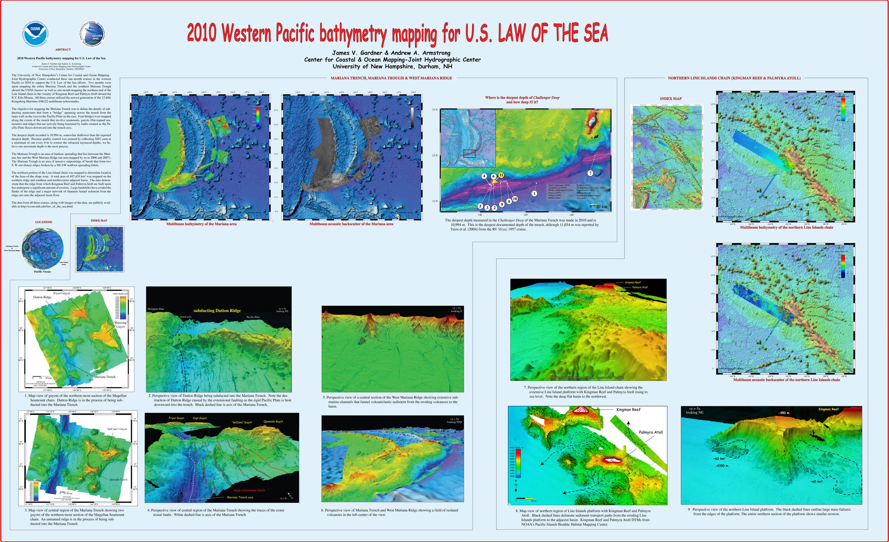
, “2010 Western Pacific bathymetry mapping for U.S. Law of the Sea”, U.S. Hydrographic Conference (US HYDRO). Tampa, FL, USA, 2011. Gardner_2011_USHYDRO_Western_Pacific_bathymetry_for_LOTS.jpg (3.5 MB)
, “Application of the General Bathymetric Chart of the Oceans (GEBCO) Digital Atlas in the Delineation of Continental Shelves Under Article 76”, Journal of Ocean Technology, vol. 3. Journal of Ocean Technology (JOT), pp. 24-29, 2008.
, “Challenges of Collecting Law of the Sea Data in the Arctic: The Arctic and Law of the Sea”, in International Energy Policy, the Arctic and the Law of the Sea, 9th ed., no. M.H. Nordquist, J.N. Moore & A.S. Skaridov, Leiden, South Holland, The Netherlands: Martinus Nijhoff legacy_publishers, 2005, pp. 125-140.
, “Mapping in the Arctic Ocean in Support of a Potential Extended Continental Shelf”, U.S. Hydrographic Conference (US HYDRO). Norfolk, VA, USA, pp. 0-13, 2009. Mayer_09_USHYDRO_Mapping_in_Arctic_in_support_of_potential_ecs.pdf (1.06 MB)
, “U.S. Law of the Sea Cruise to Map the Foot of the Slope and 2500-m Isobath of the Gulf of Alaska Continental Margin. Cruise Report”, University of New Hampshire (UNH), Center for Coastal and Ocean Mapping (CCOM)/Joint Hydrographic Center (JHC), 2005. Gardner_05_cruise_report_KM0514.pdf (9.58 MB)
, “The impacts of a non-accepted boundary claim: Russia’s frontier in the Arctic Ocean”, Association of American Geographers (AAG). Boston, MA, USA, 2008.
, “From Seafloor Mapping to Geological Processes: New Insights in Marine Geomorphic Features Using High-Resolution Acoustic Imaging Techniques”, American Geophysical Union (AGU). San Francisco, CA, USA, 2011.
, “U.S. Law of the Sea Cruise to Map the Foot of the Slope and 2500-m Isobath of the Florida Escarpment and Sigsbee Escarpment, Northern Gulf of Mexico Continental Marg. Cruise Report”, University of New Hampshire (UNH), Center for Coastal and Ocean Mapping (CCOM)/Joint Hydrographic Center (JHC), 2007. Gardner_07_cruise_report_NR07-1.pdf (21.74 MB)
, “Mapping Supports Potential Submission to U.N. Law of the Sea”, EOS Transactions, American Geophysical Union, vol. 87. American Geophysical Union , Washington DC, Washington DC, USA, pp. 157-159, 2006. Gardner_06_Eos_Mapping_supports_potential_submission_to_un_lots.pdf (270.7 KB)
, “New Views of the Gulf of Alaska Margin Mapped for UNCLOS Applications”, University of New Hampshire (UNH), Center for Coastal and Ocean Mapping (CCOM)/Joint Hydrographic Center (JHC), 2005. Mayer_05_Gulf_of_Alaska_Margin_Mapped_for_UNCLOS_applications.pdf (65.49 KB)
, “U.S. Law of the Sea Cruise to Map the Western Flank of the Kingman Reef-Palmyra Atoll Section of the Line Islands, Equatorial Pacific Ocean”, Center for Coastal and Ocean Mapping / Joint Hydrographic Center, Durham, NH, 2015. Cruise-Report-KM1520-Kingman-Palmyra.pdf (10.78 MB)
, “U.S. Extended Continental Shelf Cruise to Map Necker Ridge and Vicinity, Central Pacific Ocean”, 2017. KM17-18-Cruise-Report.pdf (2.07 MB)
, “The Compilation and Analysis of Data Relevant to a U.S. Claim Under United Nations Law of the Sea Article 76: Maps”, U.S. Congress, 2002.
, “From the Arctic to the Tropics: The U.S. UNCLOS Bathymetric Mapping Program”, Canadian Hydrographic Conference (CHC). Victoria, British Columbia, Canada, pp. 1-11, 2008. Gardner_08_CHC_From_the_Arctice_to_the_Tropics.pdf (1.2 MB)
, “U.S. Law of the Sea Cruise to Map and Sample the US Arctic Ocean Margin, Healy 1603”, Center for Coastal and Ocean Mapping / Joint Hydrographic Center, University of New Hampshire, Durham, NH, 2016.
, “U.S. Law of the Sea Cruise to Map the Western Insular Margin and 2500-m Isobath of Guam and the Northern Mariana Islands. Cruise Report”, University of New Hampshire (UNH), Center for Coastal and Ocean Mapping (CCOM)/Joint Hydrographic Center (JHC), 2007. Gardner_07_cruise_report_BD07-1.pdf (2.54 MB)
, “U.S. Extended Continental Shelf Cruise to Map Gaps in Kela and Karin Ridges, Johnston Atoll, Equatorial Pacific Ocean”, CCOM/JHC, Durham, NH, 2014. lots-cruise-report-km14-17-johnston-atoll.pdf (24.43 MB)
, “U.S. Law of the Sea cruises to map sections of the Mariana Trench and the eastern and southern insular margins of Guam and the Northern Mariana Islands”, University of New Hampshire (UNH), Center for Coastal and Ocean Mapping (CCOM)/Joint Hydrographic Center (JHC), 2010. Gardner_2010_cruise_report_SU10-1_Marianas.pdf (4.88 MB)
, “U.S. Law of the Sea Cruise to Map the Eastern Mendocino Ridge, Eastern Pacific Ocean”, University of New Hampshire, Durham, NH, 2009. Gardner_09_cruise_report_EX0903_Mendocino.pdf (2.19 MB)
, “The Compilation and Analysis of Data Relevant to a U.S. Claim Under United Nations Law of the Sea Article 76: A Preliminary Report”, University of New Hampshire (UNH), Center for Coastal and Ocean Mapping (CCOM)/Joint Hydrographic Center (JHC), 2002. Mayer_02_Compilation_analysis_data_relevant_to_UNCLOS_76.pdf (7.88 MB)
, “High Resolution Mapping in support of UNCLOS Article 76: Seeing the seafloor with new eyes”, U.S. Hydrographic Conference (US HYDRO). Norfolk, VA, USA, pp. 12-13, 2007.
, “U.S. Law of the Sea Cruise to Map the Foot of the Slope and 2500-m Isobath of the U.S. Arctic Ocean Margin”, Center for Coastal and Ocean Mapping (CCOM)/Joint Hydrographic Center (JHC), 2011. Mayer_2011_cruise_report_HEALY1102.pdf (12.53 MB)
, “US UNCLOS Multibeam Data: The Processing of Multibeam Bathymetry and Backcatter”, Hydro International, vol. 8. Geomatics Information & Trading Center - GITC, Lemmers, Amsterdam, The Netherlands, pp. 14-17, 2008. Fonseca_al_2008_hydro_intl.pdf (1.42 MB)
, “Report on the LOTS Cruise to Map Foot of the Slope and 2500-m Isobath of Bowers Ridge and Beringian Margin, Bering Sea. Cruise Report”, University of New Hampshire (UNH), Center for Coastal and Ocean Mapping (CCOM)/Joint Hydrographic Center (JHC), 2003. Gardner_03_cruise_report_DA0301.pdf (8.01 MB)
, “U.S. Extended Continental Shelf Cruise to Map Sections of the Mariana Trench and the Eastern and Southern Insular Margins of Guam and the Northern Mariana Islands”, Center for Coastal and Ocean Mapping / Joint Hydrographic Center, 2011. Armstrong_2011_cruise_report_SU10-02_Marianas.pdf (6.86 MB)
, “U.S. Law of the Sea Mapping”, Hydro International, vol. 9. Geomatics Information & Trading Center - GITC, Lemmers, Amsterdam, The Netherlands, pp. 42-45, 2005. Gardner_05_Hydro_US_Law_of_the_Sea_Mapping.pdf (16.23 MB)
, “Western Pacific bathymetry mapping for U.S. Law of the Sea”, U.S. Hydro 2011. Tampa, FL, USA, 2011.
, “NOAA's Role in Defining the U.S.”, Marine Technology Society Journal, vol. 49, No. 2. Marine Technology Society, Washington, D.C., pp. 204-210(7), 2015.
, “Extracting More Data from LiDAR in Forested Areas by Analyzing Waveform Shape”, Remote Sensing, vol. 4. MDPI Publishing, Basel, Switzerland, pp. 682-702, 2012. remotesensing-04-00682-v2-1.pdf (3.89 MB)
, “The Acoustics Environment of the Florida Manatee: Correlation of Noise and Level of Habitat Use”, Journal of the Acoustical Society of America, 2004.
, “A Risk Index Methodology for Potentially Polluting Marine Sites (PPMS)”, Environment Systems and Decisions, vol. 34(3). Springer, pp. 391-405, 2014.
, “Analysis of Coastal Morphology for Crescent and Sea Point Beaches, Maine Ground-truth Airborne LIDAR Bathymetry Digital Elevation Models”, Shallow Water Survey Conference (SWS). Durham, NH, USA, 2008.
, “Hydrographic Survey Bottom Sampling Specifications: A Remote Sensing Perspective”, Canadian Hydrographic Conference (CHC). Quebec City, Quebec, Canada, 2010.
, “Evaluation of Field-Measured Vertical Obscuration and Full Waveform Lidar to Assess Salt Marsh Vegetation Biophysical Parameters”, Remote Sensing of Environment, vol. 156. pp. 264-275, 2015.
, “Mosaicing Tool for Aerial Imagery from a Lidar Bathymetry Survey”, International Hydrographic Review, vol. 9. Geomatics Information & Trading Center - GITC, Lemmers, Amsterdam, The Netherlands, pp. 35-44, 2006.
, “Shoreline mapping resolved from airborne LIDAR bathymetry (ALB) waveforms.”, Journal of Coastal Research, Special Issue: Applied LIDAR Techniques, vol. 62. Coastal Education & Research Foundation, Inc. [CERF], West Palm Beach, FL, USA, pp. 75-85, 2011.
, “Airborne Lidar Bathymetry Products for Shoreline Mapping”, Joint Airborne LIDAR Bathymetry Technical Center of Expertise Coastal Mapping and Charting Workshop (JALBTCX). San Francisco, CA, USA, 2008.
, “Data Fusion - Hyperspectral, Topo Lidar and High-Resolution Imagery”, Joint Airborne LIDAR Bathymetry Technical Center of Expertise Coastal Mapping and Charting Workshop (JALBTCX). St. Petersburg Beach, FL, USA, 2004.
, “Exploiting Full-Waveform Lidar Data and Multiresolution Wavelet Analysis for Vertical Object Detection and Recognition”, IEEE International Geoscience and Remote Sensing Symposium (IGARSS). Barcelona, Barcelona, Spain, 2007. Parrish_2007_Exploiting_Full_WaveForm_LIDAR_Data.pdf.pdf (857.3 KB)
, “New Approach to Autoextraction and Attribution of Airport Obstructions from LIDAR Data”, Transportation Research Board (TRB) . Washington DC, Washington DC, USA, 2008.
, “Lake Tahoe Bottom Characteristics Extracted from SHOALS Lidar Waveform Data and Compared to Backscatter Data From a Multibeam Echo Sounder”, 2002 Fall Meeting, American Geophysical Union. American Geophysical Union , San Francisco, CA, 2002. Elston_2002_AGU_Lake_tahoe_bottom_chars_from_shoals_lidar.jpg (766 KB)
, “Registration of the Hyperspectral Data to Aerial Photography (USACE's CHARTS Systems).”, FUDOTERAM Workshop Reminder on LiDAR Bathymetric Studies. Montreal, Quebec, Canada, 2009.
, “Robust Characterization of SHOALS Lidar Signals for Bottom Segmentation and Classification: A Combined Parameter-estimation and Curve Fitting Approach”, American Society for Photogrammetry and Remote Sensing (ASPRS). Denver, CO, USA, pp. 0-0, 2004.
, “Simulating an Airborne Lidar Bathymetry (ALB) System”, Optical Remote Sensing of the Environment (ORS). Tucson, AZ, USA, 2010.
, “Identifying subtidal coastal environments using airborne lidar bathymetry (ALB)”, American Geophysical Union (AGU). San Francisco, CA, USA, 2007.
, “Lake Tahoe bottom characteristics extracted from SHOALS lidar waveform data and compared to backscatter data from a Multibeam echo sounder”, EOS Transactions, American Geophysical Union , vol. 83. San Francisco, CA, USA, pp. 0-0, 2002.
, “Assimilation of airborne imagery with a wave model for bathymetric estimation.”, Journal of Coastal Research, Special Issue: Applied LIDAR Techniques, vol. 62. Coastal Education & Research Foundation, Inc. [CERF], West Palm Beach, FL, USA, pp. 40-49, 2011. 15_monfort_lippmann_2011.pdf (452.91 KB)
, “Analysis of Lidar Leaf Penetration Indices for Selected Plant Species in a Coastal Marsh and Correlation with Terrain Elevation Accuracy”, American Society for Photogrammetry and Remote Sensing (ASPRS). Baltimore, MD, USA, 2009.
, “Applications”, in Airborne Topographic Lidar Manual, Bethesda, Maryland: American Society for Photogrammetry and Remote Sensing (ASPRS), 2012, pp. 283-423.


