Publications
, “Multibeam Mapping of the Los Angeles, California Margin”, U.S. Geological Survey (USGS), 2002.
, “Reevaluating Stereo and Motion Cues for Visualizing Graphs in Three Dimensions”, ACM SIGGRAPH Symposium on Applied Perception in Graphics and Visualization (APGV). Coruna, Coruna, Spain, pp. 51-58, 2005.
, “Remote estimation of surficial seafloor properties through the application Angular Range Analysis to multibeam sonar data”, Marine Geophysical Researches, vol. 28. Springer Publisher, New York, NY, USA, pp. 119-126, 2007.
“Visualizing the Operations of the Phoenix Mars Lander”, American Geophysical Union (AGU). San Francisco, CA, USA, 2008.
, “Using the Bat: A Six Dimensional Mouse for Object Placement”, IEEE Computer Graphics and Application. IEEE, Washington DC, Washington DC, USA, pp. 65-70, 1988.
, “Shoreline Mapping Using LIDAR Red-channel Waveforms”, American Geophysical Union (AGU). San Francisco, CA, USA, 2006.
, “Measurements of ambient bubble populations with a multibeam sonar”, Acoustical Society of America (ASA). St. Andrews, New Brunswick, Canada, pp. 0-0, 2002.
, “Differential Phase Estimation with the SeaMARC II Bathymetric Sidescan Sonar System”, IEEE Journal of Oceanic Engineering, vol. 17. IEEE, Washington DC, Washington DC, USA, pp. 239-251, 1992.
, Information Visualization: Perception for Design, 2nd ed. Burlington, MA, USA: Morgan Kaufman, 2004, p. 435.
, “High-resolution Multibeam Mapping of Crater Lake, Oregon”, EOS Transactions, American Geophysical Union , vol. 81. San Francisco, CA, USA, pp. 0-0, 2000.
, “Analysis of Coastal Morphology for Crescent and Sea Point Beaches, Maine Ground-truth Airborne LIDAR Bathymetry Digital Elevation Models”, Shallow Water Survey Conference (SWS). Durham, NH, USA, 2008.
, “New Paradigms for Hydrographic Data Processing and Products”, International Conference on High-Resolution Survey in Shallow Water (HRSSW). St. Andrews, New Brunswick, Canada, pp. 0-0, 2003.
, “A New Look at Northwind Ridge: Implications for the History of the Canada Basin”, American Geophysical Union (AGU). San Francisco, CA, USA, 2010.
, “Seafloor Characterization Through the Application of AVO Analysis to Multibeam Sonar Data”, University of Bath Boundary Influences in High Frequency Shallow Water Acoustics. Bath, UK, UK, pp. 0-0, 2005.
, “Fred Fisher's high pressure work with eyewash and epsom salts”, Journal of the Acoustical Society of America, vol. 120. Acoustical Society of America, Melville, NY, USA, pp. 3299-3299, 2006.
, “Hyperspectral airborne remote sensing for assessing water quality and clarity in the Great Bay Estuary of New Hampshire”, Ocean Sciences Meeting. Orlando, FL, USA, 2008.
, “Precise Distributed Timekeeping in Hydrographic Survey”, Systems Professional Surveyor Magazine, vol. 29. Flatdog Media Inc., Frederick, MD, USA, 2009.
, “Quality Assurance of Airborne Lidar Bathymetry Products for Shoreline Mapping”, American Geophysical Union (AGU). San Francisco, CA, USA, 2007.
, “Subjective Contours Independent of Subjective Brightness”, Perception and Psychophysics, vol. 29. Psychonomic Society, pp. 500-504, 1981.
, “Making Useful and Useable Geovisualization: Design and Evaluation Issues”, in Exploring Geovisualization, no. J. Dykes, A.M. MacEachren & M.J. Kraak, New York, NY, USA: Elsevier, 2005, pp. 541-554.
, “GEBCO Cookbook, Errors and Uncertainty in the Gridded Bathymetry”, GEBCO. Durham, NH, USA, 2010.
, “Passive Force Feedback for Velocity Control”, ACM Computer Human Interaction (CHI). Boston, MA, USA, pp. 255-256, 1994.
, “High-resolution Photo-mosaicing of the Rosebud Hydrothermal Vent Site and Surrounding Lava Flows, Galapagos Rift 86W: Techniques and Interpretation”, EOS Transactions, American Geophysical Union , vol. 84. San Francisco, CA, USA, pp. 0-0, 2003.
, “Morphology and processes in Lake Tahoe (California-Nevada)”, Geological Society of America Bulletin (GSAB), vol. 112. The Geological Society of America (GSA), pp. 736-746, 2000.
, “Mapping Benthic Habitat at Various scales in the Olympic National Marine Sanctuary, WA”, National Shellfisheries Association (NSA). New Orleans, LA, USA, pp. 0-0, 2002.
, “Simultaneous Water Column and Seafloor Mapping with the Simard ME70”, FEMME - Kongsberg (users conference). Lisbon, Lisbon, Portugal, 2009.
, “Drowned barrier-island complexes and shelf-edge deltas on the northwest Florida outer continental self”, Geomorphology, vol. 64. Elsevier, New York, NY, USA, pp. 133-166, 2004.
, “Crater Lake Revealed - Investigations I-2790”, U.S. Geological Survey (USGS), 2003.
, “Optical Image Blending for Underwater Mosaics”, IEEE Oceans. Boston, MA, USA, 2006.
, “Simulating an Airborne Lidar Bathymetry (ALB) System”, Optical Remote Sensing of the Environment (ORS). Tucson, AZ, USA, 2010.
, “A 60 k.y. record of extension across the western boundary of the Basin and Range Province: Estimate of slip-rates from offset shoreline terraces and a catastrophic slide beneath Lake Tahoe”, Geology, vol. 33. The Geological Society of America (GSA), pp. 365-368, 2005.
, “Digital Security in the Open Navigation Surface Model”, University of New Hampshire (UNH), Center for Coastal and Ocean Mapping (CCOM)/Joint Hydrographic Center (JHC), 2004.
, “Visual Thinking with Interactive Diagram”, Lecture Notes on Artificial Intelligence, vol. 5223. Springer Publisher, New York, NY, USA, pp. 118-126, 2008.
, “Marine Ship Automatic Identification System (AIS) for Enhanced Coastal Security Capabilities: An Oil Spill Tracking Application”, IEEE Oceans. Vancouver, British Columbia, Canada, pp. 1-9, 2007.
, “Sidescan Sonar Image Enchancement Using a Decomposition Based on Orthogonal Functions. Applications with Chebyshev Polynomials”, IEEE Oceans. St. Andrews, New Brunswick, Canada, pp. 942-947, 1991.
, “Lake Tahoe bottom characteristics extracted from SHOALS lidar waveform data and compared to backscatter data from a Multibeam echo sounder”, EOS Transactions, American Geophysical Union , vol. 83. San Francisco, CA, USA, pp. 0-0, 2002.
, “Multimedia Output Devices and Techniques”, ACM Computing Surveys, vol. 28. Association for Computing Machinery (ACM), New York, NY, USA, pp. 181-183, 1996.
, “Seafloor Habitat Mapping: Considering Techniques for Expansion of Spatial Scales”, Workshop on Deep-Seabed Survey Technologies. Bergen, Bergen, Norway, pp. 0-0, 2001.
, “Diagramming Information Structures Using 3D Perceptual Primitives”, ACM Transactions on Computer-Human Interaction (CHI), vol. 10. Association for Computing Machinery (ACM), New York, NY, USA, pp. 1-19, 2003.
, “A study of Haptic Linear and Pie Menus in a 3D Fish Tank VR Environment”, International Symposium on Haptics Interfaces for Virtual Environments and Teleoperator Systems (HAPTICS). Chicago, IL, USA, pp. 224-231, 2004.
, “Multibeam Mapping of the Pinnacles Region, Gulf of Mexico”, U.S. Geological Survey (USGS), 2002.
, “Concurrent optical and acoustic scattering measurements in bubble clouds”, Underwater Acoustic Measurements: Technologies & Results (UAM). Heraklion, Crete, Greece, pp. 0-0, 2005.
, “Acoustic Propagation in Bubble Clouds Exhibiting Spatial Structure in the Fluctuating Number Density”, IEEE Journal of Oceanic Engineering, vol. 32. IEEE, Washington DC, Washington DC, USA, pp. 513-523, 2007.
, “Using Color Dimensions to Display Data Dimensions”, ACM Computing Surveys, vol. 30. Association for Computing Machinery (ACM), New York, NY, USA, pp. 127-142, 1988.
, “Layout for Visualizing Large Software Structures in 3D”, Interanational Conference on Visual Information Systems (VISUAL). San Diego, CA, USA, pp. 215-223, 1997.
, “Identifying subtidal coastal environments using airborne lidar bathymetry (ALB)”, American Geophysical Union (AGU). San Francisco, CA, USA, 2007.
, “3-D visualization for pelagic fisheries assessment and research”, ICES Journal of Marine Science, vol. 59. Elsevier, New York, NY, USA, pp. 216-225, 2001.
, “USCG Development, Test and Evaluation of AIS Binary Messages for Enhanced VTS Operations”, Institute of Navigation. Anaheim, CA, USA, 2009.
, “Canadian e-Navigation User Needs Survey: Report on Comprehensive Results”, Canadian Coast Guard, 2010.
, “Contour Perception and Components of the Visual Array”, Society of Photographic Scientists and Engineers. Rochester, NY, USA, 1977.
, “Simple Animation as a Human Interrupt”, International Journal of Human-Computer Studies, vol. 4. Elsevier, New York, NY, USA, pp. 341-348, 1992.
, Visual Thinking for Design. Boca Raton, FL, USA: CRC Press, LLC, 2008.
, “Robust Automatic Multi-beam Bathymetric Processing”, U.S. Hydrographic Conference (US HYDRO). Norfolk, VA, USA, pp. 0-20, 2001.
, “The Development of Chirp Sonar Technology and Its Applications”, EOS Transactions, American Geophysical Union , vol. 81. San Francisco, CA, USA, pp. 0-0, 2000.
, “Clustered Scatters: The Effect on the Mean Acoustic Field”, Meeting of the Acoustical Society of America (ASA). Paris, Paris, France, 2008.
, “The Navigation Surface: A New Database Approach to Creating Multiple Products from High-Density Surveys”, International Hydrographic Review, vol. 3. Geomatics Information & Trading Center - GITC, Lemmers, Amsterdam, The Netherlands, pp. 12-16, 2002.
, “The Integrated Seafloor: Efficient Multi Sensor Processing and Visualization Techniques for Seafloor Mapping Data”, International Hydrographic Conference (HYDRO). Christchurch, Christchurch, New Zealand, pp. 0-0, 2003.
, “Observations Near the Well Head using Vessel Mounted Scientific Echo Sounders”, Acoustical Society of America (ASA). Cancun, Quintana Roo, Mexico, 2010.
, “Adapting CUBE for Phase Measuring Bathymetric Sonars”, International Conference on High-Resolution Survey in Shallow Water (HRSSW). Plymouth, Devon, UK, pp. 0-0, 2005.
, “A Process for Producing Ice Coverage Marine Information Objects (MIOs) in IHO S-57 Format”, International Hydrographic Review, vol. 7. Geomatics Information & Trading Center - GITC, Lemmers, Amsterdam, The Netherlands, pp. 55-63, 2006.
, “WASSP sea tests M/V Acheron”, US Army Corps of Engineers(USACE), 2006.
, “Improved Approach to LIDAR Airport Obstruction Surveying Using Full-Waveform Data”, Journal of Surveying Engineering, vol. 135. Amercian Society of Civil Engineers , Reston, VA, USA, pp. 72-82, 2009.
, “Human Axial Chromatic Aberration Found Not to Decline with Age, Graefes Archiv”, Ophthalmologie: Journal of The American Academy of Ophthalmology, vol. 218. Elsevier, New York, NY, USA, pp. 39-41, 1982.
, “Visual Queries: The Foundation of Visual Thinking”, in Knowledge and Information Visualization: Searching for Synergies, no. S. Tergan & T. Keller, New York, NY, USA: Springer Publisher, 2005, pp. 25-33.
, “Aplicação de geoprocessamento, processamento digital de imagens e fotogrametria terrestre no rastreamento litofaciológico de afloramentos (Use of geoprocessing, digital image processing and terrestrial photogrametry for tracing lithof”, Brazilian Symposium of Quantification on Geosciences (BSQG). Rio Claro, Sao Paulo, Brazil, pp. 0-0, 1995.
, “High-resolution Holocene Records of Paleoceanographic and Paleoclimatic Variability from the Southern Alaskan Continental Margin”, EOS Transactions, American Geophysical Union . San Francisco, CA, USA, pp. 0-0, 2004.
, “A Reappraisal of Deepwater Reefs Along the NW Florida Outer Continental Shelf”, UC Santa Cruz Marine Sciences Seminar . St. Andrews, New Brunswick, Canada, pp. 0-0, 2002.
, “The Marine Geology off Southern California”, Geological Society of America (GSA). St. Andrews, New Brunswick, Canada, pp. 0-0, 2004.
, “e-Navigation: Challenges and Opportunities.”, Inland Navigation Technology. Vicksburg, MS, USA, 2009.
, “Multibeam Error Management: New Data Processing Trends in Hydrography”, Hydro International, vol. 8. Geomatics Information & Trading Center - GITC, Lemmers, Amsterdam, The Netherlands, pp. 6-9, 2004.
, “Application of the General Bathymetric Chart of the Oceans (GEBCO) Digital Atlas in the Delineation of Continental Shelves Under Article 76”, Journal of Ocean Technology, vol. 3. Journal of Ocean Technology (JOT), pp. 24-29, 2008.
, “Detection of Bottom Fishing Impacts on Benthic Structure Using Multibeam Sonar, Side Scan Sonar, Video and Interactive 3-D GIS”, GIS Conference. Cambridge, MA, USA, 2006.
, “Harmonization of European and North American Inland ECDIS Standards”, International ECDIS Conference. Singapore, Singapore, Singapore, pp. 0-0, 2003.
, “Data Fusion - Hyperspectral, Topo Lidar and High-Resolution Imagery”, Joint Airborne LIDAR Bathymetry Technical Center of Expertise Coastal Mapping and Charting Workshop (JALBTCX). St. Petersburg Beach, FL, USA, 2004.
, “Gorda Ridge Revisited: the R/V Okeanos Explorer Conducts its First Hydrothermal Plume Survey”, Ocean Sciences Meeting. Portland, OR, USA, 2010.
, “High-Resolution Mapping of Mines and Ripples at the Martha's Vineyard Coastal Observatory”, IEEE Journal of Oceanic Engineering, vol. 32. IEEE, Washington DC, Washington DC, USA, pp. 133-149, 2005.
, “Calibration of a Reson SeaBat 8101 Multibeam Echosounder”, Penn State University, 2004.
, “Acoustic positioning and tracking in Portsmouth Harbour, New Hampshire”, IEEE Oceans. Vancouver, British Columbia, Canada, pp. 0-0, 2007.
, “Signal Processing for Swath Bathymetry and Concurrent Seafloor Acoustic Imaging”, in Acoustic Signal Processing for Ocean Exploration, no. J.M. Moura & I.M. Lourtie, Amsterdam, North Holland, The Netherlands: Kluwer Academic, 1993, pp. 329-354.
, “Establishing an IALA AIS Binary Message Register: Recommended Process”, International Association of Aids to Navigation and Lighthouse Authorities (IALA-AISM). Cape Town, Western Cape, South Africa, pp. 108-115, 2010.
, “Ocean Mapping Initiatives in Canada”, Canadian Hydrographic Conference (CHC). Rimouski, Quebec, Canada, pp. 1-7, 1991.
, “Assessing Damage on the Major Submarine Deltas of Southern Puget Sound After the 2001 Nisqually Earthquake Using High-Resolution Seafloor Multibeam Mapping”, Geological Society of America (GSA), vol. 34. Corvallis, OR, USA, pp. 0-0, 2002.
, “Three Dimensional Imaging of the Belousov Zhabotinsky Reaction using Magnetic Resonance”, Magnetic Resonance Imaging, vol. 15. Elsevier, New York, NY, USA, pp. 719-728, 1997.
, “Interactive 3D visualization and analysis of multi-sensor, multi-relolution data sets”, International Conference on High-Resolution Survey in Shallow Water (HRSSW). Portsmouth, NH, USA, 2001.
, “Quantification of Glacimarine Sediment Yields Using Multibeam Sonar in Alaskan Fjords”, American Geophysical Union (AGU), vol. 89. San Francisco, CA, USA, 2008.
, “Physiographic Provinces of the Arctic Ocean Seafloor”, Geological Society of America Bulletin (GSAB), vol. 115. The Geological Society of America (GSA), pp. 1443-1455, 2003.
, “Integrated Navigation System: Not a Sum of Its Parts”, Canadian Hydrographic Conference (CHC). St. Andrews, New Brunswick, Canada, pp. 0-0, 2004.
, “A Prototype 1:6 Million Map ”, University of Hawaii, 2002.
, “Observations of a geoclutter feature in the straits of Sicily”, Acoustical Society of America (ASA). St. Andrews, New Brunswick, Canada, pp. 0-0, 2005.
, “GEBCO and Deep Water: data assembler, converter, interpreter and disseminator”, Hydro International, vol. 11. Geomatics Information & Trading Center - GITC, Lemmers, Amsterdam, The Netherlands, pp. 7-9, 2007.
, “Environmental Response Management Application”, International Oil Spill Conference (IOSP). Savannah, GA, USA, 2008.
, “Precise Naviation and Maneuverin in Ports, Evaluation Report for EFFORTS Project Work Package 1.2”, ISSUS/Hamberg Port Authority, EC Contract No FP6-031486, 2009.
, “A Simple Heuristically-Based Method for Expressive Stimulus-Response Animations”, Computer Graphics, vol. 13. Association for Computing Machinery (ACM), New York, NY, USA, pp. 297-303, 1989.
, “High Resolution Side-Scan and Seismic Images of Landslides on the Northern California Continental Shelf”, American Geophysical Union (AGU). San Francisco, CA, USA, pp. 0-0, 1998.
, “First Recovery of Submarine Basalts from the Chukchi Borderland and Alpha/Mendeleev Ridge, Arctic Ocean”, American Geophysical Union (AGU), vol. 89. San Francisco, CA, USA, pp. 2123-2124, 2007.
, “Advanced Mid-Water Tools for 4D Marine Data Fusion and Visualization”, IEEE Oceans. Biloxi, MS, USA, 2009.
, “Choosing a Colour Sequence for Univariate Maps”, IEEE Conference on Systems, Man & Cybernetics. New York, NY, USA, pp. 41-45, 1986.
, The Electronic Chart: Functions, Potential and Limitations of a New Navigation System, 3rd ed., no. Adam Kerr. Lemmers, Amsterdam, The Netherlands: GeoMares Publishing, 2010, pp. 1-441.
, “Field Evaluation of Sounding Accuracy in Deep Water Multibeam Swath Bathymetry”, IEEE Oceans, vol. 3. Honolulu, HI, USA, pp. 1761-1765, 2001.
, “Assessing the 'GEO' in GEOCLUTTER: New Chirp Sonar, Sampling, and Compressional Wave Veolcity Results from the New Jersey Shelf”, EOS Transactions, American Geophysical Union , vol. 82. San Francisco, CA, USA, pp. 0-0, 2001.
, “Detecting bedform migration in Portsmouth Harbor on relatively short time-scales from high-resolution multibeam bathymetry”, Shallow Water Survey Conference (SWS). Durham, NH, USA, 2008.
, “Working from Top to Bottom with the ME70 Multibeam Echosounder”, ICES Working Group on Fisheries Acoustics, Science and Technology. San Diego, CA, USA, pp. 4-4, 2010.
, “Insitu Measurement of Sediment Acoustic Properties”, International Conference for Underwater Acoustic Measurements (ICUAM). Heraklion, Crete, Greece, pp. 0-0, 2005.
, “Recommendation for Involving the Private Sector in Producing Small-scale ENCs from INT Charts”, University of New Hampshire (UNH), Center for Coastal and Ocean Mapping (CCOM)/Joint Hydrographic Center (JHC), 2006.
, “Status Report on International Inland ENC Developmnet and Standardization”, The Radio Technical Commission for Maritime Services (RTCM). St. Petersburg Beach, FL, USA, 2007.
, “The Chromatic Cornsweet Effect”, Vision Research, vol. 11. Elsevier, New York, NY, USA, pp. 1075-1077, 1983.
, “Another dimension from LiDAR – Obtaining foliage density from full waveform data
”, SilviLaser. Hobart, Tasmania, Australia, 2011.
, “Dynamic Stereo Displays”, ACM Computer Human Interaction (CHI). Denver, CO, USA, pp. 311-316, 1995.
, “Mosaicking Techniques for Deep Submergence Vehicle Video Imagery - Applications to Ridge2000 Science”, EOS Transactions, American Geophysical Union . San Francisco, CA, USA, pp. 0-0, 2004.
, “Filtering and Intergrating Visual Information with Motion”, Information Visualization, vol. 1. Palgrave Macmillan, pp. 66-79, 2001.
, “Variable Bandwidth Filter for Multibeam Echosounding Bottom Detection”, IEEE Oceans. Kobe, Kobe, Japan, pp. 1154-1158, 2004.
, “Oceanic Transform Fault Seismicity Earthquakes of a Different Kind”, International Workshop on Statistical Seismology. Lake Tahoe, CA, USA, 2009.
, “GEBCO: The Second Century. Looking Towards a General Bathymetric Chart”, Hydro International, vol. 8. Geomatics Information & Trading Center - GITC, Lemmers, Amsterdam, The Netherlands, pp. 45-47, 2004.
, “Activities of IHO-IEC Harmonization Group on Marine Information Objects (HGMIO)”, International Hydrographic Office (IHO), CHRIS, 2004.
, “High-precision, High-accuracy Timekeeping in Distributed Survey Systems”, International Hydrographic Review, vol. 9. Geomatics Information & Trading Center - GITC, Lemmers, Amsterdam, The Netherlands, pp. 9-24, 2008.
, “Deep Sea Geo-referenced Video Mosaics”, IEEE Oceans. Boston, MA, USA, 2006.
, “1-6.3-CoastPilotDataStructure”, International Hydrographic Organization, Monaco, 2015. NIPW 1-6.3-CoastPilotDataStructure.pdf (6.83 MB)
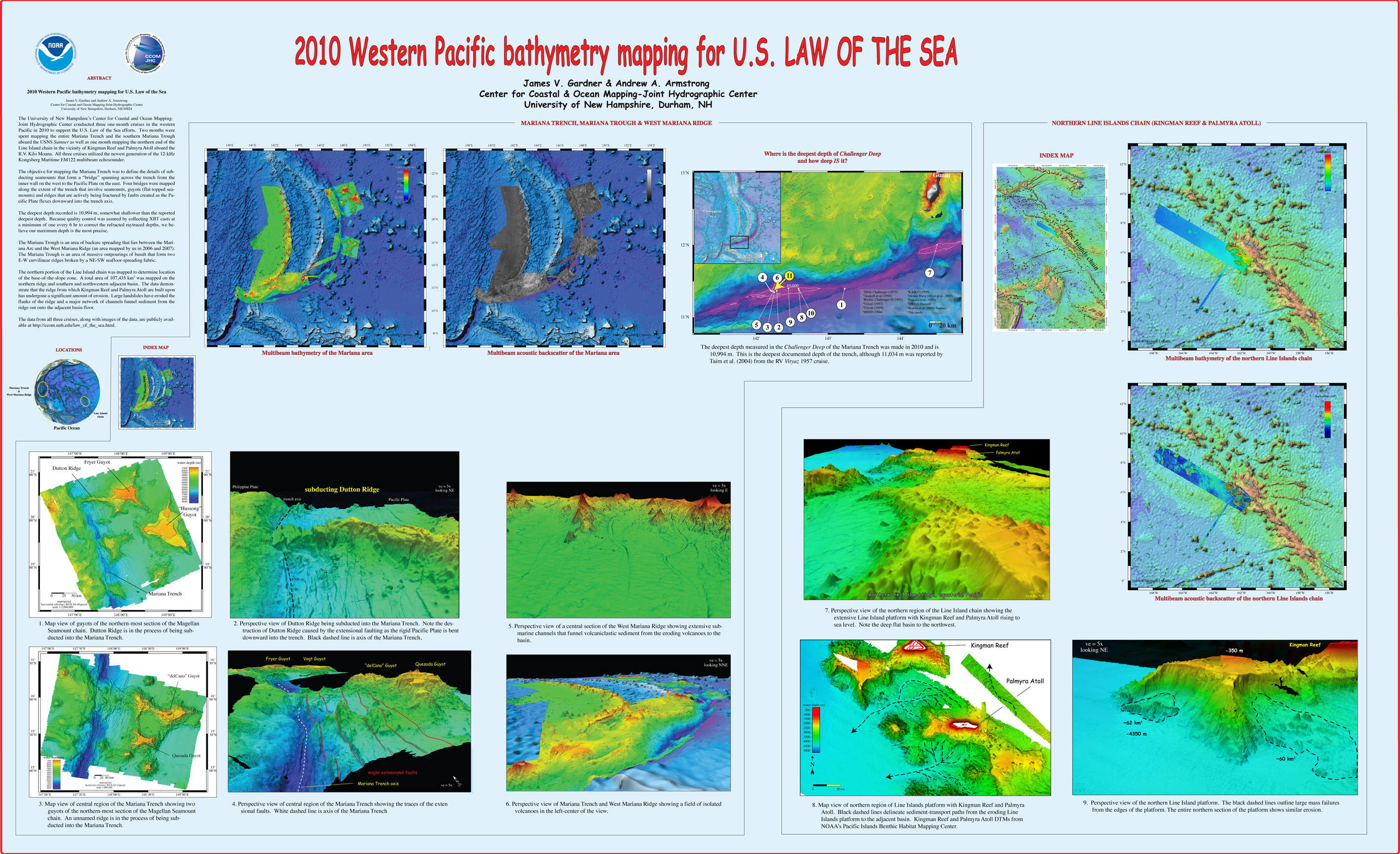
, “2010 Western Pacific bathymetry mapping for U.S. Law of the Sea”, U.S. Hydrographic Conference (US HYDRO). Tampa, FL, USA, 2011. Gardner_2011_USHYDRO_Western_Pacific_bathymetry_for_LOTS.jpg (3.5 MB)
, “3D Contour Perception for Flow Visualization”, ACM SIGGRAPH Symposium on Applied Perception in Graphics and Visualization (APGV). Boston, MA, USA, pp. 101-106, 2006. Ware-2006-SIGGRAPH-3D-Contour-Perception-for-Flow-Visualization.pdf (264.46 KB)
, “Acoustic and Geomorphological Signatures of Gas Seeps on the East Siberian Margin”, 2016 Graduate Research Conference. University of New Hampshire, Durham, NH, 2016.
, “Acoustic and optical observations of methane gas seeps in the Gulf of Mexico”, Proceedings of Meetings on Acoustics, vol. 19. 2013.
, “Acoustic backscattering observations from non-spherical gas bubbles with ka between 0.03 – 4”, Journal of the Acoustical Society of America, vol. 149(4). pp. 2504-2519, 2021.
, “Acoustic Calibration and Bathymetric Processing with an L-3 Klein 5410 Sidescan Sonar”, 2007. Glynn_2007_MS-Thesis_Acoustic_Calibration_and_Bathymetric_Processing_with_L-3_Klein_5410.pdf (3.54 MB)
, “Acoustic Detection and Quantification of Crude Oil”, University of New Hampshire, Durham, NH, 2019.
, “Acoustic Documentation of Temperate Odontocetes in the Bering and Chukchi Seas”, Marine Mammal Science, vol. 35. Society for Marine Mammalogy, pp. 1099-1111, 2019. Seger_et_al-2019-Marine_Mammal_Science.pdf (3.33 MB)
, “Acoustic estimates of methane gas flux from the seabed in a 6000 km2 region of the Northern Gulf of Mexico”, Geochemistry, Geophysics, Geosystems, vol. 15, no. 5. AGU, pp. 1911-1925, 2014. ggge20450.pdf (1.66 MB)
, “Acoustic Mapping of Mixed Layer Depth”, Ocean Science, vol. 14, 3. pp. 503-514, 2018.
, “Acoustic Mapping of Thermohaline Staircases in the Arctic Ocean”, Nature Scientific Reports, vol. 7:15192. Springer Nature, pp. 1-9, 2017. Stranne_et_al_2017_Acoustic_Mapping_of_Thermohaline_Staircases.pdf (3.65 MB)
, “Acoustic Measurements of a Controlled Gas Seep”, The Journal of the Acoustical Society of America, vol. 141(5). Acoustical Society of America, pp. 3524-3524, 2017.
, “Acoustic Methods for Mapping and Characterizing Submerged Aquatic Vegetation Using a Multibeam Echosounder”, University of New Hampshire, Durham, NH, 2019.
, “Acoustic Monitoring and Tracking of Natural Hydrocarbons Gas Bubbles Over the Course of a Year”, Science and Ocean Engineering Graduate Research Symposium. p. Virtual, 2021.
, “Acoustic observations and characterization of oceanic methane gas bubbles rising from the seabed”, The Journal of the Acoustical Society of America, vol. 140(4). Acoustical Society of America, pp. 3077-3077, 2016.
, “Acoustic observations of oil and gas in the northern Gulf of Mexico during and after the Deepwater Horizon spill”, 243rd Meeting of the American Chemical Society. 2012.
, “Acoustic observations of the deep scattering layer during the Deepwater Horizon oil spill”, 161st meeting of the Acoustical Society of America. Seattle, WA, USA, 2011.
, “Acoustic Predictors of Active Fluid Expulsion From a Hydrothermal Vent Field, Offshore Taupō Volcanic Zone, New Zealand”, Frontiers in Earth Science, vol. 9:785396. 2022.
, “The Acoustic Properties of Three Crude Oils at Oceanographically Relevant Temperatures and Pressures”, The Journal of the Acoustical Society of America, vol. 142(4). Acoustical Society of America, pp. 2506-2506, 2017.
, “Acoustic Ranging in a Dynamic, Multipath Environment”, 2008. Weirathmueller_2008_MS-Thesis_Acoustic_Ranging_in_Dynamic_Multipath_Environment.pdf (10.07 MB)
, “On Acoustic Reflection from Sand-Sized Water-Saturated Granular Media at MHz Frequencies: Measurements, Models and the Role of Speckle”, Journal of the Acoustical Society of America, vol. 148. pp. 3291-3304, 2020.
, “An Acoustic Scattering Model for Stratification Interfaces”, Journal of the Acoustical Society of America, vol. 150(6). Acoustic Society of America, pp. 4353-4361, 2021.
, “Acoustic Scattering of Large Wobbly Bubbles”, Bubbles 2017. Tromso, Norway, 2017.
, “Acoustic sensing of gas seeps in the deep ocean with split-beam echosounders”, 11th European Conference on Underwater Acoustics, Edinburgh, Scotland. 2012.
, “Acoustic Surface Backscatter vs Incidence Angle from Glacial Ice”, FEMME-2013. Boston, MA, USA, 2013.
, “Acoustically Relevant Properties of Four Crude Oils at Oceanographic Temperatures and Pressures”, The Journal of the Acoustical Society of America, vol. 144(5). Acoustical Society of America, 2018.
, “The Acoustics Environment of the Florida Manatee: Correlation of Noise and Level of Habitat Use”, Journal of the Acoustical Society of America, 2004.
, “Acquisizione marina dell’alto strutturale del Mt. Vercelli (Mar Tirreno Centrale) e del golfo di Napoli: descrizione dei rilievi e primi risultati”, GNGTS National Conference, vol. 3. Prato, Italy, Italy, pp. 517-518, 2010. Masetti_2010_3.2_cocchi.pdf (222.04 KB)
, “Active mud volcanoes on the continental slope of the Canadian Beaufort Sea”, Geochemistry, Geophysics, Geosystems, 2015.
, “Adding the “Where” to the “Who and What” — Considering the Seascape Can Help the Study of Biodiversity and Ecosystem Functioning”, 4th World Conference on Marine Biodiversity. p. Montreal (QC), Canada, 2018.
, “Adding Value to Broad-Scale Ocean Exploration Mapping Data Through Standardized Geomorphic Classification and Backscatter Data Analysis”, 2019 Fall Meeting, American Geophysical Union (AGU). p. San Francisco, CA, 2019.
, “ADEON Soundscape and Modeling Metadata Standard. Version 2.0 DRAFT”, TNO for ADEON Prime Contract No. M16PC00003, 2017.
, “Advancement in the Estimation of Gas Seep Flux from Echosounder Measurements”, 2017 US Hydrographic Conference. p. Galveston, TX, 2017.
, “Advances in Defining Fine- and Micro-Scale Pattern in Marine Plankton”, Aquatic Living Resources, vol. 16. Cambridge, pp. 131-136, 2003.
, “Advances in Nearshore Processes Research: Four Decades of Progress”, Shore and Beach, vol. 83(1). ASBPA, pp. 39-52, 2015. 19_holman_etal_2015.pdf (1.12 MB)
, “Advances in the study of marine mammal predator-prey interactions: a novel real-time visualization of independently collected echosounder data using GeoZui4D”, Society for Marine Mammalogy. Quebec City, Quebec, Canada, 2009. Arsenault_2009_SMM_Advances_in_the_study_of_marine_mammal_predator-prey_interactions_a_novel_real-time_visualization_of_independently_collected_echosounder_data_using_GeoZui4D.jpg (3.59 MB)
, “Advancing a Design for Trusted Community Bathymetry”, University of New Hampshire, Durham, NH, 2023. Tauriello-Thesis-2023.pdf (8.36 MB)
, “Africa Partnership Station”, Office of Naval Reasearch (ONR) , Durham, NH, USA, 2011.
, “Aggregation Methods Using Bathymetry Sources of Differing Subjective Reliabilities for Navigation Mapping”, Marine Geodesy, vol. 46. Taylor and Francis, pp. 99-128, 2023.
, “Airborne hyperspectral co-registration independent from attitude and positioning sensors”, Coastal GeoTools 2011. Myrtle Beach, SC, USA, 2011.
, “Airborne Lidar Bathymetry (ALB) Waveform Analysis for Bottom Return Characteristics”, SPIE Defense and Commercial Sensing. Baltimore, MD, 2016.
, “Airborne Lidar Bathymetry Beam Diagnostics Using an Underwater Optical Detector Array”, University of New Hampshire, Durham, NH, 2017. Matthew_Birkebak_FinalThesis.pdf (6.43 MB)
, “AIS Application-Specific Messages: Expectation and Reality”, Sea Technology, vol. 53, No. 3. p. 69, 2012.
, “AIS Binary Message Format Using XML to Provide Hydrographic-related Information”, U.S. Hydrographic Conference (US HYDRO). The Hydrographic Society of America, Norfolk, VA, 2007. Schwehr_07_USHYDRO_AIS_binary_format_using_xml_for_hydrographic_info.jpg (481.49 KB)
, “ALB Evaluation for NOAA charting requirements”, Hydro International, vol. 17(8). pp. 24-27, 2013. Imahori_et_al_2013_Hydro_Int.pdf (786.37 KB)
, “Algorithmic Implementation of the Triangle Test for the Validation of Charted Soundings”, 7th International Conference on Cartography & GIS. Bulgarian Cartographic Association, Sozopol, Bulgaria, pp. 569-576, 2018. Kastrisios_Calder_2018_Triangle_test_implementation_Proceedings_ICCGIS2018.pdf (1.49 MB)
, “Alpha / Mendeleev Ridge and Chukchi Borderland 40Ar/39Ar Geochronology and Geochemistry: Character of the First Submarine Intraplate Lavas Recovered from the Arctic Ocean”, EGU General Assembly 2015, vol. 17. Vienna, Austria, 2015.
, “Alternating Asymmetric Swimming Strokes in California Sea Lions”, 21st Biennial Conference on the Biology of Marine Mammals. Society for Marine Mammalogy, San Francisco, CA, 2015.
, “An alternative methodology (to the star symbols).”, International Hydrogarphic Organization, Monaco, 2020.
, “Alumni of the First Ten Years of Nippon Foundation/GEBCO Postgraduate Certificate in Ocean Bathymetry Training Program”, Fifth Extraordinary International Hydrographic Conference . Monaco, 2014.
, “Ambiguity of Underwater Color Measurement and Color-based Habitat Classification”, 4th Topical Meeting on Blue Photonics. Barcelona, Spain, 2015. BluePhotonics15-CCOM.pdf (133.62 KB)
, “Amplified Climate Sensitivity of Northern Greenland Fjords through Sea-Ice Damming”, Communications Earth & Environment, vol. 2(70). 2021.
, “Analysis of Acoustic Scattering Layers In and Around Petermann Fjord, Northwest Greenland”, University of New Hampshire, Durham, NH, 2022.
, “Analysis of Airborne Lidar Bathymetry (ALB) Bottom Return Waveforms”, 17th Annual JALBTCX Airborne Coastal Mapping and Charting Workshop. Silver Spring, MD, 2016.
, “Analysis of CLCS Recommendations in Light of Their Relevance to the Delineation of a United States Extended Continental Shelf (ECS) in the Arctic”, University of New Hampshire, Durham, NH, 2016. irish-onni-thesis.pdf (20.48 MB)
, “Analysis of the Radiated Sound Field of Deep Water Multibeam Echo Sounders for Return Intensity Calibration Using an Underwater Hydrophone Array”, The Journal of the Acoustical Society of America, vol. 142(2). Acoustical Society of America, pp. 2731-2731, 2017.
, “Analysis of the Radiated Soundfield of a Deep Water Multibeam Echosounder Using a Submerged Navy Hydrophone Array”, University of New Hampshire, Durham, NH, 2019.
, “Analysis of Uncertainty in Underwater Multiview Reconstruction”, University of New Hampshire, Durham, NH, 2018. kozlov-ms-2018.pdf (793.6 KB)
, “Analysis of Vibracores from the New Hampshire Continental Shelf from 1984 and 1988”, Department of Interior, Bureau of Ocean Energy Management, Marine Minerals Division, Sterling, VA, 2021.
, “Analytic solution for the forced mean cross-shore flow in the surf zone”, International Conference on Coastal Engineering (ICCE). ASCE, Hamburg, Hamburg, Germany, pp. 789-797, 2009. 20_lippmann_2009.pdf (1.02 MB)
, “Angular dependence of 12-kHz seafloor acoustic backscatter”, Journal of the Acoustical Society of America, vol. 90. Acoustical Society of America, Melville, NY, USA, pp. 522-531, 1991.
, “Angular Range Analysis of Acoustic Themes from Stanton Banks Ireland: A Link Between Visual Interpretation and Multibeam Echosounder Angular Signatures”, ACM Transactions on Applied Perception (TAP), vol. 70. Association for Computing Machinery (ACM), New York, NY, USA, pp. 1298-1304, 2009. Fonseca_2009_AA_Angular_range_analysis_of_acoustic_themes_from_Stanton_Banks_Ireland.pdf (2.61 MB)
, “Animated Versus Static Views of Steady Flow Patterns”, Proceedings of the ACM Symposium on Applied Perception. ACM, Anaheim, CA, pp. 77–84, 2016. ware-2016-acm-sap-proceedings.pdf (1.65 MB)
, “Application of color based semi-automatic computer analysis for underwater videomosaics: North Atlantic hard bottom case”, MAREANO Workshop. Trondheim, Norway, 2012.
, “Application of landscape mosaics for the biological quality assessment of subtidal macroalgae communities using the CFR index”, Deep Sea Research. 2013. Guinda-13-MosaicsAlgaeCommunities.pdf (1.02 MB)
, “Application of Landscape Mosaics for the Ecological Status Assesment of Subtidal Macroalgae Communities Using the CFR Index”, XIII International Symposium on Oceanography of the Bay of Biscay. Santander, Spain, 2012.
, “Application of the Coastal and Marine Ecological Classification Standard to Gosnold Seamount, North Atlantic Ocean”, in Seafloor Geomorphology as Benthic Habitat, 2nd nd ed., Elsevier, 2020, pp. 903-916.
, “Applications”, in Airborne Topographic Lidar Manual, Bethesda, Maryland: American Society for Photogrammetry and Remote Sensing (ASPRS), 2012, pp. 283-423.
, “Applications of Sonar Detection Uncertainty for Survey Quality Control and Data Processing”, Shallow Survey 2018. p. St. John's, NL, Canada, 2018. Masetti_SS2018_Sonar_Detection_Uncertainty_abstract.pdf (409.17 KB)
, “Applications of the Gulf of Maine Operational Forecast System to Enhance Spatio-Temporal Oceanographic Awareness for Ocean Mapping”, Frontiers in Marine Science, vol. 6:804. Frontiers Media, 2020.
, “Applying the Dynamic Soundscape to Estimates of Signal Detection”, 2nd Underwater Acoustics International Conference and Exhibition. Rhodes, Greece, 2014.
, “An Approach to the Perceptual Optimization of Complex Visualizations”, IEEE Transactions on Visualization and Computer Graphics, vol. 12. IEEE, Washington DC, Washington DC, USA, pp. 509-521, 2006. House_06_VCG_Perceptual_optimization_of_complex_visualizations.pdf (7.93 MB)
, “AR-ChUM: Augmented Reality Chart Update Mashup”, Oceans. IEEE Oceanic Engineering Society, Charleston, SC, 2018. OCEANS18-ARNav.pdf (1.61 MB)
, “The Arctic Continental Shelf and Its Evolving Morphologic Context”, in Challenges of the Changing Arctic: Continental Shelf, Navigation and Fisheries, vol. 19, Leiden, The Netherlands: Brill Nijhoff Press, 2016, pp. 17–41.
, “Arctic Marine Research: A U.S. Practitioner's Perspective”, in Arctic Science, International Law and Climate Change, Berlin, Germany: Springer Heidleberg, 2012, pp. 83-95.
, “Arctic Ocean Bathymetry: A Necessary Geospatial Framework”, ARCTIC, vol. 68, No. 5. Arctic Institute of North America, Calgary, Canada, pp. 41-47, 2015. jakobsson-mayer-monahan-arctic-2015.pdf (500.23 KB)
, “Arctic Ocean Bathymetry: A required geospatial framework”, The Arctic Observing Summit . 2013.
, “Arctic Ocean Glacial History”, Quaternary Science Reviews, vol. 92. pp. 42-67, 2014.
, “Arctic Ocean Physiography”, EOS Transactions, American Geophysical Union , vol. 83. San Francisco, CA, USA, pp. 0-0, 2002. Jakobsson_2002_AGU_Arctic_ocean_physiography.jpg (1.16 MB)
, “Are Manatees Modifying Their Vocalizations to Compensate for Noise?”, Journal of the Acoustical Society of America, 2006.


