Publications
, “Using Visual Texture for Information Display”, ACM Transactions on Graphics, vol. 14. Association for Computing Machinery (ACM), New York, NY, USA, pp. 3-20, 1995.
, “The Use of Portable Piloting Units”, Digital Ship, vol. 8. Digital Ship Ltd., London, London, UK, pp. 54-55, 2008.
, “Non-iterative Global Alignment of Image Sequences”, International Association of Science and Technology for Development (IASTED). Honolulu, HI, USA, 2006.
, “Results from Canadian User Needs Survey”, Canadian Coast Guard and Ministry of Transport, 2010.
, “A fully transportable Sea Beam complex acoustic data acquisition system”, Offshore Technology Conference (OTC), vol. 3. Houston, TX, USA, pp. 269-274, 1987.
, The Electronic Chart. Functions, Potential and Limitations of a New Navigation System. Lemmers, Amsterdam, The Netherlands: Geomatics Information & Trading Center - GITC, 2006, p. 293.
, “Joe Kravitz and the Chirp Sonar: The Vision of a Prophet, the Patience of a Saint”, EOS Transactions, American Geophysical Union , vol. 81. San Francisco, CA, USA, pp. 0-0, 2000.
, “High-frequency One-way Propagation Experiments in Portsmouth Harbor, NH”, Meeting of the Acoustical Society of America (ASA). Miami, FL, USA, 2008.
, “Morphology and processes in Lake Tahoe (California-Nevada)”, Geological Society of America Bulletin (GSAB), vol. 112. The Geological Society of America (GSA), pp. 736-746, 2000.
, “Animation Using Behaviour Functions”, in Visual Languages and Application, no. Tadeo Ichikarva, Erland Jungert and Robert Korfhage, Bingly, West Yorkshire, UK: Emerald Group Publishing Limited, 1990.
, “Bathymetric Attributed Grids (BAGs): Discovery of Marine Datasets and Geospatial Metadata Visualization”, Canadian Hydrographic Conference (CHC). Quebec City, Quebec, Canada, 2010.
, “An experimental study on the causes of non-Rayleigh scattered envelope statistics”, Underwater Acoustic Measurements: Technologies & Results (UAM). Heraklion, Crete, Greece, pp. 0-0, 2007.
, “Interactive 3-D Visualization: An Important Element in Dealing with Increasing Data Volumes and Decreasing Resources”, EOS Transactions, American Geophysical Union , vol. 83. San Francisco, CA, USA, pp. 0-0, 2002.
, “Application of high-resolution beamforming to multibeam swath bathymetry”, IEEE Oceans, vol. 2. St. Andrews, New Brunswick, Canada, pp. 77-82, 1993.
, “Alternative Uses of Hydrographic Data”, IHO Industry Workshop. Monaco, Monaco, Monaco, pp. 0-0, 2002.
, “Ground-truth Results of Comparison or Airborne LIDAR Bathymetry in Subtidal Coastal Environments”, American Geophysical Union (AGU), vol. 89. San Francisco, CA, USA, 2008.
, “High-Frequency Volume and Boundary Acoustic Backscatter Fluctuations in Shallow Water”, Journal of the Acoustical Society of America, vol. 114. Acoustical Society of America, Melville, NY, USA, pp. 707-725, 2003.
, “Multibeam Mapping of Selected Areas of the Outer Continental Shelf, Northwestern Gulf of Mexico - Data, Images and GIS”, U.S. Geological Survey (USGS), 2002.
, “Tackling Modern Multibeam Data with CUBE”, CARIS. Hamburg, Hamburg, Germany, pp. 0-0, 2004.
, “Differential Phase Estimation with the SeaMARC II Bathymetric Sidescan Sonar System”, IEEE Journal of Oceanic Engineering, vol. 17. IEEE, Washington DC, Washington DC, USA, pp. 239-251, 1992.
, “e-Navigation, ECDIS and PPUs: Challenges and Opportunities”, IMPA Congress. Bangkok, Bangkok, Thailand, 2008.
, “Relationship of Marine Information Overlays (MIOs) to Current/Future IHO Standards”, International Hydrographic Review, vol. 8. Geomatics Information & Trading Center - GITC, Lemmers, Amsterdam, The Netherlands, pp. 80-82, 2007.
, “Inland Navigation Technology '09 - Digital Technology Impact on Safety and Efficiency”, U.S. Army Engineer Research and Development Center, Coastal and Hydrologic Laboratory, 2009.
, “Multibeam Bathymetry Mapping for U.S. UNCLOS Concerns: A Gold Mine for Marine Geology”, American Geophysical Union (AGU). San Francisco, CA, USA, 2007.
, “Electronic Chart of the Future: The Hampton Roads Project”, U.S. Hydrographic Conference (US HYDRO). Biloxi, MS, USA, pp. 0-8, 2003.
, “Hydrographic Survey Bottom Sampling Specifications: A Remote Sensing Perspective”, Canadian Hydrographic Conference (CHC). Quebec City, Quebec, Canada, 2010.
, “Subjective Contours Independent of Subjective Brightness”, Perception and Psychophysics, vol. 29. Psychonomic Society, pp. 500-504, 1981.
, “Next Edition of IHO S-57 (Edition 4): Much more than ENCs”, U.S. Hydrographic Conference (US HYDRO). San Diego, CA, USA, pp. 0-0, 2005.
, “Hydrographic Interoperability Report”, Marine Magnetics, 2004.
, “Detecting bedform migration in Portsmouth Harbor, New Hampshire, USA, on relatively short spatial and temporal scales”, American Geophysical Union (AGU). San Francisco, CA, USA, 2008.
, “Automatic Statistical Processing of Multibeam Echosounder Data”, International Hydrographic Review, vol. 4. Geomatics Information & Trading Center - GITC, Lemmers, Amsterdam, The Netherlands, pp. 0-16, 2003.
, “Acoustic Estimates of Size Distribution for Bubbles Released from the Seabed”, Acoustical Society of America (ASA). Cancun, Quintana Roo, Mexico, 2010.
, “Joint USM-NAVOCEANO ECDIS Laboratory”, International ECDIS Conference. Singapore, Singapore, Singapore, pp. 0-0, 2003.
, “Using Color Dimensions to Display Data Dimensions”, ACM Computing Surveys, vol. 30. Association for Computing Machinery (ACM), New York, NY, USA, pp. 127-142, 1988.
, “Validating coastal flooding models using ALB-derived shorelines”, Canadian Hydrographic Conference (CHC). Victoria, British Columbia, Canada, 2008.
, “An in-depth look at shallow water multibeam”, Shallow Water Multibeam Sonar Training and Operations. St. Andrews, New Brunswick, Canada, pp. 0-0, 2005.
, “Proposed Test Bed Project on Production of Large-scale ENCs in the MACHC Region”, University of New Hampshire (UNH), Center for Coastal and Ocean Mapping (CCOM)/Joint Hydrographic Center (JHC), 2006.
, “New Broadband Methods for Resonance Classification and High-resolution Imagery of Fish with Swimbladders using a Modified Commercial Broadband Echosounder”, ICES Journal of Marine Science, vol. 67. Elsevier, New York, NY, USA, pp. 365-378, 2010.
, “Temporal variability in salinity, temperature and suspended sediments in a Gulf of Maine Estuary (Great Bay Estuary, New Hampshire)”, in High Resolution Morphodynamics and Sedimentary Evolution of Estuaries, vol. 8, no. D.M FitzGerald, J. Knight, New York, NY, USA: Springer Publisher, 2005, pp. 115-142.
, “Marine Heritage Monitoring with High Resolution Survey Tools: ScapaMAP 2001-2006”, U.S. Hydrographic Conference (US HYDRO). Norfolk, VA, USA, 2007.
, “Glacial Advances and Retreats in Tectonic Southeast Alaska During the Little Ice Age and Last Glacial Maximum: Preliminary Results from EW0408”, EOS Transactions, American Geophysical Union . San Francisco, CA, USA, pp. 0-0, 2004.
, “In-Situ Far-Field Calibration of Multibeam Sonar Arrays for Precise Backscatter Imagery”, IEEE Oceans. St. Andrews, New Brunswick, Canada, pp. 47-49, 1996.
, “A Synoptic Model of Slip on Mid Ocean Ridge Transform Faults - Insights from Earthquakes and Laboratory Experiments”, Marine Geoscience Leadership Symposium. Washington DC, Washington DC, USA, 2009.
, “Enhanced stereoscopic imaging”, International Association of Science and Technology for Development (IASTED). St. Andrews, New Brunswick, Canada, pp. 0-0, 2004.
, “Ice-dammed Lakes and Rerouting of the Drainage of Northern Eurasia during the Last Glaciation”, Journal of Quaternary Science, vol. 23. Wiley InterScience, pp. 1313-1332, 2004.
, “The Next Edition of IHO-S-57 (4.0)”, International Hydrographic Bureau, 2004.
, “Multimedia Output Devices and Techniques”, ACM Computing Surveys, vol. 28. Association for Computing Machinery (ACM), New York, NY, USA, pp. 181-183, 1996.
, “Towards a perceptual theory of flow visualization”, IEEE Computer Graphics and Application, vol. 28. IEEE, Washington DC, Washington DC, USA, pp. 6-11, 2008.
, “Development of Port ENC Standard”, Smart Rivers '21. Vienna, Vienna, Austria, 2009.
, “Motion Coding for Pattern Detection”, ACM SIGGRAPH International Conference on Computer Graphics and Interactive Techniques (CGIT). Boston, MA, USA, pp. 107-110, 2006.
, “Animations Using Behaviour Functions”, IEEE Conference on Visual Languages . Linköping, Östergötland, Swede, 1987.
, The Electronic Chart: Functions, Potential and Limitations of a New Navigation System, 3rd ed., no. Adam Kerr. Lemmers, Amsterdam, The Netherlands: GeoMares Publishing, 2009, pp. 1-322.
, “Physical Properties and Their Relation to High Frequency Climate Change as Recoded by IMAGES Cores From the Labrador Sea”, EOS Transactions, American Geophysical Union , vol. 81. San Francisco, CA, USA, pp. 0-0, 2000.
, “Consecutive Acoustic Observations of an Atlantic Herring School in the Northwest Atlantic”, ICES Journal of Marine Science, vol. 66. Elsevier, New York, NY, USA, pp. 1270-1277, 2009.
, “ArcView Objects in the Fledermaus Interactive 3-D Visualization System: Examples from the STRATAFORM GIS”, in Undersea with GIS, no. D. Wright, Redlands, CA, USA: ESRI Press, 2001, p. 23.
, “Multibeam sonar observations of near-surface bubbles during a storm”, Acoustical Society of America (ASA). New Orleans, LA, USA, pp. 0-0, 2007.
, “Site Survey of the Martha's Vineyard Coastal Observatory: Backscatter, Grain Size and Temporal Evolution of Rippled Scour Depressions”, EOS Transactions, American Geophysical Union , vol. 83. San Francisco, CA, USA, pp. 0-0, 2002.
, “Harmonizing the Display of ECDIS and AIS information”, Workshop by National Academy of Science (NAS). New Orleans, LA, USA, pp. 0-0, 2002.
, “Shoreline Mapping with Lidar and HSI-Derived Bathymetry”, GeoTech. Silver Springs, MD, USA, 2008.
, “Predicting Seafloor Facies from Multibeam Bathymetry and Backscatter Data”, Photogrammetric Engineering and Remote Sensing, vol. 70. ASPRS: The Imaging and Geospatial Information Society, Bethesda, MD, USA, pp. 1081-1091, 2004.
, “3-D Visualization of IBCAO”, University of Hawaii, 2002.
, “Modelbased Refraction Correction in Intermediate Depth Multibeam Echosounder Survey”, European Conference on Underwater Acoustics (ECUA). Delft, Delft, The Netherlands, pp. 795-800, 2004.
, “Simple Animation as a Human Interrupt”, International Journal of Human-Computer Studies, vol. 4. Elsevier, New York, NY, USA, pp. 341-348, 1992.
, “International Research and Law of the Sea, Navigating A Course Toward Ocean Renewable Energy”, American Geophysical Union (AGU). Orlando, FL, USA, 2008.
, “Uncertainty Patch Tests”, NOAA Field Procedures Workshop. Seattle, WA, USA, pp. 0-0, 2006.
, “Ultraprecise Absolute Time Synchronization for Distribute Aquisition Systems”, IEEE Journal of Oceanic Engineering, vol. 32. IEEE, Washington DC, Washington DC, USA, pp. 772-785, 2007.
, “Port ECDIS. Evaluation Report for EFFORTS Project Work Package 1.3”, ISSUS/Hamberg Port Authority, EC Contract No FP6-031486, 2009.
, “Visualizing Causal Relations”, IEEE Information Visualization (InfoVis). San Francisco, CA, USA, pp. 39-42, 1999.
, “Clearance of Harbor Navigation Channels with High-resolution Bottom Surveys”, Acoustical Society of America (ASA). Salt Lake City, UT, USA, 2007.
, “Manganese, Carbon, and Nitrogen Isotope Composition of Deep Sediments: Tools for Monitoring Paleoceanographic Conditions in Central Arctic Ocean”, Marine Geology. Elsevier, New York, NY, USA, 2001.
, “Lidar Waveform Characterization for Bottom Classification”, Annual Airborne Hydrography Workshop (AHW). Fort Lauderdale, FL, USA, pp. 0-0, 2003.
, “CHARTS Data Fusion: Multi-sensor Imagery Co-registration.”, Joint Airborne LIDAR Bathymetry Technical Center of Expertise Coastal Mapping and Charting Workshop (JALBTCX). Mobil, AL, USA, 2010.
, “Human Axial Chromatic Aberration Found Not to Decline with Age, Graefes Archiv”, Ophthalmologie: Journal of The American Academy of Ophthalmology, vol. 218. Elsevier, New York, NY, USA, pp. 39-41, 1982.
, “GeoZui4D: A New Method for Viewing Multisensor Tag-derived Data to Investigate the Underwater Behavior of Marine Mammals”, Biennial Conference on the Biology of Marine Mammals (CBMM). San Diego, CA, USA, pp. 0-18, 2005.
, “Approaches and Requirements of Quantitative Comparison of the Multibeam Sonar Benthic Acoustic Backscatter”, Shallow Water Survey Conference (SWS). Durham, NH, USA, 2008.
, “Lidar Wavelength Considerations and Radiometric Performance Analysis for Coastal Applications (Invited)”, American Geophysical Union (AGU) Fall Meeting. San Francisco, CA, USA, 2011.
, “Central Arctic Ocean Sedimentation: mm/ka-scale or cm/ka-scale Rates?”, XVI INQUA Congress. Reno, NV, USA, pp. 0-0, 2003.
, “A Simple Heuristically-Based Method for Expressive Stimulus-Response Animations”, Computer Graphics, vol. 13. Association for Computing Machinery (ACM), New York, NY, USA, pp. 297-303, 1989.
, “Multi-dimensional, multi-national, multi-faceted hydrographic training: the Nippon Foundation GEBCO training program at the University of New Hampshire”, U.S. Hydrographic Conference (US HYDRO). San Diego, CA, USA, pp. 0-0, 2005.
, “Preliminary Report on Issues Affecting the Usability of Data Collected During October 2006 WASSP Tests in New Hampshire”, University of New Hampshire (UNH), Center for Coastal and Ocean Mapping (CCOM)/Joint Hydrographic Center (JHC), 2006.
, “Why Do We Keep Turning Time into Space?”, in Understanding Dynamics of Geographic Domains, Boca Raton, FL, USA: CRC Press, LLC, 2008, pp. 3-12.
, “High-Precision Absolute Time Synchronization in Distributed Data Capture Systems”, NOAA Field Procedures Workshop. Vancouver, British Columbia, Canada, 2007.
, “Research Cooperation Between the National Space Development Agency of Japan and Petrobras for Monitoring a Tropical Rain Forest Environment using JERS-1 Sar Data: Preliminary Results of Geologic Studies”, Brazilian Symposium of Remote Sensing (BSRS). Salvador, Bahia, Brazil, pp. 647-648, 1996.
, “Seafloor Video Mapping: Modeling, Algorithms, Apparatus”, International Conference on Image Processing (ICIP). Rochester, NH, USA, pp. 0-4, 2002.
, “Physiography of the Eastern Mendocino Ridge, NE Pacific Ocean”, American Geophysical Union (AGU). San Francisco, CA, USA, 2009.
, “Deep-sea image processing”, IEEE Oceans. Kobe, Kobe, Japan, pp. 647-652, 2004.
, “High-Resolution Multibeam Bathymetry and Acoustic Backscatter of Selected Northwestern Gulf of Mexico Outer Shelf Banks”, Gulf of Mexico Science and International Journal, vol. 23. Marine Environmental Sciences Consortium of Alabama, pp. 5-29, 2005.
, “Inland ECDIS Development and Standardization”, International Hydrographic Office (IHO), CHRIS, 2004.
, “Three Dimensional Imaging of the Belousov Zhabotinsky Reaction using Magnetic Resonance”, Magnetic Resonance Imaging, vol. 15. Elsevier, New York, NY, USA, pp. 719-728, 1997.
, “Comparison Between Physical Sediment Samples and Grain-size Estimates from GeoCoder”, International Hydrographic Conference (HYDRO). Cape Town, Western Cape, South Africa, 2009.
, “A multibeam survey of mid-Seneca Lake: bathymetry, backscatter, and invasive species”, Finger Lakes Research Conference (FLRC). Geneva, NY, USA, pp. 1-17, 2006.
, “Multi-Sensor Real-Time Data Acquistion and Preprocessing at Sea”, IEEE Oceans. St. Andrews, New Brunswick, Canada, pp. 509-517, 1988.
, La Missione Atalanta e la politica estera dell’Unione Europea. Rome, Rome, Italy: Aracne Editrice, 2010.
, “Automatic Processing of Bathymetric Data from Multibeam Echosounders”, EOS Transactions, American Geophysical Union , vol. 82. San Francisco, CA, USA, pp. 0-0, 2001.
, “Perceptually optimizing textures for layered surfaces”, ACM SIGGRAPH Symposium on Applied Perception in Graphics and Visualization (APGV). Coruna, Coruna, Spain, pp. 67-74, 2005.
, “Configuring an Airborne Laser Scanner for Detecting Airport Obstructions”, Photogrammetric Engineering and Remote Sensing, vol. 71. ASPRS: The Imaging and Geospatial Information Society, Bethesda, MD, USA, pp. 37-46, 2005.
, “Inland ENC Encoding Guide”, University of New Hampshire (UNH), Center for Coastal and Ocean Mapping (CCOM)/Joint Hydrographic Center (JHC), 2005.
, “Filtering and Intergrating Visual Information with Motion”, Information Visualization, vol. 1. Palgrave Macmillan, pp. 66-79, 2001.
, “Estimation of Sounding Uncertainty from Measurements of Water Mass Variability”, International Hydrographic Review. Geomatics Information & Trading Center - GITC, Lemmers, Amsterdam, The Netherlands, pp. 20-38, 2009.
, “Calculation of in situ acoustic wave properties in marine sediments”, in Impact of Littoral Environmental Variability on Acoustic Predictions and Sonar Performance, no. N.G. Pace & F.N. Jensen, Dordrecht, Dordrecht, The Netherlands: Kluwer Press, 2002, pp. 115-130.
, “Geodatabase Development to Support Hyperspectral Imagery Exploitation”, IEEE International Geoscience and Remote Sensing Symposium (IGARSS). Honolulu, HI, USA, 2010.
, “An Experimental Test for Scattered Envelope Statistics”, Acoustical Society of America (ASA). New Orleans, LA, USA, pp. 0-0, 2007.
, “Lake Tahoe's submerged record of active faulting is characteristic of the Basin and Range”, Geological Society of America (GSA), vol. 33. Cedar City, UT, USA, pp. 0-0, 2002.
, “Lag as a Determinant of Human Performance in Iteractive Systems”, ACM INTERCHI. Amsterdam, North Holland, The Netherlands, pp. 488-493, 1993.
, “NATO Warship ECDIS and Additional Military Layers (AMLs)”, CARIS. Norfolk, VA, USA, pp. 0-0, 2002.
, “New Approach to Autoextraction and Attribution of Airport Obstructions from LIDAR Data”, Transportation Research Board (TRB) . Washington DC, Washington DC, USA, 2008.
, “The Compilation and Analysis of Data Relevant to a U.S. Claim Under United Nations Law of the Sea Article 76: Maps”, U.S. Congress, 2002.
, “The Global Ocean Mapping Project (GOMap): Promoting international collaboration for a systematic, high-resolution mapping of the world's oceans”, International Geological Conference (IGC). Florence, Florence, Italy, pp. 0-0, 2004.
, “Lidar Obstruction Surveys and Imagery Data for Airport Applications”, International Conference on Transport Infrastructure (ICTI). Beijing, Beijing, China, 2008.
, “Self-Positioning Smart Buoys, The 'Un-Buoy' Solution: Logistic Considerations Using Autonomous Surface Craft Technology and Improved Communications Infrastructure”, IEEE Oceans. Boston, MA, USA, pp. 0-5, 2006.
, “Africa Partnership Station”, Department of Defense (DoD), Office of Naval Research (ONR), 2009.
, “Interactive 3-D Visualization: A tool for seafloor navigation, exploration, and engineering”, IEEE Oceans. Providence, RI, USA, pp. 913-920, 2000.
, “Insiders View-overcoming a Misperception”, Hydro International, vol. 6. Geomatics Information & Trading Center - GITC, Lemmers, Amsterdam, The Netherlands, pp. 65-65, 2002.
, “Haptic Task Constraints for 3D Interaction”, IEEE Virtual Reality-Haptics Symposium (VR-Haptics). Los Angeles, CA, USA, pp. 270-277, 2003.
, “Modeling uncertainty in the lidar-derived NOAA shoreline”, Joint Airborne LIDAR Bathymetry Technical Center of Expertise Coastal Mapping and Charting Workshop (JALBTCX). Mobil, AL, USA, 2010.
, “The Chromatic Cornsweet Effect”, Vision Research, vol. 11. Elsevier, New York, NY, USA, pp. 1075-1077, 1983.
, “1-6.3-CoastPilotDataStructure”, International Hydrographic Organization, Monaco, 2015. NIPW 1-6.3-CoastPilotDataStructure.pdf (6.83 MB)
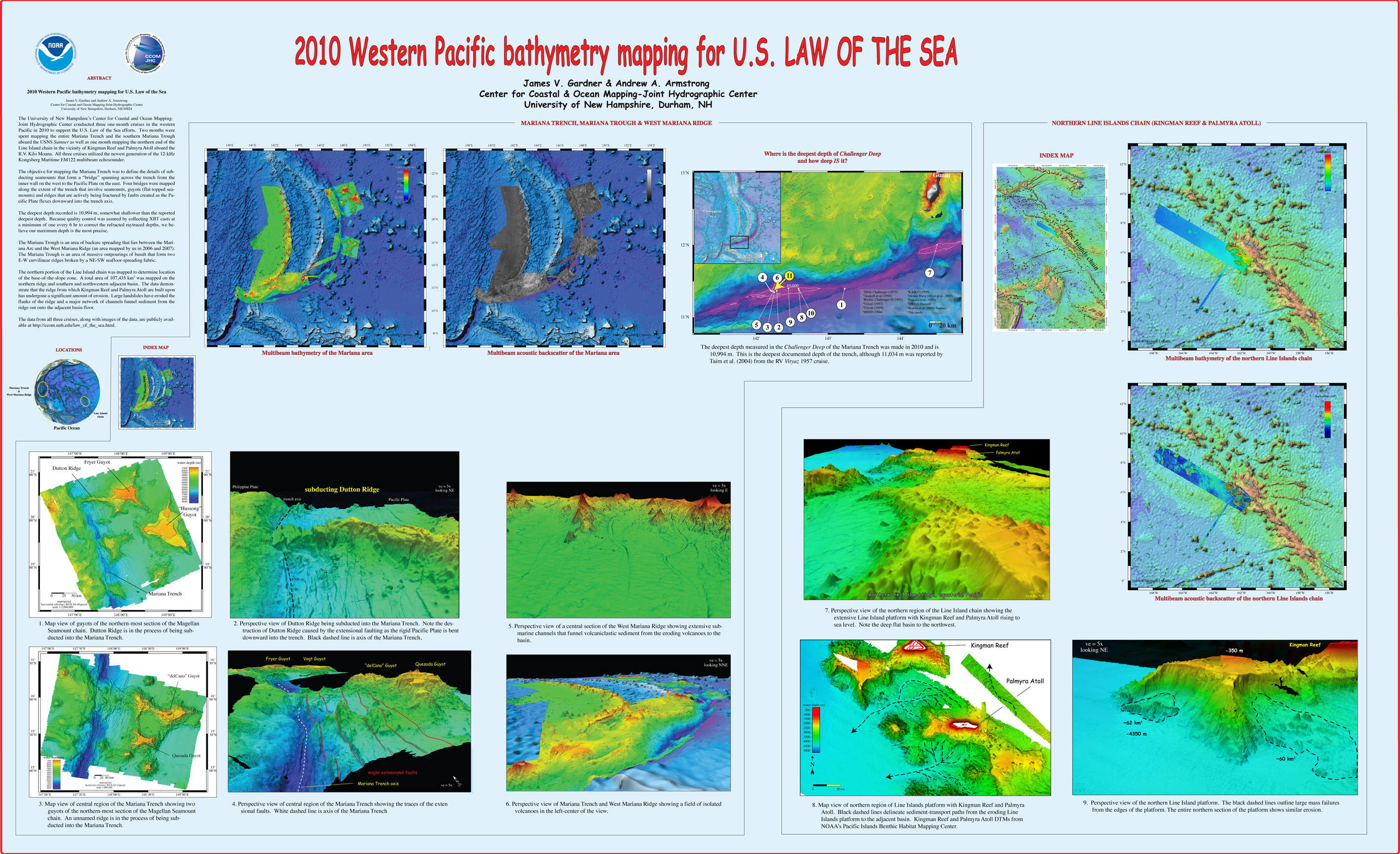
, “2010 Western Pacific bathymetry mapping for U.S. Law of the Sea”, U.S. Hydrographic Conference (US HYDRO). Tampa, FL, USA, 2011. Gardner_2011_USHYDRO_Western_Pacific_bathymetry_for_LOTS.jpg (3.5 MB)
, “3D Contour Perception for Flow Visualization”, ACM SIGGRAPH Symposium on Applied Perception in Graphics and Visualization (APGV). Boston, MA, USA, pp. 101-106, 2006. Ware-2006-SIGGRAPH-3D-Contour-Perception-for-Flow-Visualization.pdf (264.46 KB)
, “Acoustic and Geomorphological Signatures of Gas Seeps on the East Siberian Margin”, 2016 Graduate Research Conference. University of New Hampshire, Durham, NH, 2016.
, “Acoustic and optical observations of methane gas seeps in the Gulf of Mexico”, Proceedings of Meetings on Acoustics, vol. 19. 2013.
, “Acoustic backscattering observations from non-spherical gas bubbles with ka between 0.03 – 4”, Journal of the Acoustical Society of America, vol. 149(4). pp. 2504-2519, 2021.
, “Acoustic Calibration and Bathymetric Processing with an L-3 Klein 5410 Sidescan Sonar”, 2007. Glynn_2007_MS-Thesis_Acoustic_Calibration_and_Bathymetric_Processing_with_L-3_Klein_5410.pdf (3.54 MB)
, “Acoustic Detection and Quantification of Crude Oil”, University of New Hampshire, Durham, NH, 2019.
, “Acoustic Documentation of Temperate Odontocetes in the Bering and Chukchi Seas”, Marine Mammal Science, vol. 35. Society for Marine Mammalogy, pp. 1099-1111, 2019. Seger_et_al-2019-Marine_Mammal_Science.pdf (3.33 MB)
, “Acoustic estimates of methane gas flux from the seabed in a 6000 km2 region of the Northern Gulf of Mexico”, Geochemistry, Geophysics, Geosystems, vol. 15, no. 5. AGU, pp. 1911-1925, 2014. ggge20450.pdf (1.66 MB)
, “Acoustic Mapping of Mixed Layer Depth”, Ocean Science, vol. 14, 3. pp. 503-514, 2018.
, “Acoustic Mapping of Thermohaline Staircases in the Arctic Ocean”, Nature Scientific Reports, vol. 7:15192. Springer Nature, pp. 1-9, 2017. Stranne_et_al_2017_Acoustic_Mapping_of_Thermohaline_Staircases.pdf (3.65 MB)
, “Acoustic Measurements of a Controlled Gas Seep”, The Journal of the Acoustical Society of America, vol. 141(5). Acoustical Society of America, pp. 3524-3524, 2017.
, “Acoustic Methods for Mapping and Characterizing Submerged Aquatic Vegetation Using a Multibeam Echosounder”, University of New Hampshire, Durham, NH, 2019.
, “Acoustic Monitoring and Tracking of Natural Hydrocarbons Gas Bubbles Over the Course of a Year”, Science and Ocean Engineering Graduate Research Symposium. p. Virtual, 2021.
, “Acoustic observations and characterization of oceanic methane gas bubbles rising from the seabed”, The Journal of the Acoustical Society of America, vol. 140(4). Acoustical Society of America, pp. 3077-3077, 2016.
, “Acoustic observations of oil and gas in the northern Gulf of Mexico during and after the Deepwater Horizon spill”, 243rd Meeting of the American Chemical Society. 2012.
, “Acoustic observations of the deep scattering layer during the Deepwater Horizon oil spill”, 161st meeting of the Acoustical Society of America. Seattle, WA, USA, 2011.
, “Acoustic Predictors of Active Fluid Expulsion From a Hydrothermal Vent Field, Offshore Taupō Volcanic Zone, New Zealand”, Frontiers in Earth Science, vol. 9:785396. 2022.
, “The Acoustic Properties of Three Crude Oils at Oceanographically Relevant Temperatures and Pressures”, The Journal of the Acoustical Society of America, vol. 142(4). Acoustical Society of America, pp. 2506-2506, 2017.
, “Acoustic Ranging in a Dynamic, Multipath Environment”, 2008. Weirathmueller_2008_MS-Thesis_Acoustic_Ranging_in_Dynamic_Multipath_Environment.pdf (10.07 MB)
, “On Acoustic Reflection from Sand-Sized Water-Saturated Granular Media at MHz Frequencies: Measurements, Models and the Role of Speckle”, Journal of the Acoustical Society of America, vol. 148. pp. 3291-3304, 2020.
, “An Acoustic Scattering Model for Stratification Interfaces”, Journal of the Acoustical Society of America, vol. 150(6). Acoustic Society of America, pp. 4353-4361, 2021.
, “Acoustic Scattering of Large Wobbly Bubbles”, Bubbles 2017. Tromso, Norway, 2017.
, “Acoustic sensing of gas seeps in the deep ocean with split-beam echosounders”, 11th European Conference on Underwater Acoustics, Edinburgh, Scotland. 2012.
, “Acoustic Surface Backscatter vs Incidence Angle from Glacial Ice”, FEMME-2013. Boston, MA, USA, 2013.
, “Acoustically Relevant Properties of Four Crude Oils at Oceanographic Temperatures and Pressures”, The Journal of the Acoustical Society of America, vol. 144(5). Acoustical Society of America, 2018.
, “The Acoustics Environment of the Florida Manatee: Correlation of Noise and Level of Habitat Use”, Journal of the Acoustical Society of America, 2004.
, “Acquisizione marina dell’alto strutturale del Mt. Vercelli (Mar Tirreno Centrale) e del golfo di Napoli: descrizione dei rilievi e primi risultati”, GNGTS National Conference, vol. 3. Prato, Italy, Italy, pp. 517-518, 2010. Masetti_2010_3.2_cocchi.pdf (222.04 KB)
, “Active mud volcanoes on the continental slope of the Canadian Beaufort Sea”, Geochemistry, Geophysics, Geosystems, 2015.
, “Adding the “Where” to the “Who and What” — Considering the Seascape Can Help the Study of Biodiversity and Ecosystem Functioning”, 4th World Conference on Marine Biodiversity. p. Montreal (QC), Canada, 2018.
, “Adding Value to Broad-Scale Ocean Exploration Mapping Data Through Standardized Geomorphic Classification and Backscatter Data Analysis”, 2019 Fall Meeting, American Geophysical Union (AGU). p. San Francisco, CA, 2019.
, “ADEON Soundscape and Modeling Metadata Standard. Version 2.0 DRAFT”, TNO for ADEON Prime Contract No. M16PC00003, 2017.
, “Advancement in the Estimation of Gas Seep Flux from Echosounder Measurements”, 2017 US Hydrographic Conference. p. Galveston, TX, 2017.
, “Advances in Defining Fine- and Micro-Scale Pattern in Marine Plankton”, Aquatic Living Resources, vol. 16. Cambridge, pp. 131-136, 2003.
, “Advances in Nearshore Processes Research: Four Decades of Progress”, Shore and Beach, vol. 83(1). ASBPA, pp. 39-52, 2015. 19_holman_etal_2015.pdf (1.12 MB)
, “Advances in the study of marine mammal predator-prey interactions: a novel real-time visualization of independently collected echosounder data using GeoZui4D”, Society for Marine Mammalogy. Quebec City, Quebec, Canada, 2009. Arsenault_2009_SMM_Advances_in_the_study_of_marine_mammal_predator-prey_interactions_a_novel_real-time_visualization_of_independently_collected_echosounder_data_using_GeoZui4D.jpg (3.59 MB)
, “Advancing a Design for Trusted Community Bathymetry”, University of New Hampshire, Durham, NH, 2023. Tauriello-Thesis-2023.pdf (8.36 MB)
, “Africa Partnership Station”, Office of Naval Reasearch (ONR) , Durham, NH, USA, 2011.
, “Aggregation Methods Using Bathymetry Sources of Differing Subjective Reliabilities for Navigation Mapping”, Marine Geodesy, vol. 46. Taylor and Francis, pp. 99-128, 2023.
, “Airborne hyperspectral co-registration independent from attitude and positioning sensors”, Coastal GeoTools 2011. Myrtle Beach, SC, USA, 2011.
, “Airborne Lidar Bathymetry (ALB) Waveform Analysis for Bottom Return Characteristics”, SPIE Defense and Commercial Sensing. Baltimore, MD, 2016.
, “Airborne Lidar Bathymetry Beam Diagnostics Using an Underwater Optical Detector Array”, University of New Hampshire, Durham, NH, 2017. Matthew_Birkebak_FinalThesis.pdf (6.43 MB)
, “AIS Application-Specific Messages: Expectation and Reality”, Sea Technology, vol. 53, No. 3. p. 69, 2012.
, “AIS Binary Message Format Using XML to Provide Hydrographic-related Information”, U.S. Hydrographic Conference (US HYDRO). The Hydrographic Society of America, Norfolk, VA, 2007. Schwehr_07_USHYDRO_AIS_binary_format_using_xml_for_hydrographic_info.jpg (481.49 KB)
, “ALB Evaluation for NOAA charting requirements”, Hydro International, vol. 17(8). pp. 24-27, 2013. Imahori_et_al_2013_Hydro_Int.pdf (786.37 KB)
, “Algorithmic Implementation of the Triangle Test for the Validation of Charted Soundings”, 7th International Conference on Cartography & GIS. Bulgarian Cartographic Association, Sozopol, Bulgaria, pp. 569-576, 2018. Kastrisios_Calder_2018_Triangle_test_implementation_Proceedings_ICCGIS2018.pdf (1.49 MB)
, “Alpha / Mendeleev Ridge and Chukchi Borderland 40Ar/39Ar Geochronology and Geochemistry: Character of the First Submarine Intraplate Lavas Recovered from the Arctic Ocean”, EGU General Assembly 2015, vol. 17. Vienna, Austria, 2015.
, “Alternating Asymmetric Swimming Strokes in California Sea Lions”, 21st Biennial Conference on the Biology of Marine Mammals. Society for Marine Mammalogy, San Francisco, CA, 2015.
, “An alternative methodology (to the star symbols).”, International Hydrogarphic Organization, Monaco, 2020.
, “Alumni of the First Ten Years of Nippon Foundation/GEBCO Postgraduate Certificate in Ocean Bathymetry Training Program”, Fifth Extraordinary International Hydrographic Conference . Monaco, 2014.
, “Ambiguity of Underwater Color Measurement and Color-based Habitat Classification”, 4th Topical Meeting on Blue Photonics. Barcelona, Spain, 2015. BluePhotonics15-CCOM.pdf (133.62 KB)
, “Amplified Climate Sensitivity of Northern Greenland Fjords through Sea-Ice Damming”, Communications Earth & Environment, vol. 2(70). 2021.
, “Analysis of Acoustic Scattering Layers In and Around Petermann Fjord, Northwest Greenland”, University of New Hampshire, Durham, NH, 2022.
, “Analysis of Airborne Lidar Bathymetry (ALB) Bottom Return Waveforms”, 17th Annual JALBTCX Airborne Coastal Mapping and Charting Workshop. Silver Spring, MD, 2016.
, “Analysis of CLCS Recommendations in Light of Their Relevance to the Delineation of a United States Extended Continental Shelf (ECS) in the Arctic”, University of New Hampshire, Durham, NH, 2016. irish-onni-thesis.pdf (20.48 MB)
, “Analysis of the Radiated Sound Field of Deep Water Multibeam Echo Sounders for Return Intensity Calibration Using an Underwater Hydrophone Array”, The Journal of the Acoustical Society of America, vol. 142(2). Acoustical Society of America, pp. 2731-2731, 2017.
, “Analysis of the Radiated Soundfield of a Deep Water Multibeam Echosounder Using a Submerged Navy Hydrophone Array”, University of New Hampshire, Durham, NH, 2019.
, “Analysis of Uncertainty in Underwater Multiview Reconstruction”, University of New Hampshire, Durham, NH, 2018. kozlov-ms-2018.pdf (793.6 KB)
, “Analysis of Vibracores from the New Hampshire Continental Shelf from 1984 and 1988”, Department of Interior, Bureau of Ocean Energy Management, Marine Minerals Division, Sterling, VA, 2021.
, “Analytic solution for the forced mean cross-shore flow in the surf zone”, International Conference on Coastal Engineering (ICCE). ASCE, Hamburg, Hamburg, Germany, pp. 789-797, 2009. 20_lippmann_2009.pdf (1.02 MB)
, “Angular dependence of 12-kHz seafloor acoustic backscatter”, Journal of the Acoustical Society of America, vol. 90. Acoustical Society of America, Melville, NY, USA, pp. 522-531, 1991.
, “Angular Range Analysis of Acoustic Themes from Stanton Banks Ireland: A Link Between Visual Interpretation and Multibeam Echosounder Angular Signatures”, ACM Transactions on Applied Perception (TAP), vol. 70. Association for Computing Machinery (ACM), New York, NY, USA, pp. 1298-1304, 2009. Fonseca_2009_AA_Angular_range_analysis_of_acoustic_themes_from_Stanton_Banks_Ireland.pdf (2.61 MB)
, “Animated Versus Static Views of Steady Flow Patterns”, Proceedings of the ACM Symposium on Applied Perception. ACM, Anaheim, CA, pp. 77–84, 2016. ware-2016-acm-sap-proceedings.pdf (1.65 MB)
, “Application of color based semi-automatic computer analysis for underwater videomosaics: North Atlantic hard bottom case”, MAREANO Workshop. Trondheim, Norway, 2012.
, “Application of landscape mosaics for the biological quality assessment of subtidal macroalgae communities using the CFR index”, Deep Sea Research. 2013. Guinda-13-MosaicsAlgaeCommunities.pdf (1.02 MB)
, “Application of Landscape Mosaics for the Ecological Status Assesment of Subtidal Macroalgae Communities Using the CFR Index”, XIII International Symposium on Oceanography of the Bay of Biscay. Santander, Spain, 2012.
, “Application of the Coastal and Marine Ecological Classification Standard to Gosnold Seamount, North Atlantic Ocean”, in Seafloor Geomorphology as Benthic Habitat, 2nd nd ed., Elsevier, 2020, pp. 903-916.
, “Applications”, in Airborne Topographic Lidar Manual, Bethesda, Maryland: American Society for Photogrammetry and Remote Sensing (ASPRS), 2012, pp. 283-423.
, “Applications of Sonar Detection Uncertainty for Survey Quality Control and Data Processing”, Shallow Survey 2018. p. St. John's, NL, Canada, 2018. Masetti_SS2018_Sonar_Detection_Uncertainty_abstract.pdf (409.17 KB)
, “Applications of the Gulf of Maine Operational Forecast System to Enhance Spatio-Temporal Oceanographic Awareness for Ocean Mapping”, Frontiers in Marine Science, vol. 6:804. Frontiers Media, 2020.
, “Applying the Dynamic Soundscape to Estimates of Signal Detection”, 2nd Underwater Acoustics International Conference and Exhibition. Rhodes, Greece, 2014.
, “An Approach to the Perceptual Optimization of Complex Visualizations”, IEEE Transactions on Visualization and Computer Graphics, vol. 12. IEEE, Washington DC, Washington DC, USA, pp. 509-521, 2006. House_06_VCG_Perceptual_optimization_of_complex_visualizations.pdf (7.93 MB)
, “AR-ChUM: Augmented Reality Chart Update Mashup”, Oceans. IEEE Oceanic Engineering Society, Charleston, SC, 2018. OCEANS18-ARNav.pdf (1.61 MB)
, “The Arctic Continental Shelf and Its Evolving Morphologic Context”, in Challenges of the Changing Arctic: Continental Shelf, Navigation and Fisheries, vol. 19, Leiden, The Netherlands: Brill Nijhoff Press, 2016, pp. 17–41.
, “Arctic Marine Research: A U.S. Practitioner's Perspective”, in Arctic Science, International Law and Climate Change, Berlin, Germany: Springer Heidleberg, 2012, pp. 83-95.
, “Arctic Ocean Bathymetry: A Necessary Geospatial Framework”, ARCTIC, vol. 68, No. 5. Arctic Institute of North America, Calgary, Canada, pp. 41-47, 2015. jakobsson-mayer-monahan-arctic-2015.pdf (500.23 KB)
, “Arctic Ocean Bathymetry: A required geospatial framework”, The Arctic Observing Summit . 2013.
, “Arctic Ocean Glacial History”, Quaternary Science Reviews, vol. 92. pp. 42-67, 2014.
, “Arctic Ocean Physiography”, EOS Transactions, American Geophysical Union , vol. 83. San Francisco, CA, USA, pp. 0-0, 2002. Jakobsson_2002_AGU_Arctic_ocean_physiography.jpg (1.16 MB)
, “Are Manatees Modifying Their Vocalizations to Compensate for Noise?”, Journal of the Acoustical Society of America, 2006.


