Publications
, “Input/Output Devices and Interaction Techniques”, in The Computer Science and Engineering Handbook, 2nd ed., no. Chapman & Hall, CRC, Boca Raton, FL, USA: CRC Press, LLC, 2004.
, “Neural Modeling of Flow Rendering Effectiveness”, ACM Transactions on Applied Perception (TAP), vol. 7. Association for Computing Machinery (ACM), New York, NY, USA, pp. 1-15, 2010.
, “Detecting bedform migration in Portsmouth Harbor, New Hampshire, USA, on relatively short spatial and temporal scales”, American Geophysical Union (AGU). San Francisco, CA, USA, 2008.
, “Validating coastal flooding models using ALB-derived shorelines”, Canadian Hydrographic Conference (CHC). Victoria, British Columbia, Canada, 2008.
, “The International Bathymetric Chart of the Arctic Ocean (IBCAO): An Improved Morphological Framework for Oceanographic Investications”, EGS-AGU-AUG Joint Assembly. Nice, Nice, France, pp. 0-0, 2003.
, “Mosaicking Tools for Aerial Imagery from a LIDAR Bathymetry Survey”, International Hydrographic Review, vol. 9. Geomatics Information & Trading Center - GITC, Lemmers, Amsterdam, The Netherlands, pp. 35-44, 2008.
, “Site Survey of the Martha's Vineyard Coastal Observatory: Backscatter, Grain Size and Temporal Evolution of Rippled Scour Depressions”, EOS Transactions, American Geophysical Union , vol. 83. San Francisco, CA, USA, pp. 0-0, 2002.
, “On-Line Sea Beam Acoustic Imaging”, IEEE Oceans. Halifax, Nova Scotia, Canada, pp. 1197-1201, 1987.
, “Shoreline Mapping with Lidar and HSI-Derived Bathymetry”, GeoTech. Silver Springs, MD, USA, 2008.
, “International Research and Law of the Sea, Navigating A Course Toward Ocean Renewable Energy”, American Geophysical Union (AGU). Orlando, FL, USA, 2008.
, “Haptic Gdraw: A fun and Easy to Use 3D Haptically Enhanced Sculpting Program”, EuroHaptics (EH). Munich, Bavaria, Germany, pp. 436-439, 2004.
, “The Open Navigation Surface Project”, International Hydrographic Review, vol. 6. Geomatics Information & Trading Center - GITC, Lemmers, Amsterdam, The Netherlands, pp. 1-10, 2005.
, “Measurement of In Situ Acoustic Properties for the ONR Geoclutter Program”, University of New Hampshire (UNH), Center for Coastal and Ocean Mapping (CCOM)/Joint Hydrographic Center (JHC), 2004.
, “On the Brightness of Colours that Differ in Hue or Saturation”, ACM Computing Surveys, vol. 28. Association for Computing Machinery (ACM), New York, NY, USA, pp. 312-314, 1987.
, “AIS Binary Messages, Domain Examples and a Case for a XML Message Definition Language”, USCG Puget Sound VTS. Seattle, WA, USA, pp. 1-47, 2007.
, “A Comparison of the Automated Navigation Surface to Traditional Smooth Sheet Compilation”, Canadian Hydrographic Conference (CHC). Toronto, Ontario, Canada, pp. 0-0, 2002.
, “Trip Report for Nancy Foster IOCM Project 2010”, National Oceanic and Atmospheric Adminiatration (NOAA), Internal Report, 2010.
, “Robust Characterization of SHOALS Lidar Signals for Bottom Segmentation and Classification: A Combined Parameter-estimation and Curve Fitting Approach”, American Society for Photogrammetry and Remote Sensing (ASPRS). Denver, CO, USA, pp. 0-0, 2004.
, “New Standards for Providing Meteorological and Hydrographic Information via AIS Application-specific Messages”, International Hydrographic Review. Geomatics Information & Trading Center - GITC, Lemmers, Amsterdam, The Netherlands, pp. 37-44, 2010.
, “Clearance of Harbor Navigation Channels with High-resolution Bottom Surveys”, Acoustical Society of America (ASA). Salt Lake City, UT, USA, 2007.
, “Algorithm for dynamic disparity adjustment”, Society of Photographic Instrumentation Engineers (SPIE), vol. 2409. San Jose, CA, USA, pp. 150-156, 1995.
, “CHARTS Data Fusion: Multi-sensor Imagery Co-registration.”, Joint Airborne LIDAR Bathymetry Technical Center of Expertise Coastal Mapping and Charting Workshop (JALBTCX). Mobil, AL, USA, 2010.
, “Remote sensing of sediment characteristics by optimized echo-envelope matching”, Journal of the Acoustical Society of America, vol. 114. Acoustical Society of America, Melville, NY, USA, pp. 2727-2743, 2003.
, “Bathymetry and Acoustic Backscatter of the Mid and outer continental shelf, head of De Soto Canyon, Northeastern Gulf of Mexico”, U.S. Geological Survey (USGS), 2002.
, “Underwater behavior of humpback whales in a western North Atlantic foraging area”, Biennial Conference on the Biology of Marine Mammals (CBMM). San Diego, CA, USA, 2005.
, “ECDIS Development Laboratory and Navigation Technology Demonstration Center”, IEEE Oceans. Honolulu, HI, USA, pp. 0-0, 2001.
, “Dissolution of biogenic ooze over basement edifices in the equatorial Pacific with implications for hydrothermal ventilation of the oceanic crust”, Geology, vol. 35. The Geological Society of America (GSA), pp. 679-682, 2007.
, “Accuracy of the Spatial Representation of the Seafloor with Bathymetric Sidescan Sonars”, Marine Geophysical Researches, vol. 16. Springer Publisher, New York, NY, USA, pp. 407-425, 1994.
, “Waveform characterization, clustering and segmentation of SHOALS”, Joint Airborne LIDAR Bathymetry Technical Center of Expertise Coastal Mapping and Charting Workshop (JALBTCX). St. Andrews, New Brunswick, Canada, pp. 0-0, 2004.
, “A Time Comparison of Computer-Assisted and Manual Bathymetric Processing”, International Hydrographic Review, vol. 5. Geomatics Information & Trading Center - GITC, Lemmers, Amsterdam, The Netherlands, pp. 10-23, 2004.
, “Processing Klein 5410 Data from Trawlex-01, Alaska Fisheries Science Center”, National Oceanic and Atmospheric Adminiatration (NOAA), National Ocean Service (NOS) / Office of Response and Restoration (ORR), 2003.
, “Interocular Transfer of a Visual After-Effect in Normal and Stereoblind Humans”, Journal of Physiology, vol. 236. The Physiological Society, pp. 707-721, 1974.
, “Long Range Side Scan Sonar for Fishery Research”, Oceanology International (OI). London, London, UK, 2006.
, “Investigation of Seabed Fishing Impacts on Benthic Structure using Multi-beam Sonar, Sidescan Sonar, and Video”, ICES Journal of Marine Science, vol. 64. Elsevier, New York, NY, USA, pp. 1053-1065, 2007.
, “Development and Analysis of a Bathymetric Database for Great Bay Estuary, New Hampshire”, New Hampshire Department of Environmental Services (DES), New Hampshire Coastal Program (NHCP), 2009.
, “The target strength of the northern right whale (Eubalaena glacialis)”, Journal of the Acoustical Society of America, vol. 105. Acoustical Society of America, Melville, NY, USA, pp. 0-992, 1999.
, “Measuring Ambient Ocean Bubble Fields Uusing a Multibeam Sonar”, Acoustical Society of America (ASA). Austin, TX, USA, pp. 0-0, 2003.
, “Effects of a Large Fishing Closure on Benthic Communitites in the Western Gulf of Maine: Recovery from the Effects of Gillnets and Otter Trawls”, Fisheries Bulletin, vol. 107. National Marine Fisheries Service Scientific Publications Office, pp. 308-317, 2009.
, Mapping and Characterizing Subtidal Oyster Reefs Using Acoustic Techniques, Underwater Videography and Quadrat Counts, no. P.W. Barnes & J.P. Thomas. Bethesda, MD, USA: American Fisheries Society, 2003.
, “Visualizing Object Oriented Software in Three Dimensions”, Centre for Adbanced Studies on Collaborative Research (CASCON). Toronto, Ontario, Canada, pp. 612-620, 1993.
, “Physiography of the Eastern Mendocino Ridge, NE Pacific Ocean”, American Geophysical Union (AGU). San Francisco, CA, USA, 2009.
, “On the Effect of Random Errors in Gridded Bathymetric Compilations”, Journal of Geophysical Research, vol. 107. American Geophysical Union , Washington DC, Washington DC, USA, pp. 1-11, 2002.
, “Sedimentation in Canada Basin, Western Arctic”, American Geophysical Union (AGU). San Francisco, CA, USA, 2010.
, “Comparison Between Physical Sediment Samples and Grain-size Estimates from GeoCoder”, International Hydrographic Conference (HYDRO). Cape Town, Western Cape, South Africa, 2009.
, “Detecting Compaction Disequilibrium with Anisotropy of Magnetic Susceptibility”, Geochemistry Geophysics Geosystems, vol. 7. American Geophysical Union , Washington DC, Washington DC, USA, pp. 0-18, 2006.
, “ABYSS-Lite: A Radar Altimeter for Bathymetry, Geodesy and Mesoscale Oceanography, A Mission Concept Submitted to the NRC Decadal Survey”, University of New Hampshire (UNH), Center for Coastal and Ocean Mapping (CCOM)/Joint Hydrographic Center (JHC), 2005.
, “Automatic Processing of Bathymetric Data from Multibeam Echosounders”, EOS Transactions, American Geophysical Union , vol. 82. San Francisco, CA, USA, pp. 0-0, 2001.
, “History and Activities of GEBCO Guiding Committee”, Symposium on Application of Marine Geophysical Data and Undersea Features. Incheon, Sudogwon, Korea, pp. 4-13, 2007.
, “Measurements of ambient bubble populations with a multibeam sonar”, Acoustical Society of America (ASA). St. Andrews, New Brunswick, Canada, pp. 0-0, 2002.
, “Determination of the Foot of the Continental Slope as the Point of Maximum Change in the Gradient at Its Base”, in Legal and Scientific Aspects of Continental Shelf Limits, 8th ed., no. M.H Nordquist, J.N. Moore & T. Heider, Leiden, South Holland, The Netherlands: Martinus Nijhoff legacy_publishers, 2004, pp. 91-120.
, “Approaches and Requirements of Quantitative Comparison of the Multibeam Sonar Benthic Acoustic Backscatter”, Shallow Water Survey Conference (SWS). Durham, NH, USA, 2008.
, “Geometric Corrections on Sidescan Sonar Images Based on Bathymetry. Application with SeaMARC II and Sea Beam Data”, Marine Geophysical Researches, vol. 16. Springer Publisher, New York, NY, USA, pp. 365-383, 1994.
, “New Paradigms for Hydrographic Data Processing and Products”, International Conference on High-Resolution Survey in Shallow Water (HRSSW). St. Andrews, New Brunswick, Canada, pp. 0-0, 2003.
, “Lake Tahoe's submerged record of active faulting is characteristic of the Basin and Range”, Geological Society of America (GSA), vol. 33. Cedar City, UT, USA, pp. 0-0, 2002.
, “Multiple Sound Source Synchronizer for Seafloor Surveying”, Offshore Technology Conference (OTC). Houston, TX, USA, pp. 0-8, 1988.
, “New Approach to Autoextraction and Attribution of Airport Obstructions from LIDAR Data”, Transportation Research Board (TRB) . Washington DC, Washington DC, USA, 2008.
, “Lidar Obstruction Surveys and Imagery Data for Airport Applications”, International Conference on Transport Infrastructure (ICTI). Beijing, Beijing, China, 2008.
, “Protocols for Calibrating Multibeam Sonar”, Journal of the Acoustical Society of America, vol. 117. Acoustical Society of America, Melville, NY, USA, pp. 2013-2027, 2005.
, “DNews Configuration for Private Ship to Shore Usenet Communication”, National Oceanic and Atmospheric Adminiatration (NOAA), National Ocean Service (NOS) / Office of Response and Restoration (ORR), 2004.
, “State of the Art in Swath Bathymetry Survey Systems”, International Hydrographic Review, vol. 65. Geomatics Information & Trading Center - GITC, Lemmers, Amsterdam, The Netherlands, pp. 0-0, 1988.
, “Specification Format for AIS Binary Messages for Providing Hydrographic-related Information”, U.S. Hydrographic Conference (US HYDRO). Norfolk, VA, USA, pp. 0-21, 2007.
, “Mapping Benthic Habitat at Various scales in the Olympic National Marine Sanctuary, WA”, National Shellfisheries Association (NSA). New Orleans, LA, USA, pp. 0-0, 2002.
, “Pleistocene Stratigraphy and Paleoenvironmental Variation from Lomonosov Ridge Sediments Central Artic Ocean”, Global and Planetary Change, vol. 31. Elsevier, New York, NY, USA, pp. 1-21, 2001.
, “Assimilation of Airborne Imagery with a Wave Model for Bathymetric Estimation”, Journal of Coastal Research. Coastal Education & Research Foundation, Inc. [CERF], West Palm Beach, FL, USA, pp. 1-28, 2010.
, “Correções radiométricas dos dados sonográficos da Bacia de Campos (Radiometric Corrections of sidescan sonar data from Campos Basin.)”, Brazilian Symposium of Remote Sensing (BSRS). Salvador, Bahia, Brazil, pp. 0-0, 1996.
, “Modeling uncertainty in the lidar-derived NOAA shoreline”, Joint Airborne LIDAR Bathymetry Technical Center of Expertise Coastal Mapping and Charting Workshop (JALBTCX). Mobil, AL, USA, 2010.
, “The Importance of Stereo, Eye Coupled Perspective and Touch for Eye-Hand Coordination”, Presence: Teleoperators and Virtual Environments. MIT Press, Cambridge, MA, USA, pp. 0-0, 2003.
, “Multibeam Mapping of the West Florida Shelf, Gulf of Mexico”, U.S. Geological Survey (USGS), 2002.
, “Geodatabase Development to Support Hyperspectral Imagery Exploitation”, IEEE International Geoscience and Remote Sensing Symposium (IGARSS). Honolulu, HI, USA, 2010.
, “The Use of Multibeam Sonars to Image Bubbly Shipwakes”, Underwater Acoustic Measurements: Technologies & Results (UAM). Heraklion, Crete, Greece, pp. 0-0, 2005.
, “Geophysical Insights into the Transition Fault Debate: Propagating Strike Slip in Response to Stalling Yakutat Block Subduction in the Gulf of Alaska”, Geology, vol. 35. The Geological Society of America (GSA), pp. 763-766, 2007.
, “e-Navigation, ECDIS and MIOs: At Present and in the Future”, eNavigation Conference. Seattle, WA, USA, 2008.
, “Seabed Characterization Using Normalized Backscatter Data by Best Estimated Grazing Angles”, International Symposium on Underwater Technology (UT). St. Andrews, New Brunswick, Canada, pp. 153-160, 2004.
, “Pseudospectral time-domain modeling of non-Rayleigh reverberation: synthesis and statistical analysis of a sidescan sonar image of sand ripples”, IEEE Journal of Oceanic Engineering, vol. 29. IEEE, Washington DC, Washington DC, USA, pp. 317-329, 2004.
, “Bathymetry and Selected Perspective Views of 6 Reef and Coastal Areas in Northern Lake Michigan”, U.S. Geological Survey (USGS), 2003.
, “Perception of Subjective Lines, Surfaces and Volumes in Three-dimensional Constructions”, Leonardo, vol. 11. The International Society for the Arts, Sciences, and Technology, pp. 111-114, 1978.
, “Multi resolution quality improvement for patch-bases texture synthesis in wavelet domain”, International Association of Science and Technology for Development (IASTED). Honolulu, HI, USA, 2006.
, “Seafloor Habitat Mapping: Considering Techniques for Expansion of Spatial Scales”, Workshop on Deep-Seabed Survey Technologies. Bergen, Bergen, Norway, pp. 0-0, 2001.
, “Results from Canadian User Needs Survey”, Canadian Coast Guard and Ministry of Transport, 2010.
, “A study of Haptic Linear and Pie Menus in a 3D Fish Tank VR Environment”, International Symposium on Haptics Interfaces for Virtual Environments and Teleoperator Systems (HAPTICS). Chicago, IL, USA, pp. 224-231, 2004.
, “Measurements of Acoustic Backscatter and Density of Captive Atlantic Cod with Synchronized 300-kHz Multibeam and 120-kHz Split-Beam Echosounders”, ICES Journal of Marine Science, vol. 66. Elsevier, New York, NY, USA, pp. 1303-1309, 2009.
, The Electronic Chart. Functions, Potential and Limitations of a New Navigation System. Lemmers, Amsterdam, The Netherlands: Geomatics Information & Trading Center - GITC, 2006, p. 293.
, “Environmental Response Management Application (ERMA) - Web-based GIS Data Display and Management System for Oil Spill Planning and Environmental Response”, Coastal Geotools. Myrtle Beach, SC, USA, 2009.
, “Comparison of In-situ Compressional Wave Speed and Attenuation Measurements to Biot-stoll Model Predictions”, Journal of the Acoustical Society of America, vol. 112. Acoustical Society of America, Melville, NY, USA, pp. 2254-2254, 2002.
, “Petrography and U-pb, Detrital Zircon Geochronology of Metasedimentary Strata Dredged from the Chukchi Borderland, Amerasia Basin, Arctic Ocean”, American Geophysical Union (AGU). San Francisco, CA, USA, 2010.
, “High-resolution Delineation of Acoustically Homogeneous Areas in Multibeam Backscatter Maps”, Gulf of Maine Symposium. St. Andrews, New Brunswick, Canada, 2009.
, “The Optimization of Visualization of Complex Phenomena”, IEEE Visualization (VIS). Minneapolis, MN, USA, pp. 87-94, 2005.
, “Layout for Visualizing Large Software Structures in 3D”, Interanational Conference on Visual Information Systems (VISUAL). San Diego, CA, USA, pp. 215-223, 1997.
, “NOAA's OKEANOS EXPLORER and Telepresence Technology”, Marine Technology Reporter, vol. 49. Maritime Activity Reports, Inc., pp. 24-33, 2006.
, “Memory Intensive Statistical Algorithms for Multibeam Bathymetric Data”, Computers and Geosciences, vol. 17. Elsevier, New York, NY, USA, pp. 985-993, 1991.
, “Electronic Navigational Charts and Marine Information Objects for Navigation Safety and Marine Environmental Protection”, Commission on Hydrography Conference (CHC). Veracruz, Veracruz, Mexico, 2007.
, “Challenges of Collecting Law of the Sea Data in the Arctic: The Arctic and Law of the Sea”, in International Energy Policy, the Arctic and the Law of the Sea, 9th ed., no. M.H. Nordquist, J.N. Moore & A.S. Skaridov, Leiden, South Holland, The Netherlands: Martinus Nijhoff legacy_publishers, 2005, pp. 125-140.
, “Lidar-Derived National Shoreline: Empirical and Stochastic Uncertainty Analyses”, Journal of Coastal Research, vol. 62. Coastal Education & Research Foundation, Inc. [CERF], West Palm Beach, FL, USA, pp. 62-74, 2011.
, “Inland Navigation Technology '09 - Digital Technology Impact on Safety and Efficiency”, U.S. Army Engineer Research and Development Center, Coastal and Hydrologic Laboratory, 2009.
, “The Integrated Seafloor: Efficient Multi Sensor Processing and Visualization Techniques for Seafloor Mapping Data”, International Hydrographic Conference (HYDRO). Christchurch, Christchurch, New Zealand, pp. 0-0, 2003.
, “Clustered Scatterers: The Effect on the Mean Acoustic Field”, ACM Transactions on Applied Perception (TAP), vol. 123. Association for Computing Machinery (ACM), New York, NY, USA, pp. 3897-3898, 2008.
, “Resolving the Ripples (and a Mine): High-Resolution Multibeam Survey of Martha's Vineyard ONR Mine Burial Program Field Area”, EOS Transactions, American Geophysical Union , vol. 83. San Francisco, CA, USA, pp. 0-0, 2002.
, “Modifications and Improvements to the Sea Beam System on Board R/V Thomas Washington”, IEEE Oceans. St. Andrews, New Brunswick, Canada, pp. 372-378, 1988.
, “Okeanos Explorer - Aligning Today's Technology to a New Paradigm of Ocean Exploration”, FEMME - Kongsberg (users conference). Lisbon, Lisbon, Portugal, 2009.
, “Using Lidar in Obstruction Chart Surveys”, Transportation Research Board (TRB) . Washington DC, Washington DC, USA, 2004.
, “Hydrographic Interoperability Report”, Marine Magnetics, 2004.
, “Analysis of Lidar Leaf Penetration Indices for Selected Plant Species in a Coastal Marsh and Correlation with Terrain Elevation Accuracy”, American Society for Photogrammetry and Remote Sensing (ASPRS). Baltimore, MD, USA, 2009.
, “Adaptive Noise Canceling Applied to Sea Beam Sidelobe Interference Rejection”, IEEE Journal of Oceanic Engineering, vol. 13. IEEE, Washington DC, Washington DC, USA, pp. 70-76, 1988.
, “Combining Single Frequency Multibeam with Multifrequency Singlebeam Sonars: An Example with Atlantic Herring”, Conference Underwater Acoustic Measurements: Technologies and Results. Crete, Greece, Greece, pp. 0-0, 2007.
, “A Reappraisal of Deepwater Reefs Along the NW Florida Outer Continental Shelf”, UC Santa Cruz Marine Sciences Seminar . St. Andrews, New Brunswick, Canada, pp. 0-0, 2002.
, “Animation Using Behaviour Functions”, in Visual Languages and Application, no. Tadeo Ichikarva, Erland Jungert and Robert Korfhage, Bingly, West Yorkshire, UK: Emerald Group Publishing Limited, 1990.
, “Huge Iceage Lakes in Russia”, Journal of Quaternary Science, vol. 16. Wiley InterScience, pp. 773-777, 2001.
, “Bathymetry Retrieval from Hyperspectral Imagery in the Very Shallow Water Limit: a Case Study from the 2007 Virginia Coast Reserve (VCR’07) Multi-Sensor Campaign”, Marine Geodesy, vol. 33. Taylor & Francis, pp. 53-75, 2010.
, “Vertical Object Identification in Full-Waveform Topographic Lidar Data”, Joint Airborne LIDAR Bathymetry Technical Center of Expertise Coastal Mapping and Charting Workshop (JALBTCX). Seattle, WA, USA, 2007.
, “Structuring the First Course In HCI”, Conference on the Teaching of Computing. Dublin, Leinster, Ireland, pp. 69-73, 1996.
, “The Importance of Physical and Biogenic Structure to Juvenile Fishes on the Shallow Inner Continental Shelf”, Estuaries, vol. 26. The Estuarine Research Federation, pp. 12-20, 2003.
, “Multibeam Mapping of Selected Areas of the Outer Continental Shelf, Northwestern Gulf of Mexico - Data, Images and GIS”, U.S. Geological Survey (USGS), 2002.
, “4D Multimodal Visualization and Analysis of Seafloor Vents and Plumes”, Canadian Hydrographic Conference (CHC). Quebec City, Quebec, Canada, pp. 1-2, 2010.
, “Close-range acoustic scattering from mud volcanoes”, Acoustical Society of America (ASA). St. Andrews, New Brunswick, Canada, pp. 0-0, 2005.
, “Robust Automatic Multi-beam Bathymetric Processing”, U.S. Hydrographic Conference (US HYDRO). Norfolk, VA, USA, pp. 0-20, 2001.
, “Encoding AIS Binary Messages in XML Format for Providing Hydrographic-related Information”, International Hydrographic Review, vol. 8. Geomatics Information & Trading Center - GITC, Lemmers, Amsterdam, The Netherlands, pp. 36-57, 2007.
, “1-6.3-CoastPilotDataStructure”, International Hydrographic Organization, Monaco, 2015. NIPW 1-6.3-CoastPilotDataStructure.pdf (6.83 MB)
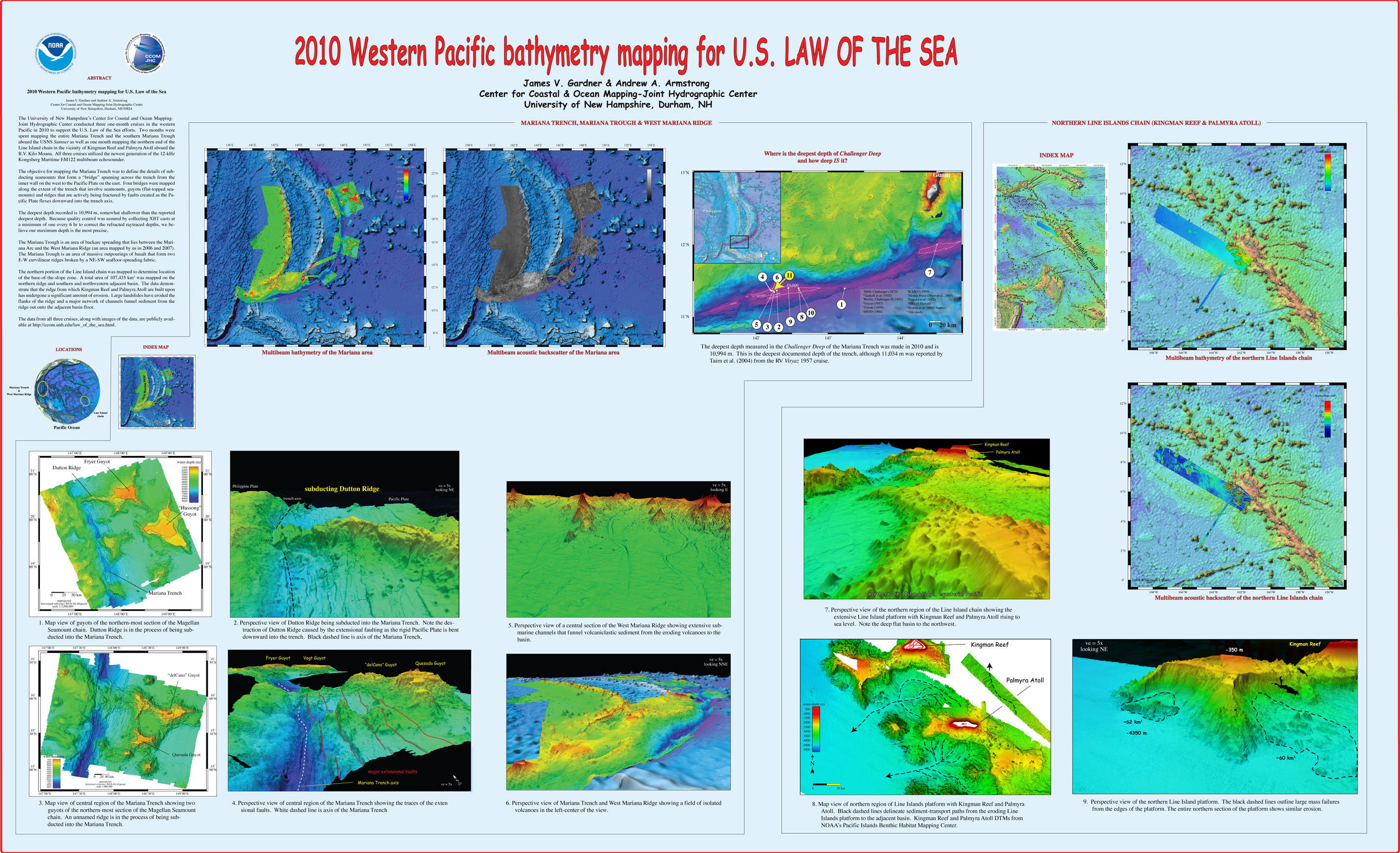
, “2010 Western Pacific bathymetry mapping for U.S. Law of the Sea”, U.S. Hydrographic Conference (US HYDRO). Tampa, FL, USA, 2011. Gardner_2011_USHYDRO_Western_Pacific_bathymetry_for_LOTS.jpg (3.5 MB)
, “3D Contour Perception for Flow Visualization”, ACM SIGGRAPH Symposium on Applied Perception in Graphics and Visualization (APGV). Boston, MA, USA, pp. 101-106, 2006. Ware-2006-SIGGRAPH-3D-Contour-Perception-for-Flow-Visualization.pdf (264.46 KB)
, “Acoustic and Geomorphological Signatures of Gas Seeps on the East Siberian Margin”, 2016 Graduate Research Conference. University of New Hampshire, Durham, NH, 2016.
, “Acoustic and optical observations of methane gas seeps in the Gulf of Mexico”, Proceedings of Meetings on Acoustics, vol. 19. 2013.
, “Acoustic backscattering observations from non-spherical gas bubbles with ka between 0.03 – 4”, Journal of the Acoustical Society of America, vol. 149(4). pp. 2504-2519, 2021.
, “Acoustic Calibration and Bathymetric Processing with an L-3 Klein 5410 Sidescan Sonar”, 2007. Glynn_2007_MS-Thesis_Acoustic_Calibration_and_Bathymetric_Processing_with_L-3_Klein_5410.pdf (3.54 MB)
, “Acoustic Detection and Quantification of Crude Oil”, University of New Hampshire, Durham, NH, 2019.
, “Acoustic Documentation of Temperate Odontocetes in the Bering and Chukchi Seas”, Marine Mammal Science, vol. 35. Society for Marine Mammalogy, pp. 1099-1111, 2019. Seger_et_al-2019-Marine_Mammal_Science.pdf (3.33 MB)
, “Acoustic estimates of methane gas flux from the seabed in a 6000 km2 region of the Northern Gulf of Mexico”, Geochemistry, Geophysics, Geosystems, vol. 15, no. 5. AGU, pp. 1911-1925, 2014. ggge20450.pdf (1.66 MB)
, “Acoustic Mapping of Mixed Layer Depth”, Ocean Science, vol. 14, 3. pp. 503-514, 2018.
, “Acoustic Mapping of Thermohaline Staircases in the Arctic Ocean”, Nature Scientific Reports, vol. 7:15192. Springer Nature, pp. 1-9, 2017. Stranne_et_al_2017_Acoustic_Mapping_of_Thermohaline_Staircases.pdf (3.65 MB)
, “Acoustic Measurements of a Controlled Gas Seep”, The Journal of the Acoustical Society of America, vol. 141(5). Acoustical Society of America, pp. 3524-3524, 2017.
, “Acoustic Methods for Mapping and Characterizing Submerged Aquatic Vegetation Using a Multibeam Echosounder”, University of New Hampshire, Durham, NH, 2019.
, “Acoustic Monitoring and Tracking of Natural Hydrocarbons Gas Bubbles Over the Course of a Year”, Science and Ocean Engineering Graduate Research Symposium. p. Virtual, 2021.
, “Acoustic observations and characterization of oceanic methane gas bubbles rising from the seabed”, The Journal of the Acoustical Society of America, vol. 140(4). Acoustical Society of America, pp. 3077-3077, 2016.
, “Acoustic observations of oil and gas in the northern Gulf of Mexico during and after the Deepwater Horizon spill”, 243rd Meeting of the American Chemical Society. 2012.
, “Acoustic observations of the deep scattering layer during the Deepwater Horizon oil spill”, 161st meeting of the Acoustical Society of America. Seattle, WA, USA, 2011.
, “Acoustic Predictors of Active Fluid Expulsion From a Hydrothermal Vent Field, Offshore Taupō Volcanic Zone, New Zealand”, Frontiers in Earth Science, vol. 9:785396. 2022.
, “The Acoustic Properties of Three Crude Oils at Oceanographically Relevant Temperatures and Pressures”, The Journal of the Acoustical Society of America, vol. 142(4). Acoustical Society of America, pp. 2506-2506, 2017.
, “Acoustic Ranging in a Dynamic, Multipath Environment”, 2008. Weirathmueller_2008_MS-Thesis_Acoustic_Ranging_in_Dynamic_Multipath_Environment.pdf (10.07 MB)
, “On Acoustic Reflection from Sand-Sized Water-Saturated Granular Media at MHz Frequencies: Measurements, Models and the Role of Speckle”, Journal of the Acoustical Society of America, vol. 148. pp. 3291-3304, 2020.
, “An Acoustic Scattering Model for Stratification Interfaces”, Journal of the Acoustical Society of America, vol. 150(6). Acoustic Society of America, pp. 4353-4361, 2021.
, “Acoustic Scattering of Large Wobbly Bubbles”, Bubbles 2017. Tromso, Norway, 2017.
, “Acoustic sensing of gas seeps in the deep ocean with split-beam echosounders”, 11th European Conference on Underwater Acoustics, Edinburgh, Scotland. 2012.
, “Acoustic Surface Backscatter vs Incidence Angle from Glacial Ice”, FEMME-2013. Boston, MA, USA, 2013.
, “Acoustically Relevant Properties of Four Crude Oils at Oceanographic Temperatures and Pressures”, The Journal of the Acoustical Society of America, vol. 144(5). Acoustical Society of America, 2018.
, “The Acoustics Environment of the Florida Manatee: Correlation of Noise and Level of Habitat Use”, Journal of the Acoustical Society of America, 2004.
, “Acquisizione marina dell’alto strutturale del Mt. Vercelli (Mar Tirreno Centrale) e del golfo di Napoli: descrizione dei rilievi e primi risultati”, GNGTS National Conference, vol. 3. Prato, Italy, Italy, pp. 517-518, 2010. Masetti_2010_3.2_cocchi.pdf (222.04 KB)
, “Active mud volcanoes on the continental slope of the Canadian Beaufort Sea”, Geochemistry, Geophysics, Geosystems, 2015.
, “Adding the “Where” to the “Who and What” — Considering the Seascape Can Help the Study of Biodiversity and Ecosystem Functioning”, 4th World Conference on Marine Biodiversity. p. Montreal (QC), Canada, 2018.
, “Adding Value to Broad-Scale Ocean Exploration Mapping Data Through Standardized Geomorphic Classification and Backscatter Data Analysis”, 2019 Fall Meeting, American Geophysical Union (AGU). p. San Francisco, CA, 2019.
, “ADEON Soundscape and Modeling Metadata Standard. Version 2.0 DRAFT”, TNO for ADEON Prime Contract No. M16PC00003, 2017.
, “Advancement in the Estimation of Gas Seep Flux from Echosounder Measurements”, 2017 US Hydrographic Conference. p. Galveston, TX, 2017.
, “Advances in Defining Fine- and Micro-Scale Pattern in Marine Plankton”, Aquatic Living Resources, vol. 16. Cambridge, pp. 131-136, 2003.
, “Advances in Nearshore Processes Research: Four Decades of Progress”, Shore and Beach, vol. 83(1). ASBPA, pp. 39-52, 2015. 19_holman_etal_2015.pdf (1.12 MB)
, “Advances in the study of marine mammal predator-prey interactions: a novel real-time visualization of independently collected echosounder data using GeoZui4D”, Society for Marine Mammalogy. Quebec City, Quebec, Canada, 2009. Arsenault_2009_SMM_Advances_in_the_study_of_marine_mammal_predator-prey_interactions_a_novel_real-time_visualization_of_independently_collected_echosounder_data_using_GeoZui4D.jpg (3.59 MB)
, “Advancing a Design for Trusted Community Bathymetry”, University of New Hampshire, Durham, NH, 2023. Tauriello-Thesis-2023.pdf (8.36 MB)
, “Africa Partnership Station”, Office of Naval Reasearch (ONR) , Durham, NH, USA, 2011.
, “Aggregation Methods Using Bathymetry Sources of Differing Subjective Reliabilities for Navigation Mapping”, Marine Geodesy, vol. 46. Taylor and Francis, pp. 99-128, 2023.
, “Airborne hyperspectral co-registration independent from attitude and positioning sensors”, Coastal GeoTools 2011. Myrtle Beach, SC, USA, 2011.
, “Airborne Lidar Bathymetry (ALB) Waveform Analysis for Bottom Return Characteristics”, SPIE Defense and Commercial Sensing. Baltimore, MD, 2016.
, “Airborne Lidar Bathymetry Beam Diagnostics Using an Underwater Optical Detector Array”, University of New Hampshire, Durham, NH, 2017. Matthew_Birkebak_FinalThesis.pdf (6.43 MB)
, “AIS Application-Specific Messages: Expectation and Reality”, Sea Technology, vol. 53, No. 3. p. 69, 2012.
, “AIS Binary Message Format Using XML to Provide Hydrographic-related Information”, U.S. Hydrographic Conference (US HYDRO). The Hydrographic Society of America, Norfolk, VA, 2007. Schwehr_07_USHYDRO_AIS_binary_format_using_xml_for_hydrographic_info.jpg (481.49 KB)
, “ALB Evaluation for NOAA charting requirements”, Hydro International, vol. 17(8). pp. 24-27, 2013. Imahori_et_al_2013_Hydro_Int.pdf (786.37 KB)
, “Algorithmic Implementation of the Triangle Test for the Validation of Charted Soundings”, 7th International Conference on Cartography & GIS. Bulgarian Cartographic Association, Sozopol, Bulgaria, pp. 569-576, 2018. Kastrisios_Calder_2018_Triangle_test_implementation_Proceedings_ICCGIS2018.pdf (1.49 MB)
, “Alpha / Mendeleev Ridge and Chukchi Borderland 40Ar/39Ar Geochronology and Geochemistry: Character of the First Submarine Intraplate Lavas Recovered from the Arctic Ocean”, EGU General Assembly 2015, vol. 17. Vienna, Austria, 2015.
, “Alternating Asymmetric Swimming Strokes in California Sea Lions”, 21st Biennial Conference on the Biology of Marine Mammals. Society for Marine Mammalogy, San Francisco, CA, 2015.
, “An alternative methodology (to the star symbols).”, International Hydrogarphic Organization, Monaco, 2020.
, “Alumni of the First Ten Years of Nippon Foundation/GEBCO Postgraduate Certificate in Ocean Bathymetry Training Program”, Fifth Extraordinary International Hydrographic Conference . Monaco, 2014.
, “Ambiguity of Underwater Color Measurement and Color-based Habitat Classification”, 4th Topical Meeting on Blue Photonics. Barcelona, Spain, 2015. BluePhotonics15-CCOM.pdf (133.62 KB)
, “Amplified Climate Sensitivity of Northern Greenland Fjords through Sea-Ice Damming”, Communications Earth & Environment, vol. 2(70). 2021.
, “Analysis of Acoustic Scattering Layers In and Around Petermann Fjord, Northwest Greenland”, University of New Hampshire, Durham, NH, 2022.
, “Analysis of Airborne Lidar Bathymetry (ALB) Bottom Return Waveforms”, 17th Annual JALBTCX Airborne Coastal Mapping and Charting Workshop. Silver Spring, MD, 2016.
, “Analysis of CLCS Recommendations in Light of Their Relevance to the Delineation of a United States Extended Continental Shelf (ECS) in the Arctic”, University of New Hampshire, Durham, NH, 2016. irish-onni-thesis.pdf (20.48 MB)
, “Analysis of the Radiated Sound Field of Deep Water Multibeam Echo Sounders for Return Intensity Calibration Using an Underwater Hydrophone Array”, The Journal of the Acoustical Society of America, vol. 142(2). Acoustical Society of America, pp. 2731-2731, 2017.
, “Analysis of the Radiated Soundfield of a Deep Water Multibeam Echosounder Using a Submerged Navy Hydrophone Array”, University of New Hampshire, Durham, NH, 2019.
, “Analysis of Uncertainty in Underwater Multiview Reconstruction”, University of New Hampshire, Durham, NH, 2018. kozlov-ms-2018.pdf (793.6 KB)
, “Analysis of Vibracores from the New Hampshire Continental Shelf from 1984 and 1988”, Department of Interior, Bureau of Ocean Energy Management, Marine Minerals Division, Sterling, VA, 2021.
, “Analytic solution for the forced mean cross-shore flow in the surf zone”, International Conference on Coastal Engineering (ICCE). ASCE, Hamburg, Hamburg, Germany, pp. 789-797, 2009. 20_lippmann_2009.pdf (1.02 MB)
, “Angular dependence of 12-kHz seafloor acoustic backscatter”, Journal of the Acoustical Society of America, vol. 90. Acoustical Society of America, Melville, NY, USA, pp. 522-531, 1991.
, “Angular Range Analysis of Acoustic Themes from Stanton Banks Ireland: A Link Between Visual Interpretation and Multibeam Echosounder Angular Signatures”, ACM Transactions on Applied Perception (TAP), vol. 70. Association for Computing Machinery (ACM), New York, NY, USA, pp. 1298-1304, 2009. Fonseca_2009_AA_Angular_range_analysis_of_acoustic_themes_from_Stanton_Banks_Ireland.pdf (2.61 MB)
, “Animated Versus Static Views of Steady Flow Patterns”, Proceedings of the ACM Symposium on Applied Perception. ACM, Anaheim, CA, pp. 77–84, 2016. ware-2016-acm-sap-proceedings.pdf (1.65 MB)
, “Application of color based semi-automatic computer analysis for underwater videomosaics: North Atlantic hard bottom case”, MAREANO Workshop. Trondheim, Norway, 2012.
, “Application of landscape mosaics for the biological quality assessment of subtidal macroalgae communities using the CFR index”, Deep Sea Research. 2013. Guinda-13-MosaicsAlgaeCommunities.pdf (1.02 MB)
, “Application of Landscape Mosaics for the Ecological Status Assesment of Subtidal Macroalgae Communities Using the CFR Index”, XIII International Symposium on Oceanography of the Bay of Biscay. Santander, Spain, 2012.
, “Application of the Coastal and Marine Ecological Classification Standard to Gosnold Seamount, North Atlantic Ocean”, in Seafloor Geomorphology as Benthic Habitat, 2nd nd ed., Elsevier, 2020, pp. 903-916.
, “Applications”, in Airborne Topographic Lidar Manual, Bethesda, Maryland: American Society for Photogrammetry and Remote Sensing (ASPRS), 2012, pp. 283-423.
, “Applications of Sonar Detection Uncertainty for Survey Quality Control and Data Processing”, Shallow Survey 2018. p. St. John's, NL, Canada, 2018. Masetti_SS2018_Sonar_Detection_Uncertainty_abstract.pdf (409.17 KB)
, “Applications of the Gulf of Maine Operational Forecast System to Enhance Spatio-Temporal Oceanographic Awareness for Ocean Mapping”, Frontiers in Marine Science, vol. 6:804. Frontiers Media, 2020.
, “Applying the Dynamic Soundscape to Estimates of Signal Detection”, 2nd Underwater Acoustics International Conference and Exhibition. Rhodes, Greece, 2014.
, “An Approach to the Perceptual Optimization of Complex Visualizations”, IEEE Transactions on Visualization and Computer Graphics, vol. 12. IEEE, Washington DC, Washington DC, USA, pp. 509-521, 2006. House_06_VCG_Perceptual_optimization_of_complex_visualizations.pdf (7.93 MB)
, “AR-ChUM: Augmented Reality Chart Update Mashup”, Oceans. IEEE Oceanic Engineering Society, Charleston, SC, 2018. OCEANS18-ARNav.pdf (1.61 MB)
, “The Arctic Continental Shelf and Its Evolving Morphologic Context”, in Challenges of the Changing Arctic: Continental Shelf, Navigation and Fisheries, vol. 19, Leiden, The Netherlands: Brill Nijhoff Press, 2016, pp. 17–41.
, “Arctic Marine Research: A U.S. Practitioner's Perspective”, in Arctic Science, International Law and Climate Change, Berlin, Germany: Springer Heidleberg, 2012, pp. 83-95.
, “Arctic Ocean Bathymetry: A Necessary Geospatial Framework”, ARCTIC, vol. 68, No. 5. Arctic Institute of North America, Calgary, Canada, pp. 41-47, 2015. jakobsson-mayer-monahan-arctic-2015.pdf (500.23 KB)
, “Arctic Ocean Bathymetry: A required geospatial framework”, The Arctic Observing Summit . 2013.
, “Arctic Ocean Glacial History”, Quaternary Science Reviews, vol. 92. pp. 42-67, 2014.
, “Arctic Ocean Physiography”, EOS Transactions, American Geophysical Union , vol. 83. San Francisco, CA, USA, pp. 0-0, 2002. Jakobsson_2002_AGU_Arctic_ocean_physiography.jpg (1.16 MB)
, “Are Manatees Modifying Their Vocalizations to Compensate for Noise?”, Journal of the Acoustical Society of America, 2006.


