Publications
, “Potential for Non-Conventional Use of Split-Beam Phase Data in Bottom Detection”, University of New Hampshire, Durham, NH, 2020. Leonardo_Gomes_de_Araujo_MSc_Thesis.pdf (7.25 MB)
, “Obtaining a Reference for Calibrating Broadband Multibeam Seabed Backscatter”, University of New Hampshire, Durham, NH, 2020.
, “Linearity Tests of a Multibeam Echosounder”, University of New Hampshire, Durham, NH, 2010.
, “ZOC / QoBD Matrices”, International Hydrographic Organization, 2022.
, “Using Moored Arrays and Hyperspectral Aerial Imagery to Develop Nutrient Criteria for New Hampshire's Estuaries”, The New Hampshire Estuaries Project, Piscataqua Regional Estuary Program, 2009. Morrison_2010_Report_Using_Moored_Arrays_and_Hyperspecral_Areial_Imagery_to_Develop_Nutrient_Criteria_NH_Estuaries.pdf (2.49 MB)
, “U.S. Law of the Sea cruises to map sections of the Mariana Trench and the eastern and southern insular margins of Guam and the Northern Mariana Islands”, University of New Hampshire (UNH), Center for Coastal and Ocean Mapping (CCOM)/Joint Hydrographic Center (JHC), 2010. Gardner_2010_cruise_report_SU10-1_Marianas.pdf (4.88 MB)
, “U.S. Law of the Sea Cruise to Map the Western Insular Margin and 2500-m Isobath of Guam and the Northern Mariana Islands. Cruise Report”, University of New Hampshire (UNH), Center for Coastal and Ocean Mapping (CCOM)/Joint Hydrographic Center (JHC), 2007. Gardner_07_cruise_report_BD07-1.pdf (2.54 MB)
, “U.S. Law of the Sea Cruise to Map the Southern Flank of the Kingman Reef-Palmyra Atoll section of the Line Islands, Equatorial Pacific Ocean”, Center for Coastal and Ocean Mapping / Joint Hydrographic Center, Durham, NH, 2010. Gardner_2010_cruise_report_KM1009_Kingman-Palmyra.pdf (4.12 MB)
, “U.S. Law of the Sea Cruise to Map the Foot of the Slope of the Northeast U.S. Atlantic Continental Margin: Leg 7”, Center for Coastal and Ocean Mapping / Joint Hydrographic Center, Durham, NH, 2012. cruise-report-RB12-1-Atlantic.pdf (2.26 MB)
, “U.S. Law of the Sea Cruise to Map the Foot of the Slope of the Northeast U.S. Atlantic Continental Margin: Leg 6”, University of New Hampshire (UNH), Center for Coastal and Ocean Mapping (CCOM)/Joint Hydrographic Center (JHC), 2008. Calder_08_cruise_report_Atlantic_KNOX17RR.pdf (7.4 MB)
, “U.S. Law of the Sea Cruise to Map the Foot of the Slope and 2500-m Isobath of the Northeast US Atlantic Continental Margin: Legs 1, 2 and 3. Cruise Report”, University of New Hampshire (UNH), Center for Coastal and Ocean Mapping (CCOM)/Joint Hydrographic Center (JHC), 2004. Gardner_04_cruise_report_HEN04-1.pdf (2.24 MB)
, “U.S. Law of the Sea Cruise to Map the Foot of the Slope and 2500-m Isobath of the Gulf of Alaska Continental Margin. Cruise Report”, University of New Hampshire (UNH), Center for Coastal and Ocean Mapping (CCOM)/Joint Hydrographic Center (JHC), 2005. Gardner_05_cruise_report_KM0514.pdf (9.58 MB)
, “U.S. Law of the Sea Cruise to Map the Foot of the Slope and 2500-m Isobath of the Northeast U.S. Atlantic Continental Margin: Legs 4 and 5. Cruise Report”, University of New Hampshire (UNH), Center for Coastal and Ocean Mapping (CCOM)/Joint Hydrographic Center (JHC), 2005. Cartwright_05_cruise_report_PF05-1.pdf (1.59 MB)
, “U.S. Law of the Sea Cruise to Map the Foot of the Slope and 2500-m Isobath of the Florida Escarpment and Sigsbee Escarpment, Northern Gulf of Mexico Continental Marg. Cruise Report”, University of New Hampshire (UNH), Center for Coastal and Ocean Mapping (CCOM)/Joint Hydrographic Center (JHC), 2007. Gardner_07_cruise_report_NR07-1.pdf (21.74 MB)
, “U.S. Law of the Sea Cruise to Map the Eastern Mendocino Ridge, Eastern Pacific Ocean”, University of New Hampshire, Durham, NH, 2009. Gardner_09_cruise_report_EX0903_Mendocino.pdf (2.19 MB)
, “U.S. Law of the Sea Cruise to Complete the Mapping of Necker Ridge, Central Pacific Ocean”, Center for Coastal and Ocean Mapping (CCOM)/Joint Hydrographic Center (JHC), 2011. Gardner_2011_Cruise_Report_KM1121_NeckerRidge.pdf (2.31 MB)
, “U.S. Extended Continental Shelf Cruise to Map Gulf of Alaska, Eastern Pacific”, Center for Coastal and Ocean Mapping / Joint Hydrographic Center, Durham, NH, 2018. KM1811-Cruise-Report.pdf (3.46 MB)
, “U.S. Extended Continental Shelf Cruise to Map Gaps in Kela and Karin Ridges, Johnston Atoll, Equatorial Pacific Ocean”, CCOM/JHC, Durham, NH, 2014. lots-cruise-report-km14-17-johnston-atoll.pdf (24.43 MB)
, “R/V Sikuliaq EM302 & EM710 Multibeam Echosounder System Shipboard Acceptance Tests - SKQ201400L3”, 2014.
, “RICAMAR2013: Rilievi per la caratterizzazione dell'ambiente marino nel Golfo di Pozzuoli. Rapporto sull'attività. 13 - 31 maggio 2013”, Rapporti Tecnici INGV (ISSN 2039-7941), 2013. Masetti_2013_Report_RICAMAR_INGV.pdf (3.45 MB)
, “RICAMAR2013: Rilievi per la caratterizzazione dell'ambiente marino nel Golfo di Pozzuoli. Rapporto sull'attività. 13 - 31 maggio 2013”, Rapporti Tecnici INGV (ISSN 2039-7941), 2013. Masetti_2013_Report_RICAMAR_INGV.pdf (3.45 MB)
, “Report on the LOTS Cruise to Map Foot of the Slope and 2500-m Isobath of Bowers Ridge and Beringian Margin, Bering Sea. Cruise Report”, University of New Hampshire (UNH), Center for Coastal and Ocean Mapping (CCOM)/Joint Hydrographic Center (JHC), 2003. Gardner_03_cruise_report_DA0301.pdf (8.01 MB)
, “Report on the 2018 Rapid Assessment Survey of Introduced, Cryptogenic, and Native Marine Species at New England Marinas Massachusetts to Maine”, Commonwealth of Massachusetts, Boston, MA, 2020.
, “Report on the 2018 Rapid Assessment Survey of Introduced, Cryptogenic, and Native Marine Species at New England Marinas Massachusetts to Maine”, Commonwealth of Massachusetts, Boston, MA, 2020.
, “Report on the 2018 Rapid Assessment Survey of Introduced, Cryptogenic, and Native Marine Species at New England Marinas Massachusetts to Maine”, Commonwealth of Massachusetts, Boston, MA, 2020.
, “Report on the 2013 Rapid Assessment Survey (RAS) of Marine Species at New England Bays and Harbors”, Massachussetts Office of Coastal Management (CZM) , Boston, MA, United States, 2014.
, “Report on the 2010 rapid assessment survey of marine species at New England floating docks and rocky shores.”, Office of Coastal Zone Management, Boston, Massachusetts, 2013.
, “Report on the 2010 rapid assessment survey of marine species at New England floating docks and rocky shores.”, Office of Coastal Zone Management, Boston, Massachusetts, 2013.
, “Report on the 2010 rapid assessment survey of marine species at New England floating docks and rocky shores.”, Office of Coastal Zone Management, Boston, Massachusetts, 2013.
, “Rapporto sulle attivita’ oceanografiche, geochimiche, geologiche, geofisiche e di campionamento durante la crociera PANA13 con ITS Magnaghi : Panarea, I.Eolie, Tirreno S.Orientale, 2013-06-02- 2013-06-08.”, RAPPORTI ISMAR, Roma, Italy, 2014.
, “Ocean Sound Essential Ocean Variable Implementation Plan”, Partnership for Observation of the Global Ocean (POGO), 2023.
, “New Views of the Gulf of Alaska Margin Mapped for UNCLOS Applications”, University of New Hampshire (UNH), Center for Coastal and Ocean Mapping (CCOM)/Joint Hydrographic Center (JHC), 2005. Mayer_05_Gulf_of_Alaska_Margin_Mapped_for_UNCLOS_applications.pdf (65.49 KB)
, “Law of the Sea Cruise to Map the Western Insular Margin and 2500-m Isobath of Guam and the Northern Mariana Islands. Cruise Report”, University of New Hampshire (UNH), Center for Coastal and Ocean Mapping (CCOM)/Joint Hydrographic Center (JHC), 2006. Gardner_06_cruise_report_BD06-1.pdf (2.02 MB)
, “E/V Nautilus - EM302 Multibeam Echosounder System Quality Assurance Review - NA079, May 1-6, 2017”, 2017.
, “Blue Carbon: The role of healthy oceans in binding carbon”, 2010. Nellemann_2010_BlueCarbon_book.pdf (17.54 MB)
, “Benefits of Geographic Information Systems for State and Regional Ocean Management”, Oregon State University , Corvallis, OR, USA, 1999.
, “Bathymetric Terrain Model of the Atlantic Margin for Marine Geological Investigations, Version 2.0”, U.S. Geological Survey (USGS), Woods Hole, MA, 2016. ofr2012-1266_V2_Clean_23Feb16.pdf (1.21 MB)
, “Bathymetric terrain model of the Atlantic margin for marine geological investigations.”, 2013. USGS OFR 2012-1266.pdf (316.55 KB)
, “Baseline Survey of Habitats and Resources of the North Mill Pond”, New Hampshire Department of Environmental Services (DES), New Hampshire Coastal Program (NHCP), 2009.
, “Bathymetry and Selected Perspective Views of 6 Reef and Coastal Areas in Northern Lake Michigan”, U.S. Geological Survey (USGS), 2003.
, “Predicted Seafloor Facies of Central Santa Monica Bay, California”, U.S. Geological Survey (USGS), 2004.
, “Bathymetry and Selected Perspective Views Offshore Greater Los Angeles, CA”, U.S. Geological Survey (USGS), 2002.
, “UNCLOS Mapping of Marianas Western Margin, Technical Report”, University of New Hampshire (UNH), Center for Coastal and Ocean Mapping (CCOM)/Joint Hydrographic Center (JHC), 2006.
, “Multibeam Mapping of the Los Angeles, California Margin”, U.S. Geological Survey (USGS), 2002.
, “Multibeam Mapping of the Pinnacles Region, Gulf of Mexico”, U.S. Geological Survey (USGS), 2002.
, “Bathymetry and Acoustic Backscatter of the Mid and Outer Continental Shelf, Head of De Soto Canyon, Northeastern Gulf of Mexico Data, Images, and GIS”, U.S. Geological Survey (USGS), 2003.
, “Crater Lake Revealed - Investigations I-2790”, U.S. Geological Survey (USGS), 2003.
, “Visualizing the Geology of Lake Trout Spawning Sites: Northern Lake Michigan”, U.S. Geological Survey (USGS), 2004.
, “Los Angeles and San Diego Margin High-resolution Multibeam Bathymetry and Backscatter Data”, U.S. Geological Survey (USGS), 2004.
, “Bathymetry and Acoustic Backscatter of Selected Areas of the Outer Continental Shelf, Northwestern Gulf of Mexico”, U.S. Geological Survey (USGS), 2002.
, “Bathymetry and Acoustic Backscatter of the Mid and outer continental shelf, head of De Soto Canyon, Northeastern Gulf of Mexico”, U.S. Geological Survey (USGS), 2002.
, “Multibeam Mapping of the West Florida Shelf, Gulf of Mexico”, U.S. Geological Survey (USGS), 2002.
, “Multibeam Mapping of Selected Areas of the Outer Continental Shelf, Northwestern Gulf of Mexico - Data, Images and GIS”, U.S. Geological Survey (USGS), 2002.
, “Towards an Optic-Based Citizen Science Solution for Mapping Habitats in Coastal Areas”, Québec Ocean Annual General Meeting. Riviere du Loup (QC), Canada, 2017.
, “Resolving the Ripples (and a Mine): High-Resolution Multibeam Survey of Martha's Vineyard ONR Mine Burial Program Field Area”, 2002 Fall Meeting, American Geophysical Union. American Geophysical Union , San Francisco, CA, 2002. Mayer_2002_AGU_Resolving_ripples_Marthas_vineyard_ONR_mine_burial_program.jpg (1.1 MB)
, “Preliminary Polar Sea Trials of Nereid-UI: A Remotely Operated Underwater Vehicle for Oceanographic Access Under Ice”, 2014 Fall Meeting, American Geophysical Union (AGU). San Francisco, CA, 2014.
, “Preliminary Polar Sea Trials of Nereid-UI: A Remotely Operated Underwater Vehicle for Oceanographic Access Under Ice”, 2014 Fall Meeting, American Geophysical Union (AGU). San Francisco, CA, 2014.
, “Optimal Image Blending for Underwater Mosaics”, Oceans 2006. IEEE, Boston, MA, 2006. Gu_IEEE_2006_Optimal_image_blending_for_underwater_mosaics.jpg (952.33 KB)
, “Observations of Bedform Evolution in an Inlet”, Ocean Sciences. Salt Lake City, UT, United States, 2012.
, “The Mariana Trench: A New View Based on Multibeam Echosounding”, American Geophysical Union, Fall Meeting. San Francisco, CA, United States, 2011.
, “Mapping and Geomorphic Characterization of the Vast Cold-Water Coral Mounds of the Blake Plateau”, 8th International Symposium Deep-Sea Corals. Edinburgh, Scotland, UK, 2023. ISDSC8_Sowers_et_al_Poster_Final.pdf (4.02 MB)
, “Lake Tahoe Bottom Characteristics Extracted from SHOALS Lidar Waveform Data and Compared to Backscatter Data From a Multibeam Echo Sounder”, 2002 Fall Meeting, American Geophysical Union. American Geophysical Union , San Francisco, CA, 2002. Elston_2002_AGU_Lake_tahoe_bottom_chars_from_shoals_lidar.jpg (766 KB)
, “In Situ Measurement of Geoacoustic Properties: An Example From the ONR Mine Burial Program, Martha's Vineyard Coastal Observatory”, 2002 Fall Meeting, American Geophysical Union. American Geophysical Union , San Francisco, CA, 2002. Kraft_2002_AGU_In-Situ_measurment_geozcoustic_sediment_properties.jpg (1.02 MB)
, “High-resolution Mapping of Offshore and Onshore Glaciogenic Features in Melville Bay, Northwestern Greenland”, 2014 Fall Meeting, American Geophysical Union (AGU). San Francisco, CA, 2014.
, “High-resolution Mapping of Offshore and Onshore Glaciogenic Features in Melville Bay, Northwestern Greenland”, 2014 Fall Meeting, American Geophysical Union (AGU). San Francisco, CA, 2014.
, “GEBCO Visual Library, Proof of Concept”, International Bathymetric Science Day. Tokyo, Tokyo, Japan, pp. 1-1, 2008. monahan_08_ISBD2.png (476.56 KB)
, ““Flexible Imaging Device” — Packaging an Optic-Based Citizen Science Solution for Mapping Habitats in Coastal Areas”, Sentinelle Nord Annual Meeting. Université Laval, Quebec City, Quebec, Canada, 2018.
, “E/V Nautilus: Seafloor Exploration and Mapping in the National Marine Sanctuary of American Samoa”, 2019 Fall Meeting of the American Geophysical Union. American Geophysical Union , San Francisco, CA, 2019.
, “CCOM-JHC Summer Hydro 2012: A High-Res Survey Under 12 Flags”, Eighth Annual GEBCO Bathymetric Science Day. Venice, Italy, 2013. ccom_poster_gebco_2013.pdf (730.59 KB)
, “CCOM-JHC Summer Hydro 2012: A High-Res Survey Under 12 Flags”, Eighth Annual GEBCO Bathymetric Science Day. Venice, Italy, 2013. ccom_poster_gebco_2013.pdf (730.59 KB)
, “Arctic Ocean Physiography”, EOS Transactions, American Geophysical Union , vol. 83. San Francisco, CA, USA, pp. 0-0, 2002. Jakobsson_2002_AGU_Arctic_ocean_physiography.jpg (1.16 MB)
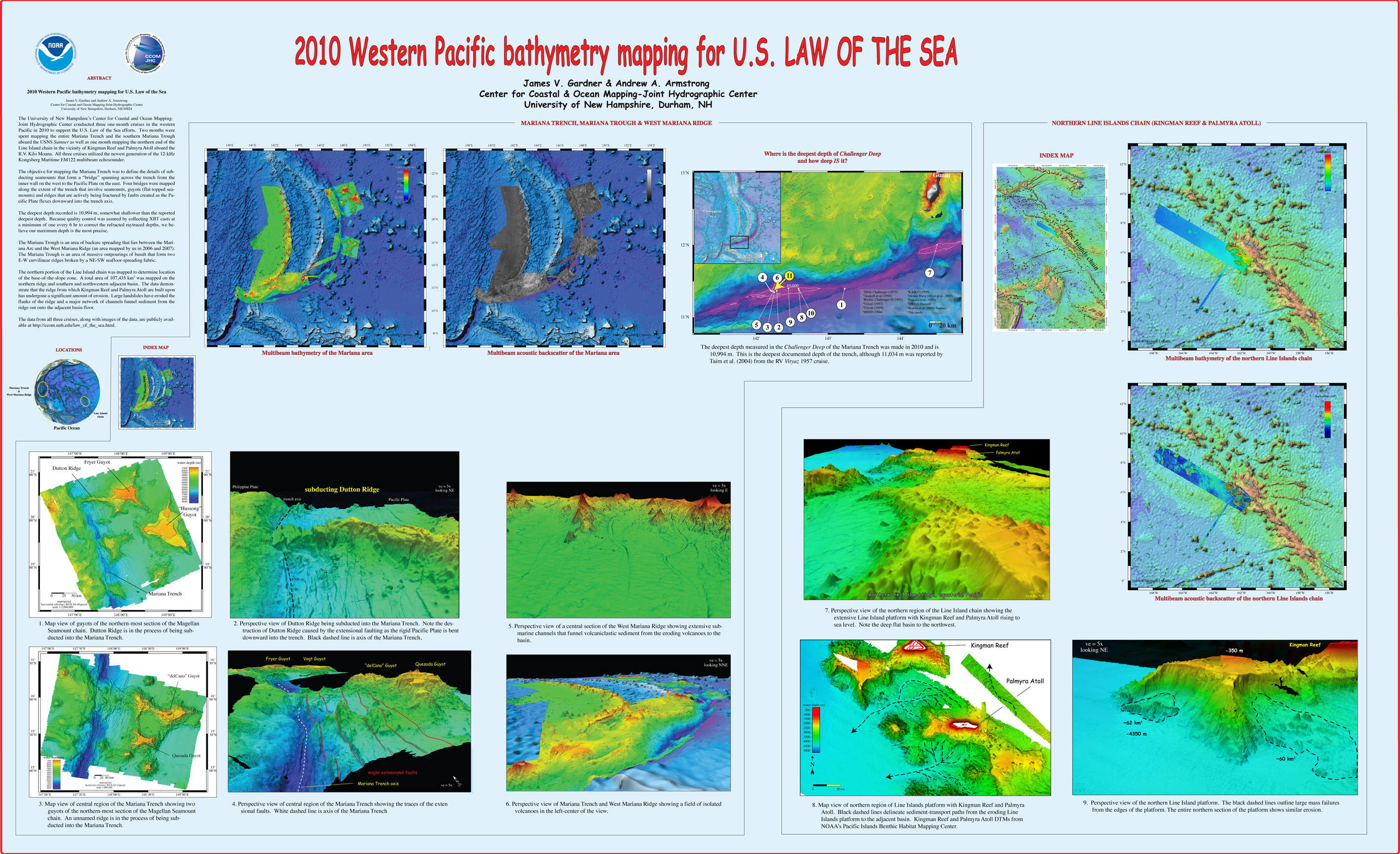
, “2010 Western Pacific bathymetry mapping for U.S. Law of the Sea”, U.S. Hydrographic Conference (US HYDRO). Tampa, FL, USA, 2011. Gardner_2011_USHYDRO_Western_Pacific_bathymetry_for_LOTS.jpg (3.5 MB)
, “The World of S-100: Data Standards for Navigation Systems and Beyond”, OceanPredict. 2019.
, “Working with Video to Improve Deep-Sea Habitat Characterization”, Oceanography, vol. 31, No.1, Supplement. The Oceanographic Society, pp. 64-67, 2018. WorkingWithVideo_Oceanography31-1-2018_supplement.pdf (1.75 MB)
, “What Controls Submarine Channel Development and the Morphology of Deltas Entering Deep-Water Fjords?”, Earth Surface Processes and Landforms, vol. 44(2). John Wiley and Sons Ltd. , pp. 535-551, 2019.
, “The West Mariana Ridge, Western Pacific Ocean: Geomorphology and Processes from New Multibeam Data”, Geological Society of America Bulletin (GSAB), vol. 122. The Geological Society of America (GSA), pp. 1378-1388, 2010. Gardner_2010_GSAB_West_Mariana_Ridge_Geomorphology_and_processes_from_new_multibeam_data.pdf (4.28 MB)
, “Using high-resolution multibeam bathymetry to identify seafloor surface rupture along the Palos Verdes fault complex in offshore southern California”, Geology, vol. 28. Geological Society of America, Boulder, CO, pp. 587-590, 2000. Marlow et al. 2000.pdf (671.14 KB)
, “US UNCLOS Multibeam Data: The Processing of Multibeam Bathymetry and Backcatter”, Hydro International, vol. 8. Geomatics Information & Trading Center - GITC, Lemmers, Amsterdam, The Netherlands, pp. 14-17, 2008. Fonseca_al_2008_hydro_intl.pdf (1.42 MB)
, “U.S. Law of the Sea Mapping”, Hydro International, vol. 9. Geomatics Information & Trading Center - GITC, Lemmers, Amsterdam, The Netherlands, pp. 42-45, 2005. Gardner_05_Hydro_US_Law_of_the_Sea_Mapping.pdf (16.23 MB)
, “Towards Automating the Nautical Chart Generalization Workflow”, Geo-spatial Information Science. Taylor & Francis, pp. 1-26, 2024.
, “Toward the Development of a Marine Administration System Based on International Standards”, International Journal of Geo-Information , vol. 6(7). MDPI, 2017.
, “Time-Lapse Seafloor Surveys Reveal How Turbidity Currents and Internal Tides in Monterey Canyon Interact With the Seabed at Centimeter-Scale”, Journal of Geophysical Research: Earth Surface, vol. 128 (4). American Geophysical Union, 2023.
, “Surface Seiches in Flathead Lake”, Hydrology and Earth Systems Sciences, vol. 19. Copernicus Publications, pp. 2605-2615, 2015. 18_kirillin_etal_2015.pdf (1.33 MB)
, “Submarine landslides of San Pedro Sea Valley, southwest of Long Beach, California”, Marine Geology, vol. 203. Elsevier, New York, NY, USA, pp. 261-268, 2004. Bohannon-Gardner-2004.pdf (891.57 KB)
, “Standardized Geomorphic Classification of Seafloor Within the United States Atlantic Canyons and Continental Margin”, Frontiers in Marine Science, vol. 7(9). pp. 1-9, 2020.
, “The Soundscape of the Anthropocene Ocean”, Science, vol. 371 (6526). 2021.
, “Sound Speed Manager: An Open-Source Application to Manage Sound Speed Profiles”, International Hydrographic Review, vol. 17. International Hydrographic Bureau, Monaco, pp. 31-40, 2017. IHR_May2017_SoundSpeedManager.pdf (836.81 KB)
, “So, how deep is the Mariana Trench?”, Marine Geodesy, vol. 37, No. 1. Geological Society of America, Boulder, CO, pp. 1-13, 2014. Gardner-et-al-2014-Challenger-Deep.pdf (572.85 KB)
, “The significance of pockmarks to understanding fluid flow processes and geohazards”, Geofluids, vol. 2. pp. 127-136, 2002.
, “Shelf-edge Deltas and Drowned Barrier-island Complexes on the Northwest Florida Outer Continental Shelf”, Geomorphology, vol. 64. Elsevier, New York, NY, USA, pp. 133-166, 2005. Gardner-et-al-NWFlaPUBLISHED.pdf (8.56 MB)
, “Sedimentary processes of the lower Monterey Fan channel and channel-mouth lobe”, Marine Geology, vol. 206. pp. 181-198, 2004.
, “Searching for Shipwrecks in Thunder Bay National Marine Sanctuary”, Oceanography, vol. 33(1). The Oceanography Society, pp. 32-33, 2020.
, “Searching for Shipwrecks in Thunder Bay National Marine Sanctuary”, Oceanography, vol. 33(1). The Oceanography Society, pp. 32-33, 2020.
, “Seamounts, Submarine Channels, and New Discoveries”, Journal of Ocean Technology, vol. 10, No. 3. Fisheries and Marine Institute of Memorial University of Newfoundland, St. John's, Newfoundland, Canada, pp. 1-14, 2015. Armstrong-et-al-2015-ocean-tech.pdf (557.4 KB)
, “Seafloor Mapping with a Cylindrical Array”, The Journal of the Acoustical Society of America, vol. 141(5). Acoustical Society of America, 2017.
, “Seafloor Mapping In The Arctic:Support For a Potential US Extended Continental Shelf”, International Hydrographic Review, vol. 3. Geomatics Information & Trading Center - GITC, Lemmers, Amsterdam, The Netherlands, pp. 14-23, 2010. Mayer_2010_IHR_Sea_Floor_Mapping_In_The_Arctic.pdf (684.1 KB)
, “The Seafloor: A Key Factor in Lidar Bottom Detection”, IEEE Transactions on Geoscience and Remote Sensing, vol. 49. IEEE, Washington DC, Washington DC, USA, pp. 1150-1157, 2011. Peeri_2010_IEEE_The_Seafloor-A_key_factor_in_Lidar_bottom_detection.pdf (801.32 KB)
, “Seabed characterization on the New Jersey middle and outer shelf: Correlability and spatial variably of seafloor sediment properties”, Marine Geology, vol. 209. Elsevier, New York, NY, USA, pp. 147-172, 2004. Goff_2004_MG_Seabed_characterization_New_Jersey_middle_outer_shelf.pdf (1.12 MB)
, “Seabed characterization on the New Jersey middle and outer shelf: Correlability and spatial variably of seafloor sediment properties”, Marine Geology, vol. 209. Elsevier, New York, NY, USA, pp. 147-172, 2004. Goff_2004_MG_Seabed_characterization_New_Jersey_middle_outer_shelf.pdf (1.12 MB)
, “Scientific Challenges and Present Capabilities in Underwater Robotic Vehicle Design and Navigation for Oceanographic Exploration Under-Ice”, Remote Sensing, vol. 12(16):2588. 2020.
, “Ryder Glacier in Northwest Greenland is Shielded from Warm Atlantic Water by a Bathymetric Sill”, Nature Communications Earth & Environment, vol. 45. Springer Nature, 2020.
, “Ryder Glacier in Northwest Greenland is Shielded from Warm Atlantic Water by a Bathymetric Sill”, Nature Communications Earth & Environment, vol. 45. Springer Nature, 2020.
, “The Role of Deep-Water Sedimentary Processes in Shaping a Continental Margin: The Northwest Atlantic”, Marine Geology, vol. 393. Elsevier, pp. 245-259, 2017. Mosher-et-al-2017-Atlantic-margin.pdf (2.8 MB)
, “Retreat Pattern of Glaciers Controls the Occurrence of Turbidity Currents on High-Latitude Fjord Deltas (Eastern Baffin Island)”, Journal of Geophysical Research: Earth Surface, vol. 124(6). pp. 1559-1571, 2019.
, “Research-driven Tools for Ocean Mappers”, Hydro International, vol. 22, 1. GeoMares Publishing, pp. 29-33, 2018. hydro-international-2018-1-2-research-driven-tools-for-ocean-mappers.pdf (1.05 MB)
, “Reconnaissance Surveying Using Satellite-derived Bathymetry”, Hydro International, vol. 19 (7). pp. 21-23, 2015. Peeri_et_al_2015_Hydro_Int.pdf (592.97 KB)
, “Plume 1400 Meters High Discovered at the Seafloor off the Northern California Margin”, EOS Transactions, American Geophysical Union, vol. 90. American Geophysical Union , Washington DC, Washington DC, USA, pp. 275-275, 2009. Gardner_2009_EOS_plume_discovered.pdf (140.14 KB)
, “Physiography and Late Quaternary-Holocene Processes of Northeastern Gulf of Mexico Outer Continental Shelf off Mississippi and Alabama”, Gulf of Mexico Science and International Journal. Marine Environmental Sciences Consortium of Alabama, pp. 132-157, 2001. Gardner-Pinnacles-2001.pdf (14.48 MB)
, “NOAA Guidance Document for Determination of Vertical Land Motion at Water Level Stations Using GPS Technology”, NOAA Technical Report NOS 139. 2015.
, “ The Next Wave of Passive Acoustic Data Management: How Centralized Access Can Enhance Science”, Frontiers in Marine Science, vol. 8:703682. 2021.
, “New Iinsights into the Transition Fault Debate: Propagating Strike-slip in Response to Stalled Subduction in the Gulf of Alaska”, Geology, vol. 35. The Geological Society of America (GSA), pp. 763-766, 2007. Gulick et al, 2007.pdf (704.2 KB)
, “New Iinsights into the Transition Fault Debate: Propagating Strike-slip in Response to Stalled Subduction in the Gulf of Alaska”, Geology, vol. 35. The Geological Society of America (GSA), pp. 763-766, 2007. Gulick et al, 2007.pdf (704.2 KB)
, “Multi-Frequency, Multi-Sonar Mapping of Shallow Habitats—Efficacy and Management Implications in the National Marine Park of Zakynthos, Greece”, Remote Sensing, vol. 11(4). p. 461, 2019.
, “Multi-Frequency, Multi-Sonar Mapping of Shallow Habitats—Efficacy and Management Implications in the National Marine Park of Zakynthos, Greece”, Remote Sensing, vol. 11(4). p. 461, 2019.
, “The Morphometry of the Deep-Water Sinuous Mendocino Channel and the Immediate Environs, Northeastern Pacific Ocean”, geosciences, vol. 7, 4. MDPI, 2017. gardner-deep-water-sinuous-channel-geosciences-2017.pdf (2.07 MB)
, “Morphology, volcanism, and mass wasting in Crater Lake, Oregon”, Bulletin of the Geological Society of America, vol. 114. pp. 675-692, 2002. Bacon et al. 2002.pdf (2.32 MB)
, “A Metric for Characterization of Two-Dimensional Spatial Coherence”, Journal of the Acoustical Society of America, vol. 142. pp. EL313-EL318, 2017. J_Acoust_Soc_Am_vol_142_EL313.pdf (1.3 MB)
, “Measurements of Two-Dimensional Spatial Coherence of Normal-Incidence Seafloor Scattering”, Journal of the Acoustical Society of America, vol. 144. American Institute of Physics, pp. 2095 - 2108, 2018. J_Acoust_Soc_Am_Brown_etal_2018.pdf (7.3 MB)
, “Mass Wasting on Alpha Ridge in the Arctic Ocean: New Insights from Multibeam Bathymetry and Sub-bottom Profiler Data”, Geological Society of London, Special Publication, vol. 500. pp. 323-340, 2020.
, “Mapping the Lava Deltas of the 2018 Eruption of Kīlauea Volcano”, Oceanography, vol. 32(1). The Oceanography Society, pp. 46-47, 2019.
, “Mapping the Lava Deltas of the 2018 Eruption of Kīlauea Volcano”, Oceanography, vol. 32(1). The Oceanography Society, pp. 46-47, 2019.
, “Mapping Supports Potential Submission to U.N. Law of the Sea”, EOS Transactions, American Geophysical Union, vol. 87. American Geophysical Union , Washington DC, Washington DC, USA, pp. 157-159, 2006. Gardner_06_Eos_Mapping_supports_potential_submission_to_un_lots.pdf (270.7 KB)
, “Mapping Southern Puget Sound Delta Fronts after the 2001 Nisqually Earthquake”, EOS Transactions, American Geophysical Union, vol. 82. American Geophysical Union , Washington DC, Washington DC, USA, pp. 485-489, 2001. Gardner-et-al-Puget-Sound-2001.pdf (487.42 KB)
, “Mapping and Geomorphic Characterization of the Vast Cold-Water Coral Mounds of the Blake Plateau”, Geomatics, vol. 4(1). MDPI, pp. 17-47, 2024.
, “Long-term Seafloor Monitoring at an Open Ocean Aquaculture Site in the Western Gulf of Maine, USA: Development of an Adaptive Protocol”, Marine Pollution Bulleten, vol. 88. pp. 129-137, 2014.
, “Long-term Seafloor Monitoring at an Open Ocean Aquaculture Site in the Western Gulf of Maine, USA: Development of an Adaptive Protocol”, Marine Pollution Bulleten, vol. 88. pp. 129-137, 2014.
, “Links Between Baltic Sea Submarine Terraces and Groundwater Sapping”, Earth Surface Dynamics, vol. 8. pp. 1-15, 2020.
, “The limits of spatial resolution achievable using a 30kHz multibeam sonar: model predictions and field results”, IEEE Oceans, vol. 3. IEEE, Washington DC, Washington DC, USA, pp. 1823-1827, 1998.
, “It Takes a Village! Managing Data from Okeanos Explorer”, Oceanography, vol. 32(1). pp. 106-109, 2019. Data_Mgmt_2018_32-1_supplement.pdf (1.32 MB)
, “Inventory and Comparative evaluation of Seabed Mapping, Classification and Modeling Activities in the Northwest Atlantic, USA to Support Regional Ocean Planning”, Journal of Sea Research, vol. 100. Elsevier, pp. 133-149, 2015.
, “Inventory and Comparative evaluation of Seabed Mapping, Classification and Modeling Activities in the Northwest Atlantic, USA to Support Regional Ocean Planning”, Journal of Sea Research, vol. 100. Elsevier, pp. 133-149, 2015.
, “The International Bathymetric Chart of the Arctic Ocean (IBCAO) version 3.0”, Geophysical Research Letters, vol. 39. 2012. Jakobsson-et-al-2012-GRL.pdf (778.6 KB)
, “Integrating Dual Frequency Side-scan Sonar Data and Multibeam Backscatter, Angular Response and Bathymetry, for Benthic Habitat Mapping in the Laganas Gulf MPA, Zakinthos Isl., Greece”, The Journal of the Acoustical Society of America, vol. 141. Acoustical Society of America, pp. 3949-3949, 2017.
, “Hybrid Millidecade Spectra: A Practical Format for Exchange of Long-term Ambient Sound Data”, Journal of the Acoustical Society of America – Express Letters, vol. 1(1) 081201. 2021.
, “The Holocene Dynamics of Ryder Glacier and Ice Tongue in North Greenland”, The Cryosphere, vol. 15(8). European Geosciences Union, pp. 4073-4097, 2021.
, “The Holocene Dynamics of Ryder Glacier and Ice Tongue in North Greenland”, The Cryosphere, vol. 15(8). European Geosciences Union, pp. 4073-4097, 2021.
, “High-resolution multibeam bathymetry of East and West Flower Gardens and Stetson Banks, Gulf of Mexico”, Gulf of Mexico Science, vol. 16. pp. 131-143, 1999.
, “High Resolution Mapping of Offshore and Onshore Glaciogenic Features in Metamorphic Bedrock Terrain, Melville Bay, Northwestern Greenland”, Geomorphology, vol. 250. Elsevier, pp. 29-40, 2015.
, “High Resolution Mapping of Offshore and Onshore Glaciogenic Features in Metamorphic Bedrock Terrain, Melville Bay, Northwestern Greenland”, Geomorphology, vol. 250. Elsevier, pp. 29-40, 2015.
, “Hatteras Transverse Canyon, Hatteras Outer Ridge and Environs of the U.S. Atlantic Margin: A View from Multibeam Bathymetry and Backscatter”, Marine Geology, vol. 371. Elsevier, pp. 18-32, 2015. Gardner-et-al -2015-Hatteras-Transverse-Canyon.pdf (7.35 MB)
, “Geomorphometry and processes that built Necker Ridge, central North Pacific Ocean”, Marine Geology, vol. 346. Elsevier, pp. 310-325, 2013. Necker_Ridge_Marine_Geology_published.pdf (4.66 MB)
, “Geomorphometric Descriptions of Archipelagic Aprons off the Southern Flanks of French Frigate Shoals and Necker Island Edifices, Northwest Hawaiian Ridge”, Geological Society of America Bulletin (GSAB), vol. 133(9/10). Geological Society of America, pp. 2189-2209, 2021. Gardner-et-al-2021-archipelagic-aprons.pdf (4.4 MB)
, “The Geomorphology of Submarine Channel Systems of the Northern Line Islands Ridge, Central Equatorial Pacific Ocean”, Frontiers in Earth Science. p. 24, 2020. Gardner-et-al-2020.pdf (8.29 MB)
, “Geomorphology acoustic backscatter and processes in Santa Monica Bay from multibeam mapping”, Marine Environmental Research, vol. 56. Elsevier, New York, NY, USA, pp. 15-46, 2003. Gardner-et-al-2003-Santa-Monica.pdf (2.08 MB)
, “Geological interpretation of a low-backscatter anomaly found on the New Jersey continental margin”, Marine Geology, vol. 326-328. Elsevier, pp. 46-54, 2012. Sweeney-et-al-2012.pdf (3.34 MB)
, “Gas Bubble Forensics Team Surveils the New Zealand Ocean”, EOS, vol. 100. EOS, 2019.
, “First Bedrock Samples Dredged from Submarine Outcrops in the Chukchi Borderland, Arctic Ocean”, Geosphere, vol. 11, no. 1. The Geological Society of America, pp. 76-92, 2015.
, “Field calibration and validation of remote sensing surveys”, International Journal of Remote Sensing, vol. 34. pp. 6423-6436, 2013. Peeri_et_al_2013.pdf (1.42 MB)
, “Experimental and Numerical Studies of Sound Propagation over a Submarine Canyon Northeast of Taiwan”, IEEE Journal of Oceanic Engineering, vol. 40(1). IEEE, pp. 237-249, 2015.
, “Evidence for extensive methane venting on the southeastern U.S. Atlantic margin”, Geology, vol. 41. pp. 807-810, 2013.
, “Evidence for an Ice Shelf Covering the Central Arctic Ocean During the Penultimate Glaciation”, Nature Communications, vol. 7. Macmillan Publishers Ltd., 2016. mayer-natcomm-01-2016.pdf (3.3 MB)
, “Evidence for an Ice Shelf Covering the Central Arctic Ocean During the Penultimate Glaciation”, Nature Communications, vol. 7. Macmillan Publishers Ltd., 2016. mayer-natcomm-01-2016.pdf (3.3 MB)
, “E/V Nautilus 2019 Mapping: Filling the Gaps in Seafloor Coverage of the Remote Pacific and Contributing to Global Seabed Mapping Initiatives”, Oceanography, vol. 33(1). The Oceanography Society, pp. 30-31, 2020.
, “Estimating oil concentration and flow rate with calibrated vessel-mounted acoustic echo sounders”, PNAS (Proceedings of the National Academy of Sciences of the United States of America), vol. 108. 2011.
, “Dynamic Change Arcs to Explore Model Forecasts”, Computer Graphics Forum, vol. 35(3). pp. 311-320, 2016.
, “Dynamic adjustment of stereo display parameters”, IEEE Transactions on Geoscience and Remote Sensing, vol. 28. IEEE, Washington DC, Washington DC, USA, pp. 56-65, 1998. Ware_1998_SMC_Dynamic_adjustment_of_stereo_display_parameters.pdf (73.91 KB)
, “Distribution and Predicted Climatic Refugia for a Reef-Building Cold-Water Coral on the Southeast US Margin”, Global Change Biology, vol. 28(23). John Wiley and Sons Ltd. , Online, pp. 7108-7125, 2022. Global_Change_Biology_Final_Published_Gasborr_et_al.pdf (9.14 MB)
, “Distribution and Diversity of Tunicates Utilizing Eelgrass as Substrate in the Western North Atlantic: A Latitudinal Study Between N 39° and N 47°”, Management of Biological Invasions, vol. 7. pp. 51-57, 2016. MBI_2016_Carman_etal_1.pdf (291.95 KB)
, “Direct Monitoring Reveals Initiation of Turbidity Currents From Extremely Dilute River Plumes”, Geophysical Research Letters, vol. 46(20). pp. 11310-11320, 2019.
, “Detection of Deep Water Benthic Macroalgae Using Image-based Classification Techniques on Multibeam Backscatter at Cashes Ledge, Gulf of Maine, USA”, Estuarine, Coastal and Shelf Science, vol. 91. Elsevier, New York, NY, USA, pp. 87-101, 2011.
, “Deepwater Exploration of the Marianas”, Oceanography , vol. 30(1). Oceanography Society, pp. 60-65, 2017. oceanography_30-1_supplement.pdf (22.32 MB)
, “A Deep Scattering Layer Under the North Pole Pack Ice”, Progress in Oceanography, vol. 194. 2021.
, “A Deep Scattering Layer Under the North Pole Pack Ice”, Progress in Oceanography, vol. 194. 2021.
, “The De Long Trough: A Newly Discovered Glacial Trough on the East Siberian Continental Margin”, Climate of the Past, vol. 13,9. Copernicus Publications, pp. 1269-1284, 2017.
, “Contributing to Global Seabed Mapping Initiatives: Nautilus Maps Remote Pacific Areas”, Oceanography, vol. 32(1). The Oceanography Society, pp. 38-39, 2019.
, “Bathymetric Properties of the Baltic Sea”, Ocean Sciences, vol. 15(4). pp. 905-924, 2019.
, “Bathymetric Properties of the Baltic Sea”, Ocean Sciences, vol. 15(4). pp. 905-924, 2019.
, “Automatic Identification of Internal Wave Characteristics Affecting Bathymetric Measurement Based on Multibeam Echosounder Water Column Data Analysis”, Energies, vol. 14(16). MDPI, 2021.
, “Application of landscape mosaics for the biological quality assessment of subtidal macroalgae communities using the CFR index”, Deep Sea Research. 2013. Guinda-13-MosaicsAlgaeCommunities.pdf (1.02 MB)
, “Application of landscape mosaics for the biological quality assessment of subtidal macroalgae communities using the CFR index”, Deep Sea Research. 2013. Guinda-13-MosaicsAlgaeCommunities.pdf (1.02 MB)
, “Advances in Defining Fine- and Micro-Scale Pattern in Marine Plankton”, Aquatic Living Resources, vol. 16. Cambridge, pp. 131-136, 2003.
, “Acoustic Mapping of Thermohaline Staircases in the Arctic Ocean”, Nature Scientific Reports, vol. 7:15192. Springer Nature, pp. 1-9, 2017. Stranne_et_al_2017_Acoustic_Mapping_of_Thermohaline_Staircases.pdf (3.65 MB)
, “Acoustic Mapping of Mixed Layer Depth”, Ocean Science, vol. 14, 3. pp. 503-514, 2018.
, “Corrections to: On Optimal Shading for Arrays of Irregularly-spaced or Noncoplanar Elements”, IEEE Journal of Oceanic Engineering, vol. 26. IEEE, Washington DC, Washington DC, USA, pp. 416-419, 2001.
, “The Open Navigation Surface Project”, International Hydrographic Review, vol. 6. Geomatics Information & Trading Center - GITC, Lemmers, Amsterdam, The Netherlands, pp. 1-10, 2005.
, “Comparison of In-situ Compressional Wave Speed and Attenuation Measurements to Biot-stoll Model Predictions”, Journal of the Acoustical Society of America, vol. 112. Acoustical Society of America, Melville, NY, USA, pp. 2254-2254, 2002.
, “A 60 k.y. record of extension across the western boundary of the Basin and Range Province: Estimate of slip-rates from offset shoreline terraces and a catastrophic slide beneath Lake Tahoe”, Geology, vol. 33. The Geological Society of America (GSA), pp. 365-368, 2005.
, “Effects of a Large Fishing Closure on Benthic Communitites in the Western Gulf of Maine: Recovery from the Effects of Gillnets and Otter Trawls”, Fisheries Bulletin, vol. 107. National Marine Fisheries Service Scientific Publications Office, pp. 308-317, 2009.
, “Physiographic Provinces of the Arctic Ocean Seafloor”, Geological Society of America Bulletin (GSAB), vol. 115. The Geological Society of America (GSA), pp. 1443-1455, 2003.
, “A 60 k.y. record of extension across the western boundary of the Basin and Range Province: Estimate of slip-rates from offset shoreline terraces and a catastrophic slide beneath Lake Tahoe”, Geology, vol. 33. The Geological Society of America (GSA), pp. 365-368, 2005.
, “Measurements of Acoustic Backscatter and Density of Captive Atlantic Cod with Synchronized 300-kHz Multibeam and 120-kHz Split-Beam Echosounders”, ICES Journal of Marine Science, vol. 66. Elsevier, New York, NY, USA, pp. 1303-1309, 2009.
, “The seafloor a key factor in lidar bottom detection”, IEEE Journal of Oceanic Engineering. IEEE, Washington DC, Washington DC, USA, 2003.
, “A Color Sequence Editor”, ACM Transactions on Graphics, vol. 9. Association for Computing Machinery (ACM), New York, NY, USA, pp. 338-341, 1990.
, “Bathymetry Retrieval from Hyperspectral Imagery in the Very Shallow Water Limit: a Case Study from the 2007 Virginia Coast Reserve (VCR’07) Multi-Sensor Campaign”, Marine Geodesy, vol. 33. Taylor & Francis, pp. 53-75, 2010.
, “Geophysical Insights into the Transition Fault Debate: Propagating Strike Slip in Response to Stalling Yakutat Block Subduction in the Gulf of Alaska”, Geology, vol. 35. The Geological Society of America (GSA), pp. 763-766, 2007.
, “Development of IHO S-100: The New IHO Geospatial Standard for Hydrographic Data”, International Hydrographic Review, vol. 8. Geomatics Information & Trading Center - GITC, Lemmers, Amsterdam, The Netherlands, pp. 56-62, 2007.
, “On Optimal Shading for Arrays of Irregularly-spaced or Noncoplanar Elements”, IEEE Journal of Oceanic Engineering, vol. 25. IEEE, Washington DC, Washington DC, USA, pp. 553-567, 2000.
, “High-Resolution Multibeam Bathymetry and Acoustic Backscatter of Selected Northwestern Gulf of Mexico Outer Shelf Banks”, Gulf of Mexico Science and International Journal, vol. 23. Marine Environmental Sciences Consortium of Alabama, pp. 5-29, 2005.
, “Enhanced Acoustic Reflectivity Due to High Abundance of Sand Dollars, Dendraster excentricus”, Marine Georesources and Geotechnology, vol. 19. Taylor & Francis, pp. 135-145, 2001.
, “Future Edition of IHO S-57 (4.0)”, International Hydrographic Review, vol. 6. Geomatics Information & Trading Center - GITC, Lemmers, Amsterdam, The Netherlands, pp. 66-72, 2005.
, “High Resolution Mapping of Mines and Ripples at the Martha's Vineyard Coastal Observatory”, IEEE Journal of Oceanic Engineering, vol. 32. IEEE, Washington DC, Washington DC, USA, pp. 133-149, 2007.
, “Ground-truthing benthic habitat characteristics using video mosaic images: Benthic Habitats and the Effects of Fishing”, American Fisheries Society Symposium, vol. 41. American Fisheries Society, Bethesda, MD, USA, pp. 171-179, 2005.
, “Visual Thinking with Interactive Diagram”, Lecture Notes on Artificial Intelligence, vol. 5223. Springer Publisher, New York, NY, USA, pp. 118-126, 2008.
, “Multibeam volume acoustic backscatter imagery and reverberation measurements in the Northeastern Gulf of Mexico”, Journal of the Acoustical Society of America, vol. 112. Acoustical Society of America, Melville, NY, USA, pp. 489-503, 2002.
, “The New IHO Hydrographic Geospatial Standard for Marine Data and Information”, International Hydrographic Review, vol. 5. Geomatics Information & Trading Center - GITC, Lemmers, Amsterdam, The Netherlands, pp. 44-55, 2009.
, “A 60 k.y. record of extension across the western boundary of the Basin and Range Province: Estimate of slip-rates from offset shoreline terraces and a catastrophic slide beneath Lake Tahoe”, Geology, vol. 33. The Geological Society of America (GSA), pp. 365-368, 2005.
, “Effects of a Large Fishing Closure on Benthic Communitites in the Western Gulf of Maine: Recovery from the Effects of Gillnets and Otter Trawls”, Fisheries Bulletin, vol. 107. National Marine Fisheries Service Scientific Publications Office, pp. 308-317, 2009.
, “High-Frequency Volume and Boundary Acoustic Backscatter Fluctuations in Shallow Water”, Journal of the Acoustical Society of America, vol. 114. Acoustical Society of America, Melville, NY, USA, pp. 707-725, 2003.


