Publications
, USACE Inland ENC Manual, 1stst ed. Fort Belvior, Alexandria, VA: U.S. Army Corps of Engineers - Army Geo-spatial Center, 2012, p. 52.
, “Shoreline mapping resolved from airborne LIDAR bathymetry (ALB) waveforms.”, Journal of Coastal Research, Special Issue: Applied LIDAR Techniques, vol. 62. Coastal Education & Research Foundation, Inc. [CERF], West Palm Beach, FL, USA, pp. 75-85, 2011.
, “Another dimension from LiDAR – Obtaining foliage density from full waveform data
”, SilviLaser. Hobart, Tasmania, Australia, 2011.
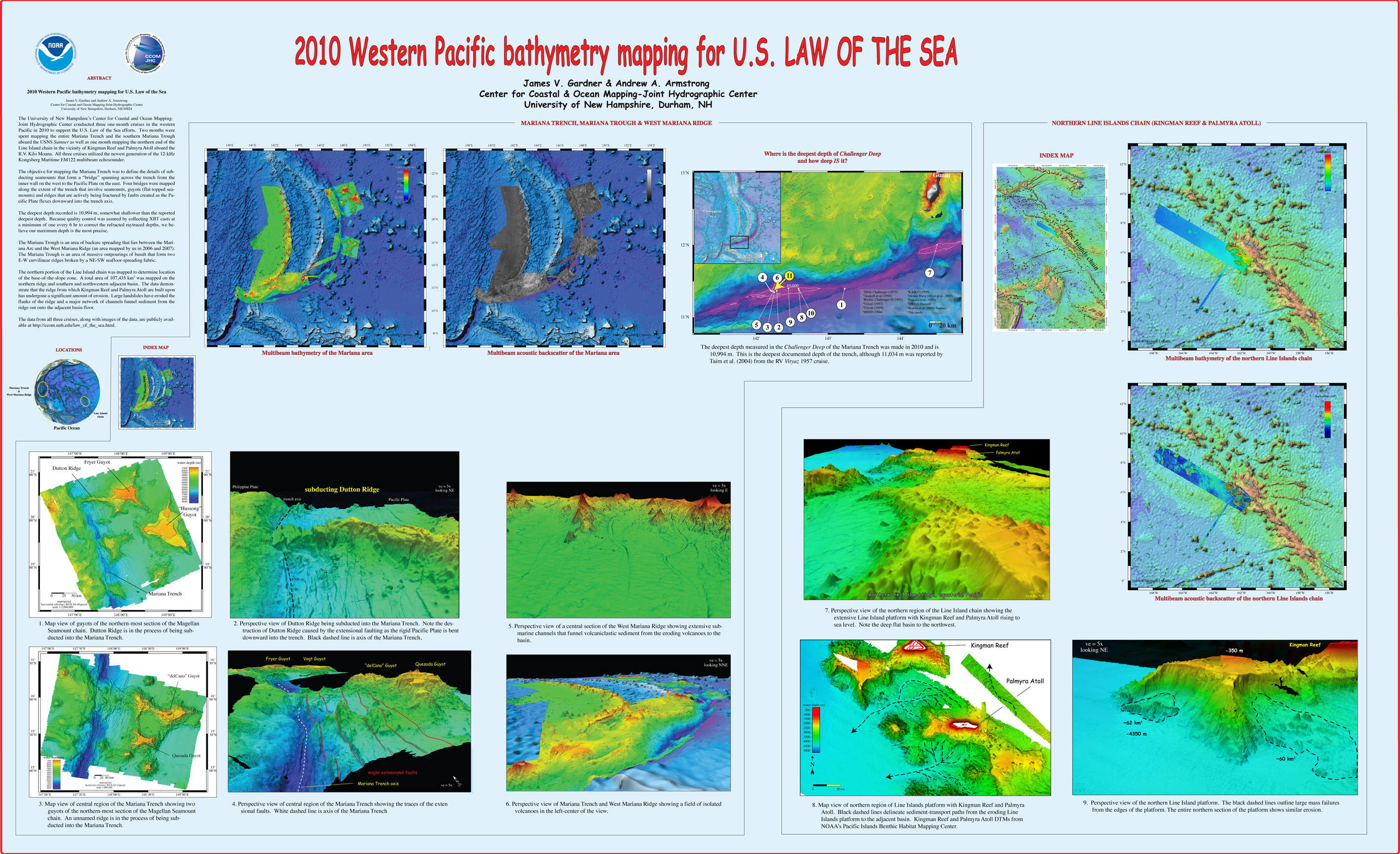
, “2010 Western Pacific bathymetry mapping for U.S. Law of the Sea”, U.S. Hydrographic Conference (US HYDRO). Tampa, FL, USA, 2011. Gardner_2011_USHYDRO_Western_Pacific_bathymetry_for_LOTS.jpg (3.5 MB)
, The Electronic Chart. Fundamentals, Functions and other Essentials: A Textbook for ECDIS Use and Training, Third. Lemmer, The Netherlands: Geomares Publishing, 2011, p. 378.
, “e-Navigation and Pilotage: Challenges and Opportunities”, 2011 Canadian Maritime Pilots Association Congress. Halifax, Nova Scotia, Canada, 2011.
, “Fine-scale sediment distribution at the mouth of the Merrimack River”, Coastal Geotools 2011. Myrtle Beach, SC, USA, 2011.
, “Fine-scale sediment distribution at the mouth of the Merrimack River”, Coastal Geotools 2011. Myrtle Beach, SC, USA, 2011.
, “From Seafloor Mapping to Geological Processes: New Insights in Marine Geomorphic Features Using High-Resolution Acoustic Imaging Techniques”, American Geophysical Union (AGU). San Francisco, CA, USA, 2011.
, “Ground truth operation for seafloor characterization”, Coastal Geotools 2011. Myrtle Beach, SC, USA, 2011.
, “IALA’s Vision of e-Navigation”, 2011 Canadian Maritime Pilots Association Congress. Halifax, Nova Scotia, Canada, 2011.
, “The IHO’s Involvement in e-Navigation”, IALA Bulletin, vol. 2011, No. 1. pp. 26-27, 2011.
, “IHO/FIG/ICA Category A Course Program Submission”, Center for Coastal and Ocean Mapping/ Joint Hydrographic Center, Durham, NH, USA, 2011.
, “The Mariana Trench: A New View Based on Multibeam Echosounding”, American Geophysical Union, Fall Meeting. San Francisco, CA, United States, 2011.
, “New Frontiers in Ocean Exploration: The 2011 E/V NAUTILUS Field Season”, 2011 Fall Meeting, American Geological Union (AGU). San Francisco, CA, USA, 2011.
, “Providing Meteorological and Hydrographic Information via AIS Application-Specific Messages: Challenges and Opportunities”, 2011 US Hydrographic Conference. Tampa, FL, USA, 2011.
, “Testing of AIS Application-Specific Messages to Improve US Coast Guard VTS Operations”, e-Navigation Underway Conference. Copenhagen, Denmark, 2011.
, “U.S. Extended Continental Shelf Cruise to Map Sections of the Mariana Trench and the Eastern and Southern Insular Margins of Guam and the Northern Mariana Islands”, Center for Coastal and Ocean Mapping / Joint Hydrographic Center, 2011. Armstrong_2011_cruise_report_SU10-02_Marianas.pdf (6.86 MB)
, “U.S. Law of the Sea Cruise to Map the Foot of the Slope and 2500-m Isobath of the U.S. Arctic Ocean Margin”, Center for Coastal and Ocean Mapping (CCOM)/Joint Hydrographic Center (JHC), 2011. Mayer_2011_cruise_report_HEALY1102.pdf (12.53 MB)
, “Western Pacific bathymetry mapping for U.S. Law of the Sea”, U.S. Hydro 2011. Tampa, FL, USA, 2011.
, “Canadian e-Navigation User Needs Survey: Report on Comprehensive Results”, Canadian Coast Guard, 2010.
, “New Developments in Lidar Shoreline Mapping and Full-Waveform Lidar at NOAA”, European Lidar Mapping Forum (ELMF). The Hague, South Holland, The Netherlands, 2010.
, “Bathymetric Attributed Grids (BAGs): Discovery of Marine Datasets and Geospatial Metadata Visualization”, Canadian Hydrographic Conference (CHC). Quebec City, Quebec, Canada, 2010.
, “An Arctic Ice Shelf During MIS 6 Constrained by New Geophysical and Geological Data”, Quarternary Science Review, vol. 29. Wiley, pp. 3505-3517, 2010.
, “Production and Use of Nautical Charts”, T-Kartor and ERDAS Nordic User Conference. Ahus, Skane, Sweden, 2010.
, “Comparison and Evaluation of Publicly Available Global Bathymetric Grids”, GEBCO. Lima, Peru, Peru, 2010.
, “Petrography and U-pb, Detrital Zircon Geochronology of Metasedimentary Strata Dredged from the Chukchi Borderland, Amerasia Basin, Arctic Ocean”, American Geophysical Union (AGU). San Francisco, CA, USA, 2010.
, “Sea Ice Coverage as an IHO S-57 Marine Information Overlay (MIO)”, CARIS. Miami, FL, USA, 2010.
, “Progress in Coastal Processes Research in Ghana”, Ocean Sciences Meeting. Portland, OR, USA, pp. 1-1, 2010.
, “Sediment Characteristics of Submarine Landslides on the Upper East Australian Continental Margin--Preliminary findings”, American Geophysical Union (AGU). San Francisco, CA, USA, pp. 1-1, 2010.
, “GEBCO Cookbook, Errors and Uncertainty in the Gridded Bathymetry”, GEBCO. Durham, NH, USA, 2010.
, “Establishing an IALA AIS Binary Message Register: Recommended Process”, International Association of Aids to Navigation and Lighthouse Authorities (IALA-AISM). Cape Town, Western Cape, South Africa, pp. 108-115, 2010.
, “Maritime Information Systems as a Component of e-Navigation .”, The Radio Technical Commission for Maritime Services (RTCM). San Diego, CA, USA, 2010.
, “New Standards for Providing Meteorological and Hydrographic Information via AIS Application-specific Messages”, International Hydrographic Review. Geomatics Information & Trading Center - GITC, Lemmers, Amsterdam, The Netherlands, pp. 37-44, 2010.
, “Maritime Information Systems as a Component of e-Navigation”, International Association of Aids to Navigation and Lighthouse Authorities (IALA-AISM). Cape Town, Western Cape, South Africa, 2010.
, “Progress in Coastal Processes Research in Ghana”, Ocean Sciences Meeting. Portland, OR, USA, pp. 1-1, 2010.
, “Physical Properties and Age of Mid-slope Sediments Dredged from the Eastern Australian Continental Margin--Implication for Continental Margin Erosional Processes”, American Geophysical Union (AGU). San Francisco, CA, USA, pp. 1-1, 2010.
, “GEBCO Cookbook, Errors and Uncertainty in the Gridded Bathymetry”, GEBCO. Durham, NH, USA, 2010.
, “Results from Canadian User Needs Survey”, Canadian Coast Guard and Ministry of Transport, 2010.
, The Electronic Chart: Functions, Potential and Limitations of a New Navigation System, 3rd ed., no. Adam Kerr. Lemmers, Amsterdam, The Netherlands: GeoMares Publishing, 2010, pp. 1-441.
, “ECDIS and Its Role in e-Navigation: The Promise and Reality”, eNavigation Conference. Seattle, WA, USA, 2010.
, “Hydrographic Products/Services as a Fundamental Component of the e-Navigation Concept of Operation”, Canadian Hydrographic Conference (CHC). Quebec City, Quebec, Canada, 2010.
, “Establishing a Regional AIS Application Specific Message Register”, International Association of Aids to Navigation and Lighthouse Authorities (IALA-AISM). Cape Town, Western Cape, South Africa, 2010.
, “Progress in Coastal Processes Research in Ghana”, Ocean Sciences Meeting. Portland, OR, USA, pp. 1-1, 2010.
, “New Frontiers in Ocean Exploration: The 2010 E/V Nautilus Field Season”, American Geophysical Union (AGU). San Francisco, CA, USA, 2010.
, “Progress in Coastal Processes Research in Ghana”, Ocean Sciences Meeting. Portland, OR, USA, pp. 1-1, 2010.
, “Hydrographic Survey Bottom Sampling Specifications: A Remote Sensing Perspective”, Canadian Hydrographic Conference (CHC). Quebec City, Quebec, Canada, 2010.
, “Multibeam mapping of the United States continental margin: Supporting the effort to delinieate the extended continental shelf under Article 76 of the United Nations Convention on the Law of the Sea”, International Hydrographic Conference. Cape Town, South Africa, 2010.
, “Seafloor Mapping In The Arctic:Support For a Potential US Extended Continental Shelf”, International Hydrographic Review, vol. 3. Geomatics Information & Trading Center - GITC, Lemmers, Amsterdam, The Netherlands, pp. 14-23, 2010. Mayer_2010_IHR_Sea_Floor_Mapping_In_The_Arctic.pdf (684.1 KB)
, “Right Whale AIS Project (RAP): Acoustic Detections in the Boston Approaches”, Inland Navigation Technology. Vicksburg, MS, USA, 2009.
, “Current Research on Airborne LIDAR Bathymetry (ALB) Shoreline Mapping”, FUDOTERAM Workshop Reminder on LiDAR Bathymetric Studies. Montreal, Quebec, Canada, 2009.
, “Port ECDIS. Evaluation Report for EFFORTS Project Work Package 1.3”, ISSUS/Hamberg Port Authority, EC Contract No FP6-031486, 2009.
, “Effects of a Large Fishing Closure on Benthic Communitites in the Western Gulf of Maine: Recovery from the Effects of Gillnets and Otter Trawls”, Fisheries Bulletin, vol. 107. National Marine Fisheries Service Scientific Publications Office, pp. 308-317, 2009.
, “USCG Development, Test and Evaluation of AIS Binary Messages for Enhanced VTS Operations”, Institute of Navigation. Anaheim, CA, USA, 2009.
, “Concept: IALA AIS Binary Messages Web Site for Message Catalog and Register”, International Association of Aids to Navigation and Lighthouse Authorities (IALA-AISM). Key West, FL, USA, 2009.
, “Marine Spatial Data Infrastructure (MSDI) Challenges and Opportunities: The Cuban Experience”, GEOMATICA. Havana, Havana, Cuba, 2009.
, “Creating GeoTIFF Photomosaics from Seafloor Video”, Coastal Geotools. Myrtle Beach, SC, USA, 2009.
, The Electronic Chart: Functions, Potential and Limitations of a New Navigation System, 3rd ed., no. Adam Kerr. Lemmers, Amsterdam, The Netherlands: GeoMares Publishing, 2009, pp. 1-322.
, “Inland Navigation Technology '09 - Digital Technology Impact on Safety and Efficiency”, U.S. Army Engineer Research and Development Center, Coastal and Hydrologic Laboratory, 2009.
, “e-Navigation: Concept and Reality”, Sea Technology, vol. 50. Compass Publications Inc., Deer Isle, ME, USA, pp. 7-7, 2009.
, “Development of Port ENC Standard”, Smart Rivers '21. Vienna, Vienna, Austria, 2009.
, “Optimally Displaying 2D Vector Fields of Meteorology and Oceanography”, American Meteorlogical Society. Phoenix, AZ, USA, 2009.
, “e-Navigation and Electronic Charting: Implications for Hydrographic Community”, U.S. Hydrographic Conference (US HYDRO). Norfolk, VA, USA, 2009.
, “e-Navigation: Challenges and Opportunities.”, Inland Navigation Technology. Vicksburg, MS, USA, 2009.
, “Okeanos Explorer - Aligning Today's Technology to a New Paradigm of Ocean Exploration”, FEMME - Kongsberg (users conference). Lisbon, Lisbon, Portugal, 2009.
, “Precise Naviation and Maneuverin in Ports, Evaluation Report for EFFORTS Project Work Package 1.2”, ISSUS/Hamberg Port Authority, EC Contract No FP6-031486, 2009.
, “The New IHO Hydrographic Geospatial Standard for Marine Data and Information”, International Hydrographic Review, vol. 5. Geomatics Information & Trading Center - GITC, Lemmers, Amsterdam, The Netherlands, pp. 44-55, 2009.
, “Advanced Mid-Water Tools for 4D Marine Data Fusion and Visualization”, IEEE Oceans. Biloxi, MS, USA, 2009.
, “e-Navigation: Challenges and Opportunities”, U.S. Hydrographic Conference (US HYDRO). Norfolk, VA, USA, 2009.
, “Advances in the study of marine mammal predator-prey interactions: a novel real-time visualization of independently collected echosounder data using GeoZui4D”, Society for Marine Mammalogy. Quebec City, Quebec, Canada, 2009. Arsenault_2009_SMM_Advances_in_the_study_of_marine_mammal_predator-prey_interactions_a_novel_real-time_visualization_of_independently_collected_echosounder_data_using_GeoZui4D.jpg (3.59 MB)
, “GeoCoastPilot: A Better Way of Organizing and Displaying Information in Support of Port Familiarization”, IEEE Oceans. Biloxi, MS, USA, 2009. Plumlee_09_Oceans_GeoCoastPilot_a_better_way_of_organizing_info_support_port_familiarization.pdf (1.75 MB)
, “Mapping in the Arctic Ocean in Support of a Potential Extended Continental Shelf”, U.S. Hydrographic Conference (US HYDRO). Norfolk, VA, USA, pp. 0-13, 2009. Mayer_09_USHYDRO_Mapping_in_Arctic_in_support_of_potential_ecs.pdf (1.06 MB)
, “U.S. Law of the Sea cruise to map the foot of the slope and 2500-m isobath of the US Arctic Ocean margin, cruise report for 2009”, Center for Coastal and Ocean Mapping (CCOM)/Joint Hydrographic Center (JHC), 2009. Mayer_2009_cruise_report_HE0905.pdf (11.14 MB)
“Visualizing the Operations of the Phoenix Mars Lander”, American Geophysical Union (AGU). San Francisco, CA, USA, 2008.
, “e-Navigation, ECDIS and MIOs: At Present and in the Future”, eNavigation Conference. Seattle, WA, USA, 2008.
, “An Improved Bathymetric Portrayal of the Arctic Ocean: Implications for Ocean Modeling and Geological, Geophysical and Oceanographic Analyses”, Geophysical Research Letters, vol. 35. American Geophysical Union , Washington DC, Washington DC, USA, pp. 0-1, 2008.
, “The Use of Portable Piloting Units”, Digital Ship, vol. 8. Digital Ship Ltd., London, London, UK, pp. 54-55, 2008.
, “e-Navigation, ECDIS and PPUs: Challenges and Opportunities”, IMPA Congress. Bangkok, Bangkok, Thailand, 2008.
, “Marine Electronic Chart Highway Project: The MIO Component”, CARIS. Bath, Bath, UK, 2008.
, “Airborne Lidar Bathymetry Products for Shoreline Mapping”, Joint Airborne LIDAR Bathymetry Technical Center of Expertise Coastal Mapping and Charting Workshop (JALBTCX). San Francisco, CA, USA, 2008.
, “Use of Portable Piloting by Maritime Pilots”, Canadian Hydrographic Conference (CHC). Victoria, British Columbia, Canada, pp. 1-9, 2008.
, “Use of Portable Piloting Units (PPUs) by Maritime Pilots: Study Findings and Implications”, American Pilot's Association Biennial Convention. Kauai, HI, USA, 2008.
, “Development and Assessment of Airborne LIDAR Bathymetry Products for Shoreline Mapping”, Shallow Water Survey Conference (SWS). Durham, NH, USA, 2008.
, “Portable Piloting Units (PPUs): Current Use, Future Trends”, The Radio Technical Commission for Maritime Services (RTCM). San Diego, CA, USA, 2008.
, “MIOs: The What, Why, and How: Seaways”, ACM Computing Surveys. Association for Computing Machinery (ACM), New York, NY, USA, pp. 13-15, 2008.
, “From the Arctic to the Tropics: The U.S. UNCLOS Bathymetric Mapping Program”, Canadian Hydrographic Conference (CHC). Victoria, British Columbia, Canada, pp. 1-11, 2008. Gardner_08_CHC_From_the_Arctice_to_the_Tropics.pdf (1.2 MB)
, “From the Arctic to the tropics: The U.S. UNCLOS bathymetryic mapping program.”, Canadian Hydrographic Conference (CHC). 2008.
, “IHO S-100: The New Hydrographic Geospatial Standard for Marine Data and Information”, Canadian Hydrographic Conference (CHC). Victoria, British Columbia, Canada, pp. 1-18, 2008. Alexander_2008_CHC_IHO_S-100.pdf (1.29 MB)
, “Production of Marine Information Overlays (MIOs) for Marine Environmental Protectoin”, Global Ecology and Oceanography of Harmful Algal Blooms. Sitka, AK, USA, pp. 1-18, 2008. Alexander_2008_GEOHAB_MIOs.ppt (4.04 MB)
, “Recent Mapping and Sampling on the Chukchi Borderland and Alpha/Medeleev Ridge”, American Geophysical Union (AGU), vol. 89. San Francisco, CA, USA, 2008.
, “Recent Mapping and Sampling on the Chukchi Borderland and Alpha/Medeleev Ridge”, American Geophysical Union. San Francisco, CA, United States, 2008.
, “U.S. Law of the Sea Cruise to Map the Foot of the Slope and 2500-m Isobath of the U.S. Arctic Ocean Margin. Cruise Report for 2008”, University of New Hampshire (UNH), Center for Coastal and Ocean Mapping (CCOM)/Joint Hydrographic Center (JHC), 2008. Mayer_08_HEALY_0805_CRUISERPT.pdf (31.06 MB)
, “US UNCLOS Multibeam Data: The Processing of Multibeam Bathymetry and Backcatter”, Hydro International, vol. 8. Geomatics Information & Trading Center - GITC, Lemmers, Amsterdam, The Netherlands, pp. 14-17, 2008. Fonseca_al_2008_hydro_intl.pdf (1.42 MB)
, “Use of Portable Piloting Units by Maritime Pilots”, Canadian Maritime Pilots Association. Vancouver, British Columbia, Canada, pp. 1-9, 2008. Alexander_2008_CHC_Use_Of_Piloting_Units_By_Pilots.pdf (226.06 KB)
, “Status Report on International Inland ENC Developmnet and Standardization”, The Radio Technical Commission for Maritime Services (RTCM). St. Petersburg Beach, FL, USA, 2007.
, “Relationship of Marine Information Overlays (MIOs) to Current/Future IHO Standards”, International Hydrographic Review, vol. 8. Geomatics Information & Trading Center - GITC, Lemmers, Amsterdam, The Netherlands, pp. 80-82, 2007.
, “Specification Format for AIS Binary Messages for Providing Hydrographic-related Information”, U.S. Hydrographic Conference (US HYDRO). Norfolk, VA, USA, pp. 0-21, 2007.
, “First Recovery of Submarine Basalts from the Chukchi Borderland and Alpha/Mendeleev Ridge, Arctic Ocean”, American Geophysical Union (AGU), vol. 89. San Francisco, CA, USA, pp. 2123-2124, 2007.
, “the WEND Concept for Worldwide ENC Database - Past or Future: A Review of Progress and a Look to the Future”, International Hydrographic Review, vol. 8. Geomatics Information & Trading Center - GITC, Lemmers, Amsterdam, The Netherlands, pp. 73-79, 2007.
, “Whale tracking underwater: high frequency acoustic pingers and the instrumented tag (DTAG)”, Acoustical Society of America (ASA). New Orleans, LA, USA, pp. 0-0, 2007.
, “Encoding AIS Binary Messages in XML Format for Providing Hydrographic-related Information”, International Hydrographic Review, vol. 8. Geomatics Information & Trading Center - GITC, Lemmers, Amsterdam, The Netherlands, pp. 36-57, 2007.
, “Tide Aware ENC: Demonstration of an Operational Concept”, U.S. Hydrographic Conference (US HYDRO). Norfolk, VA, USA, pp. 0-0, 2007.
, “European North American-Russian Federation Inland ENC Harmonization Group”, U.S. Hydrographic Conference (US HYDRO). Norfolk, VA, USA, 2007.
, “'Megaclicks': Acoustic Click Trains and Buzzes Produced During Night-time Foraging of Humpback Whales (Megaptera Novaeangliae)”, Biology Letters, vol. 3. Royal Society Publishing, pp. 467-470, 2007.
, “Electronic Navigational Charts and Marine Information Objects for Navigation Safety and Marine Environmental Protection”, Commission on Hydrography Conference (CHC). Veracruz, Veracruz, Mexico, 2007.
, “Development of IHO S-100: The New IHO Geospatial Standard for Hydrographic Data”, International Hydrographic Review, vol. 8. Geomatics Information & Trading Center - GITC, Lemmers, Amsterdam, The Netherlands, pp. 56-62, 2007.
, “Multibeam Bathymetry Mapping for U.S. UNCLOS Concerns: A Gold Mine for Marine Geology”, American Geophysical Union (AGU). San Francisco, CA, USA, 2007.
, “Proposed AIS Binary Message Format Using XML for Providing Hydrographic-related Information”, U.S. Hydrographic Conference (US HYDRO). Norfolk, VA, USA, 2007.
, “'Megaclicks': Acoustic Click Trains and Buzzes Produced During Night-time Foraging of Humpback Whales (Megaptera Novaeangliae)”, Biology Letters, vol. 3. Royal Society Publishing, pp. 467-470, 2007.
, “AIS Binary Message Format Using XML to Provide Hydrographic-related Information”, U.S. Hydrographic Conference (US HYDRO). The Hydrographic Society of America, Norfolk, VA, 2007. Schwehr_07_USHYDRO_AIS_binary_format_using_xml_for_hydrographic_info.jpg (481.49 KB)
, “High Resolution Mapping in support of UNCLOS Article 76: Seeing the seafloor with new eyes”, U.S. Hydrographic Conference (US HYDRO). Norfolk, VA, USA, pp. 12-13, 2007.
, “High-resolution mapping in support of UNCLOS Article 76: Seeing the seafloor with new eyes”, U.S. Hydro Conference. Norfolk, VA, 2007.
, “U.S. Law of the Sea Cruise to Map the Foot of the Slope and 2500-m Isobath of the U.S. Arctic Ocean Margin. Cruise Report for 2007”, University of New Hampshire (UNH), Center for Coastal and Ocean Mapping (CCOM)/Joint Hydrographic Center (JHC), 2007. Mayer_07_cruise_report_HE-0703.pdf (29.54 MB)
, The Electronic Chart. Functions, Potential and Limitations of a New Navigation System. Lemmers, Amsterdam, The Netherlands: Geomatics Information & Trading Center - GITC, 2006, p. 293.
, “Electronic Charts: A Real-time GIS for Vessel Navigation”, GIS Professional. PV Publications Ltd, pp. 20-22, 2006.
, “Proposed Test Bed Project on Production of Large-scale ENCs in the MACHC Region”, University of New Hampshire (UNH), Center for Coastal and Ocean Mapping (CCOM)/Joint Hydrographic Center (JHC), 2006.
, “Effects of the Western Gulf of Maine Closure Area on Bottom Habitats: A Preliminary GIS-based Assessment”, GIS Conference. Cambridge, MA, USA, 2006.
, “Comparative Evaluation of Official Electronic Chart Data in U.S. Waters”, Canadian Hydrographic Conference (CHC). Halifax, Nova Scotia, Canada, 2006.
, “A Process for Producing Ice Coverage Marine Information Objects (MIOs) in IHO S-57 Format”, International Hydrographic Review, vol. 7. Geomatics Information & Trading Center - GITC, Lemmers, Amsterdam, The Netherlands, pp. 55-63, 2006.
, “Recommendation for Involving the Private Sector in Producing Small-scale ENCs from INT Charts”, University of New Hampshire (UNH), Center for Coastal and Ocean Mapping (CCOM)/Joint Hydrographic Center (JHC), 2006.
, “New Multibeam Mapping of the Gulf of Maine”, GIS Conference. Cambridge, MA, USA, 2006.
, “A Process for Producing Ice Coverage Marine Information Objects (MIOs) in IHO S-57 Format”, International Hydrographic Review, vol. 7. Geomatics Information & Trading Center - GITC, Lemmers, Amsterdam, The Netherlands, pp. 55-63, 2006.
, “Mapping Supports Potential Submission to U.N. Law of the Sea”, EOS Transactions, American Geophysical Union, vol. 87. American Geophysical Union , Washington DC, Washington DC, USA, pp. 157-159, 2006. Gardner_06_Eos_Mapping_supports_potential_submission_to_un_lots.pdf (270.7 KB)
, “Visualizing the Underwater Behavior of Humpback Whales”, IEEE Computer Graphics and Application, vol. 26. IEEE, Washington DC, Washington DC, USA, pp. 14-18, 2006. Ware_08_CGA_Visualizing_underwater_behavior_of_humpback_whales.pdf (1.79 MB)
, “Coral Reef Electronic Chart Initiative, Protecting Corals, Saving Ships”, U.S. Hydrographic Conference (US HYDRO). San Diego, CA, USA, pp. 0-0, 2005.
, “Underwater behavior of humpback whales in a western North Atlantic foraging area”, Biennial Conference on the Biology of Marine Mammals (CBMM). San Diego, CA, USA, 2005.
, “A Novel Sound Recorded in Association with Bottom Feeding in Humpback Whales”, Biennial Conference on the Biology of Marine Mammals (CBMM). San Diego, CA, USA, pp. 0-0, 2005.
, “Inland ENC Encoding Guide”, University of New Hampshire (UNH), Center for Coastal and Ocean Mapping (CCOM)/Joint Hydrographic Center (JHC), 2005.
, “Multi-dimensional, multi-national, multi-faceted hydrographic training: the Nippon Foundation GEBCO training program at the University of New Hampshire”, U.S. Hydrographic Conference (US HYDRO). San Diego, CA, USA, pp. 0-0, 2005.
, “GeoZui4D: A New Method for Viewing Multisensor Tag-derived Data to Investigate the Underwater Behavior of Marine Mammals”, Biennial Conference on the Biology of Marine Mammals (CBMM). San Diego, CA, USA, pp. 0-18, 2005.
, “GEBCO: A New 1:35000000 Scale Printed Map”, EOS Transactions, American Geophysical Union . San Francisco, CA, USA, pp. 0-0, 2005.
, “North American European Inland ENC Harmonization Group: Building on IHO S-57 for an International Brownwater Standard”, The Radio Technical Commission for Maritime Services (RTCM). St. Andrews, New Brunswick, Canada, pp. 0-0, 2005.
, “A Novel Sound Recorded in Association with Bottom Feeding in Humpback Whales”, Biennial Conference on the Biology of Marine Mammals (CBMM). San Diego, CA, USA, pp. 0-0, 2005.
, “On the use of historical bathymetric data to determine changes in bathymetry”, International Hydrographic Review, vol. 6. Geomatics Information & Trading Center - GITC, Lemmers, Amsterdam, The Netherlands, pp. 25-41, 2005.
, “Multi-dimensional, multi-national, multi-faceted hydrographic training: the Nippon Foundation GEBCO training program at the University of New Hampshire”, U.S. Hydrographic Conference (US HYDRO). San Diego, CA, USA, pp. 0-0, 2005.
, “Multibeam Bathymetric and Sediment Profiler Evidence for Ice Grounding on the Chukchi Borderland, Arctic Ocean”, Quaternary Research, vol. 63. Elsevier, New York, NY, USA, pp. 150-160, 2005.
, “Making Useful and Useable Geovisualization: Design and Evaluation Issues”, in Exploring Geovisualization, no. J. Dykes, A.M. MacEachren & M.J. Kraak, New York, NY, USA: Elsevier, 2005, pp. 541-554.
, “Next Edition of IHO S-57 (Edition 4): Much more than ENCs”, U.S. Hydrographic Conference (US HYDRO). San Diego, CA, USA, pp. 0-0, 2005.
, “Interactively Visualizing Oceanographic Time-varying Oceanographic Data”, Offshore Technology Conference (OTC). Houston, TX, USA, pp. 0-0, 2005.
, “Panoramic Images for Situational Awareness in a 3D Chart-of-the-Future Display”, U.S. Hydrographic Conference (US HYDRO). San Diego, CA, USA, pp. 0-8, 2005.
, “Future Edition of IHO S-57 (4.0)”, International Hydrographic Review, vol. 6. Geomatics Information & Trading Center - GITC, Lemmers, Amsterdam, The Netherlands, pp. 66-72, 2005.
, “Seafloor Sounding in Polar and Remote Regions (SSPARR) Project - Initial Field Trials”, EOS Transactions, American Geophysical Union . San Francisco, CA, USA, pp. 0-0, 2005.
, “A system for real-time spatio-temporal 3-D Data Visualization in Underwater Robotic Exploration”, International Conference on Robotics and Automation (ICRA). Barcelona, Barcelona, Spain, pp. 0-0, 2005.
, “Mapping and Characterizing Oyster Reefs using Acoustic Techniques, Underwater Videography and Quadrat Sampling”, Benthic Habitats and the Effects of Fishing, no. P.W. Barnes & J.P. Thomas. American Fisheries Society, Bethesda, MD, USA, pp. 153-159, 2005.
, “New Views of the Gulf of Alaska Margin Mapped for UNCLOS Applications”, University of New Hampshire (UNH), Center for Coastal and Ocean Mapping (CCOM)/Joint Hydrographic Center (JHC), 2005. Mayer_05_Gulf_of_Alaska_Margin_Mapped_for_UNCLOS_applications.pdf (65.49 KB)
, “New Views of the Gulf of Alaska Margin Mapped for UNCLOS Applications”, University of New Hampshire (UNH), Center for Coastal and Ocean Mapping (CCOM)/Joint Hydrographic Center (JHC), 2005. Mayer_05_Gulf_of_Alaska_Margin_Mapped_for_UNCLOS_applications.pdf (65.49 KB)
, “New Views of the U.S. Atlantic Margin Mapped for UNCLOS Applications”, EOS Transactions, American Geophysical Union , vol. 86. San Francisco, CA, USA, pp. 0-2, 2005. Gardner_05_AGU_US_Atlantic_Margin_Mapped_for_UNCLOS_applications.pdf (72.17 KB)
, “New Views of the U.S. Continental Margins”, U.S. Hydrographic Conference (US HYDRO). San Diego, CA, USA, pp. 29-31, 2005. Gardner_05_USHydro_New_views_of_US_continental_margins.pdf (579.95 KB)
, “Seafloor Sounding in Polar and Remote Regions - A New Instrument for Unattended Bathymetric Observations”, Spring Meeting - Joint Assembly EOS Transactions, American Geophysical Union. New Orleans, LA, USA, pp. 0-2, 2005. Anderson_2005_AGU_Seafloor_Sounding_Polar_Remote_Regions_New_Instrument.pdf (85.89 KB)
, “U.S. Law of the Sea Mapping”, Hydro International, vol. 9. Geomatics Information & Trading Center - GITC, Lemmers, Amsterdam, The Netherlands, pp. 42-45, 2005. Gardner_05_Hydro_US_Law_of_the_Sea_Mapping.pdf (16.23 MB)
, “Inland ECDIS Development and Standardization”, International Hydrographic Office (IHO), CHRIS, 2004.
, “Frames of Reference in Virtual Object Rotation”, ACM SIGGRAPH Symposium on Applied Perception in Graphics and Visualization (APGV). San Diego, CA, USA, 2004.
, “Inland ECS: More than just ECDIS in Montreal Canada”, The Radio Technical Commission for Maritime Services (RTCM). St. Andrews, New Brunswick, Canada, pp. 0-0, 2004.
, “Ice-dammed Lakes and Rerouting of the Drainage of Northern Eurasia during the Last Glaciation”, Journal of Quaternary Science, vol. 23. Wiley InterScience, pp. 1313-1332, 2004.
, “Open ECDIS Forum (OEF) Activities”, International Hydrographic Office (IHO), CHRIS, 2004.
, “Evaluating U.S. data holdings relevant to the definition of continental shelf limits”, in Legal and Scientific Aspects of Continental Shelf Limits, 8th ed., no. M.H Nordquist, J.N. Moore & T. Heider, Leiden, South Holland, The Netherlands: Martinus Nijhoff legacy_publishers, 2004, pp. 313-330.
, “Multibeam Error Management: New Data Processing Trends in Hydrography”, Hydro International, vol. 8. Geomatics Information & Trading Center - GITC, Lemmers, Amsterdam, The Netherlands, pp. 6-9, 2004.
, “The Next Edition of IHO-S-57 (4.0)”, International Hydrographic Bureau, 2004.
, “Automatic Radar Positioning as a Backup to DGPS”, The Radio Technical Commission for Maritime Services (RTCM). St. Andrews, New Brunswick, Canada, pp. 0-0, 2004.
, “Integrated Navigation System: Not a Sum of Its Parts”, Canadian Hydrographic Conference (CHC). St. Andrews, New Brunswick, Canada, pp. 0-0, 2004.
, “Investigations for Ergonomic Design of AIS Symbols for ECDIS”, U.S. Army, U.S. Army Corps of Engineers / Topographic Engineering Center (TEC), 2004.
, “Investigations for Ergonomic Presentation of AIS Symbols for ECDIS”, International Hydrographic Review, vol. 5. Geomatics Information & Trading Center - GITC, Lemmers, Amsterdam, The Netherlands, pp. 26-36, 2004.
, “Activities of IHO-IEC Harmonization Group on Marine Information Objects (HGMIO)”, International Hydrographic Office (IHO), CHRIS, 2004.
, “Revival of ECDIS?”, Hydro International, vol. 8. Geomatics Information & Trading Center - GITC, Lemmers, Amsterdam, The Netherlands, pp. 34-35, 2004.
, “Tectonic Details of the Tjornes Fracture Zone, an Onshore-Offshore Ridge-transform in N-Iceland”, EOS Transactions, American Geophysical Union . San Francisco, CA, USA, pp. 0-0, 2004.
, “The CCOM Chart of the Future Project: Maximizing Mariner Effectiveness Through Fusion of Marine & Visualization Technologies”, Marine Transportation System Research and Technology Coordination Conference. St. Andrews, New Brunswick, Canada, pp. 0-0, 2004.
, “Hydrographic Interoperability Report”, Marine Magnetics, 2004.
, “Ice-dammed Lakes and Rerouting of the Drainage of Northern Eurasia during the Last Glaciation”, Journal of Quaternary Science, vol. 23. Wiley InterScience, pp. 1313-1332, 2004.
, “The Importance of Stereo, Eye Coupled Perspective and Touch for Eye Hand Coordination”, Presence: Teleoperators and Virtual Environments, vol. 13. MIT Press, Cambridge, MA, USA, pp. 549-559, 2004. Arsenault_2004_Presence_Importance_Stereo_Eye_Coupled_Perspective.pdf (362.69 KB)
, “A System for Visualizing Time-varying Oceanographic 3D Data”, IEEE Oceans. Kobe, Kobe, Japan, pp. 0-5, 2004. Arsenault_2004_Oceans_System_for_Visualizing_Time_Varying_Ocean_Data.pdf (942.8 KB)
, “Electronic Chart of the Future: The Hampton Roads Project”, U.S. Hydrographic Conference (US HYDRO). Biloxi, MS, USA, pp. 0-8, 2003.
, “Converting High-Density Bathymetry into the 'Next Generation' ENC”, Shallow Water Survey Conference (SWS). St. Andrews, New Brunswick, Canada, pp. 0-0, 2003.
, “A Synopsis of Electronic Charting Standards and Organizations, with Recommendations for U.S. Army Corps of Engineers Involvement”, U.S. Army, U.S. Army Corps of Engineers / Topographic Engineering Center (TEC), 2003.
, “The Importance of Physical and Biogenic Structure to Juvenile Fishes on the Shallow Inner Continental Shelf”, Estuaries, vol. 26. The Estuarine Research Federation, pp. 12-20, 2003.
, “Preliminary Studies of the Impact of Sea Level Rise on Coastal Environments (New Hampshire, USA)”, International Conference on Coastal Sediments (ICCS). Clearwater Beach, FL, USA, pp. 0-13, 2003.
, “New Paradigms for Hydrographic Data Processing and Products”, International Conference on High-Resolution Survey in Shallow Water (HRSSW). St. Andrews, New Brunswick, Canada, pp. 0-0, 2003.
, “Electronic Chart of the Future: The Hampton Roads Project”, U.S. Hydrographic Conference (US HYDRO). Biloxi, MS, USA, pp. 0-8, 2003.
, “A World Class ECDIS Laboratory”, Hydro International, vol. 7. Geomatics Information & Trading Center - GITC, Lemmers, Amsterdam, The Netherlands, pp. 7-9, 2003.
, “The Rise and Stall of ECDIS: Where are We heading?”, International ECDIS Conference. Singapore, Singapore, Singapore, pp. 0-0, 2003.
, “Analysis of Data Relevant to Extending a Coastal State's Continental Margin Under Law of the Sea Article 76”, International Hydrographic Review, vol. 4. Geomatics Information & Trading Center - GITC, Lemmers, Amsterdam, The Netherlands, pp. 2-18, 2003.
, “Joint USM-NAVOCEANO ECDIS Laboratory”, International ECDIS Conference. Singapore, Singapore, Singapore, pp. 0-0, 2003.
, “New Paradigms for Hydrographic Data Processing and Products”, International Conference on High-Resolution Survey in Shallow Water (HRSSW). St. Andrews, New Brunswick, Canada, pp. 0-0, 2003.
, “Electronic Chart of the Future: The Hampton Roads Project”, U.S. Hydrographic Conference (US HYDRO). Biloxi, MS, USA, pp. 0-8, 2003.
, “Harmonization of European and North American Inland ECDIS Standards”, International ECDIS Conference. Singapore, Singapore, Singapore, pp. 0-0, 2003.
, Mapping and Characterizing Subtidal Oyster Reefs Using Acoustic Techniques, Underwater Videography and Quadrat Counts, no. P.W. Barnes & J.P. Thomas. Bethesda, MD, USA: American Fisheries Society, 2003.
, “The Importance of Stereo, Eye Coupled Perspective and Touch for Eye-Hand Coordination”, Presence: Teleoperators and Virtual Environments. MIT Press, Cambridge, MA, USA, pp. 0-0, 2003.
, “Measuring Ambient Ocean Bubble Fields Uusing a Multibeam Sonar”, Acoustical Society of America (ASA). Austin, TX, USA, pp. 0-0, 2003.
, “New Paradigms for Hydrographic Data Processing and Products”, International Conference on High-Resolution Survey in Shallow Water (HRSSW). St. Andrews, New Brunswick, Canada, pp. 0-0, 2003.
, “Electronic Charts (Chapter 14)”, in The American Practical Navigator, Bethesda, MD, USA: National Imaging and Mapping Agency, 2003, pp. 199-215. Alexander_2003_APN_Electronic_charts.pdf (278.37 KB)
, “Fusing Information in a 3D Chart of the Future Display”, U.S. Hydrographic Conference (US HYDRO). Biloxi, MS, USA, pp. 0-7, 2003. Arsenault_2003_Hydro_Fusing_Info_3D_Chart_of_the_Future.pdf (526.83 KB)
, “Fusing Information in a 3D Chart-of-the-Future Display”, U.S. Hydrographic Conference (US HYDRO). The Hydrographic Society of America, Biloxi, MS, 2003. Arsenault_2003_Vislab_Fusing_info_in_3D_Chart-of-the-future_display.jpg (874.53 KB)
, “Haptic-GeoZui3D: Exploring the Use of Haptics in AUV Path Planning”, Unmanned Untethered Submersible Technology Symposium (UUST). Autonomous Undersea Systems Institute , Durham, NH, 2003. Komerska_2003_UUST_Haptic-GeoZui3D-AUV_path_planning.jpg (722.73 KB)
, “Marine Information Objects (MIO) and ECDIS: Concept and Practice”, Underwater Acoustic Measurements: Technologies & Results (UAM). Heraklion, Crete, Greece, pp. 0-5, 2003. Alexander_2003_Hydro_MIOs_and_ECDIS_Concept_Practice.pdf (22.15 KB)
, “We Visited for You - 2nd International ECDIS Conference”, Hydro International, vol. 7. Geomatics Information & Trading Center - GITC, Lemmers, Amsterdam, The Netherlands, pp. 1-38, 2003.
, “Back-up Arrangements for ECDIS: Different Options and Perspectives”, Canadian Hydrographic Conference (CHC). Toronto, Ontario, Canada, pp. 0-0, 2002.
, “Distribution Options Based on WEND”, Gulf of Mexico Hydrographic Commission, Electronic Chart Working Group, 2002.


