Publications
, “U.S. Law of the Sea cruises to map sections of the Mariana Trench and the eastern and southern insular margins of Guam and the Northern Mariana Islands”, University of New Hampshire (UNH), Center for Coastal and Ocean Mapping (CCOM)/Joint Hydrographic Center (JHC), 2010. Gardner_2010_cruise_report_SU10-1_Marianas.pdf (4.88 MB)
, “U.S. Law of the Sea Cruise to Map the Western Insular Margin and 2500-m Isobath of Guam and the Northern Mariana Islands. Cruise Report”, University of New Hampshire (UNH), Center for Coastal and Ocean Mapping (CCOM)/Joint Hydrographic Center (JHC), 2007. Gardner_07_cruise_report_BD07-1.pdf (2.54 MB)
, “U.S. Law of the Sea Cruise to Map the Western Flank of the Kingman Reef-Palmyra Atoll Section of the Line Islands, Equatorial Pacific Ocean”, Center for Coastal and Ocean Mapping / Joint Hydrographic Center, Durham, NH, 2015. Cruise-Report-KM1520-Kingman-Palmyra.pdf (10.78 MB)
, “U.S. Law of the Sea Cruise to Map the Southern Flank of the Kingman Reef-Palmyra Atoll section of the Line Islands, Equatorial Pacific Ocean”, Center for Coastal and Ocean Mapping / Joint Hydrographic Center, Durham, NH, 2010. Gardner_2010_cruise_report_KM1009_Kingman-Palmyra.pdf (4.12 MB)
, “U.S. Law of the Sea Cruise to Map the Foot of the Slope of the Northeast U.S. Atlantic Continental Margin: Leg 6”, University of New Hampshire (UNH), Center for Coastal and Ocean Mapping (CCOM)/Joint Hydrographic Center (JHC), 2008. Calder_08_cruise_report_Atlantic_KNOX17RR.pdf (7.4 MB)
, “U.S. Law of the Sea Cruise to Map the Foot of the Slope of the Northeast U.S. Atlantic Continental Margin: Leg 8”, University of New Hampshire, Center for Coastal and Ocean Mapping (CCOM)/Joint Hydrographic Center (JHC), 2015. cruise-report-MGL15-12-atlantic.pdf (3.72 MB)
, “U.S. Law of the Sea Cruise to Map the Foot of the Slope of the Northeast U.S. Atlantic Continental Margin: Leg 7”, Center for Coastal and Ocean Mapping / Joint Hydrographic Center, Durham, NH, 2012. cruise-report-RB12-1-Atlantic.pdf (2.26 MB)
, “U.S. Law of the Sea cruise to map the foot of the slope and 2500-m isobath of the US Arctic Ocean margin, cruise report for 2009”, Center for Coastal and Ocean Mapping (CCOM)/Joint Hydrographic Center (JHC), 2009. Mayer_2009_cruise_report_HE0905.pdf (11.14 MB)
, “U.S. Law of the Sea Cruise to Map the Foot of the Slope and 2500-m Isobath of the U.S. Arctic Ocean Margin. Cruise Report for 2007”, University of New Hampshire (UNH), Center for Coastal and Ocean Mapping (CCOM)/Joint Hydrographic Center (JHC), 2007. Mayer_07_cruise_report_HE-0703.pdf (29.54 MB)
, “U.S. Law of the Sea Cruise to Map the Foot of the Slope and 2500-m Isobath of the Northeast U.S. Atlantic Continental Margin: Legs 4 and 5. Cruise Report”, University of New Hampshire (UNH), Center for Coastal and Ocean Mapping (CCOM)/Joint Hydrographic Center (JHC), 2005. Cartwright_05_cruise_report_PF05-1.pdf (1.59 MB)
, “U.S. Law of the Sea Cruise to Map the Foot of the Slope and 2500-m Isobath of the U.S. Arctic Ocean Margin. Cruise Report for 2004”, University of New Hampshire (UNH), Center for Coastal and Ocean Mapping (CCOM)/Joint Hydrographic Center (JHC), 2004. Mayer_04_cruise_report_HE-0405.pdf (1.94 MB)
, “U.S. Law of the Sea Cruise to Map the Foot of the Slope and 2500-m Isobath of the U.S. Arctic Ocean Margin, Barrow to Barrow. Cruise Report”, University of New Hampshire (UNH), Center for Coastal and Ocean Mapping (CCOM)/Joint Hydrographic Center (JHC), 2003. Mayer_03_cruise_report_HE-0302.pdf (1.5 MB)
, “U.S. Law of the Sea Cruise to Map the Foot of the Slope and 2500-m Isobath of the U.S. Arctic Ocean Margin. Cruise Report for 2008”, University of New Hampshire (UNH), Center for Coastal and Ocean Mapping (CCOM)/Joint Hydrographic Center (JHC), 2008. Mayer_08_HEALY_0805_CRUISERPT.pdf (31.06 MB)
, “U.S. Law of the Sea Cruise to Map the Foot of the Slope and 2500-m Isobath of the Florida Escarpment and Sigsbee Escarpment, Northern Gulf of Mexico Continental Marg. Cruise Report”, University of New Hampshire (UNH), Center for Coastal and Ocean Mapping (CCOM)/Joint Hydrographic Center (JHC), 2007. Gardner_07_cruise_report_NR07-1.pdf (21.74 MB)
, “U.S. Law of the Sea Cruise to Map the Foot of the Slope and 2500-m Isobath of the Northeast US Atlantic Continental Margin: Legs 1, 2 and 3. Cruise Report”, University of New Hampshire (UNH), Center for Coastal and Ocean Mapping (CCOM)/Joint Hydrographic Center (JHC), 2004. Gardner_04_cruise_report_HEN04-1.pdf (2.24 MB)
, “U.S. Law of the Sea Cruise to Map the Foot of the Slope and 2500-m Isobath of the Gulf of Alaska Continental Margin. Cruise Report”, University of New Hampshire (UNH), Center for Coastal and Ocean Mapping (CCOM)/Joint Hydrographic Center (JHC), 2005. Gardner_05_cruise_report_KM0514.pdf (9.58 MB)
, “U.S. Law of the Sea Cruise to Map the Foot of the Slope and 2500-m Isobath of the U.S. Arctic Ocean Margin”, Center for Coastal and Ocean Mapping (CCOM)/Joint Hydrographic Center (JHC), 2011. Mayer_2011_cruise_report_HEALY1102.pdf (12.53 MB)
, “U.S. Law of the Sea Cruise to Map the Eastern Mendocino Ridge, Eastern Pacific Ocean”, University of New Hampshire, Durham, NH, 2009. Gardner_09_cruise_report_EX0903_Mendocino.pdf (2.19 MB)
, “U.S. Law of the Sea Cruise to Map and Sample the US Arctic Ocean Margin”, University of New Hampshire (UNH), Center for Coastal and Ocean Mapping (CCOM)/Joint Hydrographic Center (JHC), 2012. HEALY1202_FINAL_CRUISE REPORT.pdf (9.31 MB)
, “U.S. Law of the Sea Cruise to Map and Sample the US Arctic Ocean Margin, Healy 1603”, Center for Coastal and Ocean Mapping / Joint Hydrographic Center, University of New Hampshire, Durham, NH, 2016.
, “U.S. Law of the Sea Cruise to Complete the Mapping of Necker Ridge, Central Pacific Ocean”, Center for Coastal and Ocean Mapping (CCOM)/Joint Hydrographic Center (JHC), 2011. Gardner_2011_Cruise_Report_KM1121_NeckerRidge.pdf (2.31 MB)
, “U.S. Extended Continental Shelf Cruise to Map Sections of the Mendocino Ridge”, University of New Hampshire, Durham, NH, 2014. cruise-report 2014-AT26-21-Mendocino-Ridge.pdf (12.87 MB)
, “U.S. Extended Continental Shelf Cruise to Map Sections of the Mariana Trench and the Eastern and Southern Insular Margins of Guam and the Northern Mariana Islands”, Center for Coastal and Ocean Mapping / Joint Hydrographic Center, 2011. Armstrong_2011_cruise_report_SU10-02_Marianas.pdf (6.86 MB)
, “U.S. Extended Continental Shelf Cruise to Map Necker Ridge and Vicinity, Central Pacific Ocean”, 2017. KM17-18-Cruise-Report.pdf (2.07 MB)
, “U.S. Extended Continental Shelf Cruise to Map Gulf of Alaska, Eastern Pacific”, Center for Coastal and Ocean Mapping / Joint Hydrographic Center, Durham, NH, 2018. KM1811-Cruise-Report.pdf (3.46 MB)
, “U.S. Extended Continental Shelf Cruise to Map Gaps in Kela and Karin Ridges, Johnston Atoll, Equatorial Pacific Ocean”, CCOM/JHC, Durham, NH, 2014. lots-cruise-report-km14-17-johnston-atoll.pdf (24.43 MB)
, “Report on the LOTS Cruise to Map Foot of the Slope and 2500-m Isobath of Bowers Ridge and Beringian Margin, Bering Sea. Cruise Report”, University of New Hampshire (UNH), Center for Coastal and Ocean Mapping (CCOM)/Joint Hydrographic Center (JHC), 2003. Gardner_03_cruise_report_DA0301.pdf (8.01 MB)
, “New Views of the Gulf of Alaska Margin Mapped for UNCLOS Applications”, University of New Hampshire (UNH), Center for Coastal and Ocean Mapping (CCOM)/Joint Hydrographic Center (JHC), 2005. Mayer_05_Gulf_of_Alaska_Margin_Mapped_for_UNCLOS_applications.pdf (65.49 KB)
, “Law of the Sea Cruise to Map the Western Insular Margin and 2500-m Isobath of Guam and the Northern Mariana Islands. Cruise Report”, University of New Hampshire (UNH), Center for Coastal and Ocean Mapping (CCOM)/Joint Hydrographic Center (JHC), 2006. Gardner_06_cruise_report_BD06-1.pdf (2.02 MB)
, “Extended Continental Shelf Mapping Cruise in Vicinity of Palmyra Atoll”, Center for Coastal and Ocean Mapping / Joint Hydrographic Center, Durham, NH, 2016. RB1601-line-islands-kingman-palmyra.pdf (7.63 MB)
, “The Compilation and Analysis of Data Relevant to a U.S. Claim Under United Nations Law of the Sea Article 76: A Preliminary Report”, University of New Hampshire (UNH), Center for Coastal and Ocean Mapping (CCOM)/Joint Hydrographic Center (JHC), 2002. Mayer_02_Compilation_analysis_data_relevant_to_UNCLOS_76.pdf (7.88 MB)
, “The Mariana Trench: A New View Based on Multibeam Echosounding”, American Geophysical Union, Fall Meeting. San Francisco, CA, United States, 2011.
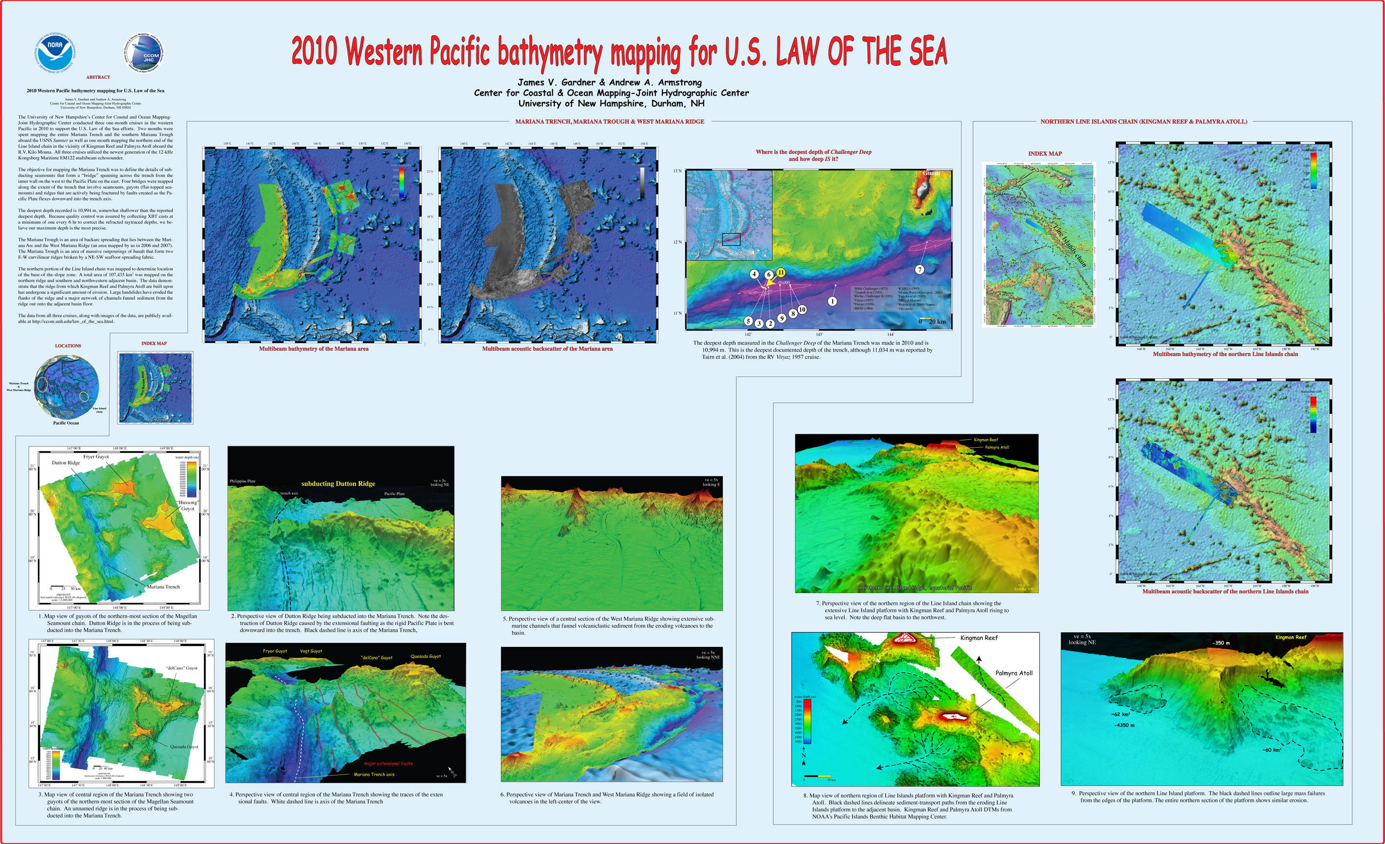
, “2010 Western Pacific bathymetry mapping for U.S. Law of the Sea”, U.S. Hydrographic Conference (US HYDRO). Tampa, FL, USA, 2011. Gardner_2011_USHYDRO_Western_Pacific_bathymetry_for_LOTS.jpg (3.5 MB)
, “The West Mariana Ridge, Western Pacific Ocean: Geomorphology and Processes from New Multibeam Data”, Geological Society of America Bulletin (GSAB), vol. 122. The Geological Society of America (GSA), pp. 1378-1388, 2010. Gardner_2010_GSAB_West_Mariana_Ridge_Geomorphology_and_processes_from_new_multibeam_data.pdf (4.28 MB)
, “US UNCLOS Multibeam Data: The Processing of Multibeam Bathymetry and Backcatter”, Hydro International, vol. 8. Geomatics Information & Trading Center - GITC, Lemmers, Amsterdam, The Netherlands, pp. 14-17, 2008. Fonseca_al_2008_hydro_intl.pdf (1.42 MB)
, “U.S. Law of the Sea Mapping”, Hydro International, vol. 9. Geomatics Information & Trading Center - GITC, Lemmers, Amsterdam, The Netherlands, pp. 42-45, 2005. Gardner_05_Hydro_US_Law_of_the_Sea_Mapping.pdf (16.23 MB)
, “Seafloor Mapping In The Arctic:Support For a Potential US Extended Continental Shelf”, International Hydrographic Review, vol. 3. Geomatics Information & Trading Center - GITC, Lemmers, Amsterdam, The Netherlands, pp. 14-23, 2010. Mayer_2010_IHR_Sea_Floor_Mapping_In_The_Arctic.pdf (684.1 KB)
, “Mapping Supports Potential Submission to U.N. Law of the Sea”, EOS Transactions, American Geophysical Union, vol. 87. American Geophysical Union , Washington DC, Washington DC, USA, pp. 157-159, 2006. Gardner_06_Eos_Mapping_supports_potential_submission_to_un_lots.pdf (270.7 KB)
, “Analysis of Data Relevant to Extending a Coastal State's Continental Margin Under Law of the Sea Article 76”, International Hydrographic Review, vol. 4. Geomatics Information & Trading Center - GITC, Lemmers, Amsterdam, The Netherlands, pp. 2-18, 2003.
, “Application of the General Bathymetric Chart of the Oceans (GEBCO) Digital Atlas in the Delineation of Continental Shelves Under Article 76”, Journal of Ocean Technology, vol. 3. Journal of Ocean Technology (JOT), pp. 24-29, 2008.
, “New Views of the U.S. Continental Margins”, U.S. Hydrographic Conference (US HYDRO). San Diego, CA, USA, pp. 29-31, 2005. Gardner_05_USHydro_New_views_of_US_continental_margins.pdf (579.95 KB)
, “Mapping in the Arctic Ocean in Support of a Potential Extended Continental Shelf”, U.S. Hydrographic Conference (US HYDRO). Norfolk, VA, USA, pp. 0-13, 2009. Mayer_09_USHYDRO_Mapping_in_Arctic_in_support_of_potential_ecs.pdf (1.06 MB)
, “High Resolution Mapping in support of UNCLOS Article 76: Seeing the seafloor with new eyes”, U.S. Hydrographic Conference (US HYDRO). Norfolk, VA, USA, pp. 12-13, 2007.
, “From the Arctic to the tropics: The U.S. UNCLOS bathymetryic mapping program.”, Canadian Hydrographic Conference (CHC). 2008.
, “From the Arctic to the Tropics: The U.S. UNCLOS Bathymetric Mapping Program”, Canadian Hydrographic Conference (CHC). Victoria, British Columbia, Canada, pp. 1-11, 2008. Gardner_08_CHC_From_the_Arctice_to_the_Tropics.pdf (1.2 MB)
, “Western Pacific bathymetry mapping for U.S. Law of the Sea”, U.S. Hydro 2011. Tampa, FL, USA, 2011.
, “From Seafloor Mapping to Geological Processes: New Insights in Marine Geomorphic Features Using High-Resolution Acoustic Imaging Techniques”, American Geophysical Union (AGU). San Francisco, CA, USA, 2011.
, “The impacts of a non-accepted boundary claim: Russia’s frontier in the Arctic Ocean”, Association of American Geographers (AAG). Boston, MA, USA, 2008.
, “Multibeam Bathymetry Mapping for U.S. UNCLOS Concerns: A Gold Mine for Marine Geology”, American Geophysical Union (AGU). San Francisco, CA, USA, 2007.
, “Seafloor Terrain Analysis and Geomorphology of the Greater Los Angeles Margin and San Pedro Basin, Southern California”, in Earth Science in the Urban Ocean: The Southern California Continental Borderland., no. H.J. Lee & W.R. Normark, The Geological Society of America (GSA), 2009, pp. 9-28. Dartnell_2009_GSA_Seafloor_terrain_analysis_and_geomorphology_LA_margin.pdf (4.33 MB)
, “Challenges of Collecting Law of the Sea Data in the Arctic: The Arctic and Law of the Sea”, in International Energy Policy, the Arctic and the Law of the Sea, 9th ed., no. M.H. Nordquist, J.N. Moore & A.S. Skaridov, Leiden, South Holland, The Netherlands: Martinus Nijhoff legacy_publishers, 2005, pp. 125-140.


