Publications
, “U.S. Law of the Sea Cruise to Map and Sample the US Arctic Ocean Margin”, University of New Hampshire (UNH), Center for Coastal and Ocean Mapping (CCOM)/Joint Hydrographic Center (JHC), 2012. HEALY1202_FINAL_CRUISE REPORT.pdf (9.31 MB)
, “The International Bathymetric Chart of the Arctic Ocean (IBCAO) version 3.0”, Geophysical Research Letters, vol. 39. 2012. Jakobsson-et-al-2012-GRL.pdf (778.6 KB)
, “Evaluation of Arctic Multibeam Sonar Data Using Nadir Crossover Analysis and Compilation of a Full-Resolution Data Product”, Computers and Geosciences, vol. 66. Elsevier, pp. 228-236, 2014.
, “A Flexible, Low-Cost MOOS-IvP Based Platform for Marine Autonomy Research”, MOOS-DAWG. MIT, 2015. Manda_Presentation_LowCostASV.pdf (17.12 MB)
, “Depth Adaptive Hydrographic Survey Behavior for Autonomous Surface Vessels”, IEEE/MTS Oceans '15. IEEE, National Harbor, MD, 2015. IEEEOceans_2015_Abstract_Manda.pdf (386.24 KB)
, “A Low Cost System for Autonomous Surface Vehicle based Hydrographic Survey”, U.S. Hydrographic Conference 2015. 2015. USHydro_2015_Manda_Final.pdf (1.26 MB)
, “Standardized Geomorphic Classification of Seafloor Within the United States Atlantic Canyons and Continental Margin”, Frontiers in Marine Science, vol. 7(9). pp. 1-9, 2020.
, “U.S. Law of the Sea Cruise to Map the Foot of the Slope of the Northeast U.S. Atlantic Continental Margin: Leg 7”, Center for Coastal and Ocean Mapping / Joint Hydrographic Center, Durham, NH, 2012. cruise-report-RB12-1-Atlantic.pdf (2.26 MB)
, “A Low Cost System for Autonomous Surface Vehicle based Hydrographic Survey”, U.S. Hydrographic Conference 2015. 2015. USHydro_2015_Manda_Final.pdf (1.26 MB)
, “A Flexible, Low-Cost MOOS-IvP Based Platform for Marine Autonomy Research”, MOOS-DAWG. MIT, 2015. Manda_Presentation_LowCostASV.pdf (17.12 MB)
, “Depth Adaptive Hydrographic Survey Behavior for Autonomous Surface Vessels”, IEEE/MTS Oceans '15. IEEE, National Harbor, MD, 2015. IEEEOceans_2015_Abstract_Manda.pdf (386.24 KB)
, “CCOM-JHC Summer Hydro 2012: A High-Res Survey Under 12 Flags”, Eighth Annual GEBCO Bathymetric Science Day. Venice, Italy, 2013. ccom_poster_gebco_2013.pdf (730.59 KB)
, “The International Bathymetric Chart of the Arctic Ocean (IBCAO) version 3.0”, Geophysical Research Letters, vol. 39. 2012. Jakobsson-et-al-2012-GRL.pdf (778.6 KB)
, “The International Bathymetric Chart of the Arctic Ocean (IBCAO) version 3.0”, Geophysical Research Letters, vol. 39. 2012. Jakobsson-et-al-2012-GRL.pdf (778.6 KB)
, “Standardized Geomorphic Classification of Seafloor Within the United States Atlantic Canyons and Continental Margin”, Frontiers in Marine Science, vol. 7(9). pp. 1-9, 2020.
, “Shallow Water Multibeam Data Analysis of Complex Bedrock Geology in Penobscot Bay, Maine”, 8th Annual International Conference on High Resolution Surveys in Shallow Water. p. St. John's, NL, Canada, 2018.
, “Development of a Geo-spatial Analysis Methodology for Assessing the Adequacy of Hydrographic Surveying and Nautical Charts”, 2012 Canadian Hydrographic Conference. Niagara Falls, Ontario, Canada, 2012.
, “Beyond the Chart: The use of Satellite Remote Sensing for Assessing the Adequacy and Completeness Information”, 2012 Canadian Hydrographic Conference. Niagara Falls, Ontario, Canada, 2012.
, “An Ultrahigh-Latitude Submarine Channel: Northern Chukchi Rise”, in Atlas of Submarine Glacial Landforms: Modern, Quaternary and Ancient., vol. Memoirs, London, UK: The Geological Society of London, 2016, pp. 391-392.
, “Standardized Geomorphic Classification of Seafloor Within the United States Atlantic Canyons and Continental Margin”, Frontiers in Marine Science, vol. 7(9). pp. 1-9, 2020.
, “Standardized Geomorphic Classification of Seafloor Within the United States Atlantic Canyons and Continental Margin”, Frontiers in Marine Science, vol. 7(9). pp. 1-9, 2020.
, “Seamounts, Submarine Channels, and New Discoveries”, Journal of Ocean Technology, vol. 10, No. 3. Fisheries and Marine Institute of Memorial University of Newfoundland, St. John's, Newfoundland, Canada, pp. 1-14, 2015. Armstrong-et-al-2015-ocean-tech.pdf (557.4 KB)
, “Evaluation of Arctic Multibeam Sonar Data Using Nadir Crossover Analysis and Compilation of a Full-Resolution Data Product”, Computers and Geosciences, vol. 66. Elsevier, pp. 228-236, 2014.
, “Hatteras Transverse Canyon, Hatteras Outer Ridge and Environs of the U.S. Atlantic Margin: A View from Multibeam Bathymetry and Backscatter”, Marine Geology, vol. 371. Elsevier, pp. 18-32, 2015. Gardner-et-al -2015-Hatteras-Transverse-Canyon.pdf (7.35 MB)
, “GIS Application to Post Super Storm Sandy Marine Debris Assessment and Categorization”, ESRI Ocean GIS Forum. p. Redlands, CA, 2016.
, “Evaluation of Arctic Multibeam Sonar Data Using Nadir Crossover Analysis and Compilation of a Full-Resolution Data Product”, Computers and Geosciences, vol. 66. Elsevier, pp. 228-236, 2014.
, “Developing a Methodology for the Mapping and Characterization of the Nigerian Coastline Using Remote Sensing”, Canadian Hydrographic Conference 2012. Niagara Falls, Ontario, Canada, 2012.
, “The e-Learning Python for Ocean Mapping project - Empowering the Next Generation of Ocean Mappers with Effective Programming Skills”, 2020 Canadian Hydrographic Conference. Quebec City, Quebec, Canada, 2020. ePOM_CHC2010_abstract.pdf (36.64 KB)
, “U.S. Law of the Sea Cruise to Map and Sample the US Arctic Ocean Margin”, University of New Hampshire (UNH), Center for Coastal and Ocean Mapping (CCOM)/Joint Hydrographic Center (JHC), 2012. HEALY1202_FINAL_CRUISE REPORT.pdf (9.31 MB)
, “A Flexible, Low-Cost MOOS-IvP Based Platform for Marine Autonomy Research”, MOOS-DAWG. MIT, 2015. Manda_Presentation_LowCostASV.pdf (17.12 MB)
, “On the Estimation of Errors in Gridded Bathymetric Compilations”, 2001 Fall Meeting, American Geophysical Union (AGU). American Geophysical Union , San Francisco, CA, 2001. Jakobsson_2001_AGU_On_the_estimation_of_error.jpg (741.29 KB)
, “Evaluation of Arctic Multibeam Sonar Data Using Nadir Crossover Analysis and Compilation of a Full-Resolution Data Product”, Computers and Geosciences, vol. 66. Elsevier, pp. 228-236, 2014.
, “U.S. Extended Continental Shelf Cruise to Map Sections of the Mendocino Ridge”, University of New Hampshire, Durham, NH, 2014. cruise-report 2014-AT26-21-Mendocino-Ridge.pdf (12.87 MB)
, “Performance Evaluation of the Velodyne VLP-16 System for Feature-Surface Surveying”, 2016 Canadian Hydrographic Conference. Canadian Hydrographic Association, Halifax, Nova Scotia, Canada, 2016.
, “Standardized Geomorphic Classification of Seafloor Within the United States Atlantic Canyons and Continental Margin”, Frontiers in Marine Science, vol. 7(9). pp. 1-9, 2020.
, “Standardized Geomorphic Classification of Seafloor Within the United States Atlantic Canyons and Continental Margin”, Frontiers in Marine Science, vol. 7(9). pp. 1-9, 2020.
, “Standardized Geomorphic Classification of Seafloor Within the United States Atlantic Canyons and Continental Margin”, Frontiers in Marine Science, vol. 7(9). pp. 1-9, 2020.
, “GIS Application to Post Super Storm Sandy Marine Debris Assessment and Categorization”, ESRI Ocean GIS Forum. p. Redlands, CA, 2016.
, “Comparing Historical and Contemporary Hydrographic Data Sets: An Example from Great Bay, New Hampshire”, International Conference on High-Resolution Survey in Shallow Water (HRSSW). Portsmouth, NH, USA, pp. 0-0, 2001.
, “On the Estimation of Errors in Gridded Bathymetric Compilations”, 2001 Fall Meeting, American Geophysical Union (AGU). American Geophysical Union , San Francisco, CA, 2001. Jakobsson_2001_AGU_On_the_estimation_of_error.jpg (741.29 KB)
, “U.S. Extended Continental Shelf Cruise to Map Sections of the Mariana Trench and the Eastern and Southern Insular Margins of Guam and the Northern Mariana Islands”, Center for Coastal and Ocean Mapping / Joint Hydrographic Center, 2011. Armstrong_2011_cruise_report_SU10-02_Marianas.pdf (6.86 MB)
, “U.S. Extended Continental Shelf Cruise to Map Gulf of Alaska, Eastern Pacific”, Center for Coastal and Ocean Mapping / Joint Hydrographic Center, Durham, NH, 2018. KM1811-Cruise-Report.pdf (3.46 MB)
, “Intensity and Reflectance Mapping for Habitat Mapping and Seafloor Characterization Using the Superstorm Sandy Lidar Data”, JALBTCX. Silver Spring, MD, 2016.
, “Update on NOAA's IOCM Sandy Project for Charting and Habitat Mapping Using Topobathymetric Lidar Surveys”, 16th Annual JALBTCX Airborne Coastal Mapping and Charting Workshop. Corvallis, OR, 2015.
, “Hatteras Transverse Canyon, Hatteras Outer Ridge and Environs of the U.S. Atlantic Margin: A View from Multibeam Bathymetry and Backscatter”, Marine Geology, vol. 371. Elsevier, pp. 18-32, 2015. Gardner-et-al -2015-Hatteras-Transverse-Canyon.pdf (7.35 MB)
, “Hatteras Transverse Canyon, Hatteras Outer Ridge and Environs of the U.S. Atlantic Margin: A View from Multibeam Bathymetry and Backscatter”, Marine Geology, vol. 371. Elsevier, pp. 18-32, 2015. Gardner-et-al -2015-Hatteras-Transverse-Canyon.pdf (7.35 MB)
, “U.S. Law of the Sea Cruise to Map and Sample the US Arctic Ocean Margin”, University of New Hampshire (UNH), Center for Coastal and Ocean Mapping (CCOM)/Joint Hydrographic Center (JHC), 2012. HEALY1202_FINAL_CRUISE REPORT.pdf (9.31 MB)
, “Depth Adaptive Hydrographic Survey Behavior for Autonomous Surface Vessels”, IEEE/MTS Oceans '15. IEEE, National Harbor, MD, 2015. IEEEOceans_2015_Abstract_Manda.pdf (386.24 KB)
, “A Low Cost System for Autonomous Surface Vehicle based Hydrographic Survey”, U.S. Hydrographic Conference 2015. 2015. USHydro_2015_Manda_Final.pdf (1.26 MB)
, “The International Bathymetric Chart of the Arctic Ocean (IBCAO) version 3.0”, Geophysical Research Letters, vol. 39. 2012. Jakobsson-et-al-2012-GRL.pdf (778.6 KB)
, “Performance Evaluation of the Velodyne VLP-16 System for Feature-Surface Surveying”, 2016 Canadian Hydrographic Conference. Canadian Hydrographic Association, Halifax, Nova Scotia, Canada, 2016.
, “The e-Learning Python for Ocean Mapping project - Empowering the Next Generation of Ocean Mappers with Effective Programming Skills”, 2020 Canadian Hydrographic Conference. Quebec City, Quebec, Canada, 2020. ePOM_CHC2010_abstract.pdf (36.64 KB)
, “Hatteras Transverse Canyon, Hatteras Outer Ridge and Environs of the U.S. Atlantic Margin: A View from Multibeam Bathymetry and Backscatter”, Marine Geology, vol. 371. Elsevier, pp. 18-32, 2015. Gardner-et-al -2015-Hatteras-Transverse-Canyon.pdf (7.35 MB)
, “Hatteras Transverse Canyon, Hatteras Outer Ridge and Environs of the U.S. Atlantic Margin: A View from Multibeam Bathymetry and Backscatter”, Marine Geology, vol. 371. Elsevier, pp. 18-32, 2015. Gardner-et-al -2015-Hatteras-Transverse-Canyon.pdf (7.35 MB)
, “Analysis of Data Relevant to Extending a Coastal State's Continental Margin Under Law of the Sea Article 76”, International Hydrographic Review, vol. 4. Geomatics Information & Trading Center - GITC, Lemmers, Amsterdam, The Netherlands, pp. 2-18, 2003.
, “U.S. Law of the Sea Mapping”, Hydro International, vol. 9. Geomatics Information & Trading Center - GITC, Lemmers, Amsterdam, The Netherlands, pp. 42-45, 2005. Gardner_05_Hydro_US_Law_of_the_Sea_Mapping.pdf (16.23 MB)
, “Seafloor Mapping In The Arctic:Support For a Potential US Extended Continental Shelf”, International Hydrographic Review, vol. 3. Geomatics Information & Trading Center - GITC, Lemmers, Amsterdam, The Netherlands, pp. 14-23, 2010. Mayer_2010_IHR_Sea_Floor_Mapping_In_The_Arctic.pdf (684.1 KB)
, “New Views of the U.S. Continental Margins”, U.S. Hydrographic Conference (US HYDRO). San Diego, CA, USA, pp. 29-31, 2005. Gardner_05_USHydro_New_views_of_US_continental_margins.pdf (579.95 KB)
, “From the Arctic to the Tropics: The U.S. UNCLOS Bathymetric Mapping Program”, Canadian Hydrographic Conference (CHC). Victoria, British Columbia, Canada, pp. 1-11, 2008. Gardner_08_CHC_From_the_Arctice_to_the_Tropics.pdf (1.2 MB)
, “Mapping in the Arctic Ocean in Support of a Potential Extended Continental Shelf”, U.S. Hydrographic Conference (US HYDRO). Norfolk, VA, USA, pp. 0-13, 2009. Mayer_09_USHYDRO_Mapping_in_Arctic_in_support_of_potential_ecs.pdf (1.06 MB)
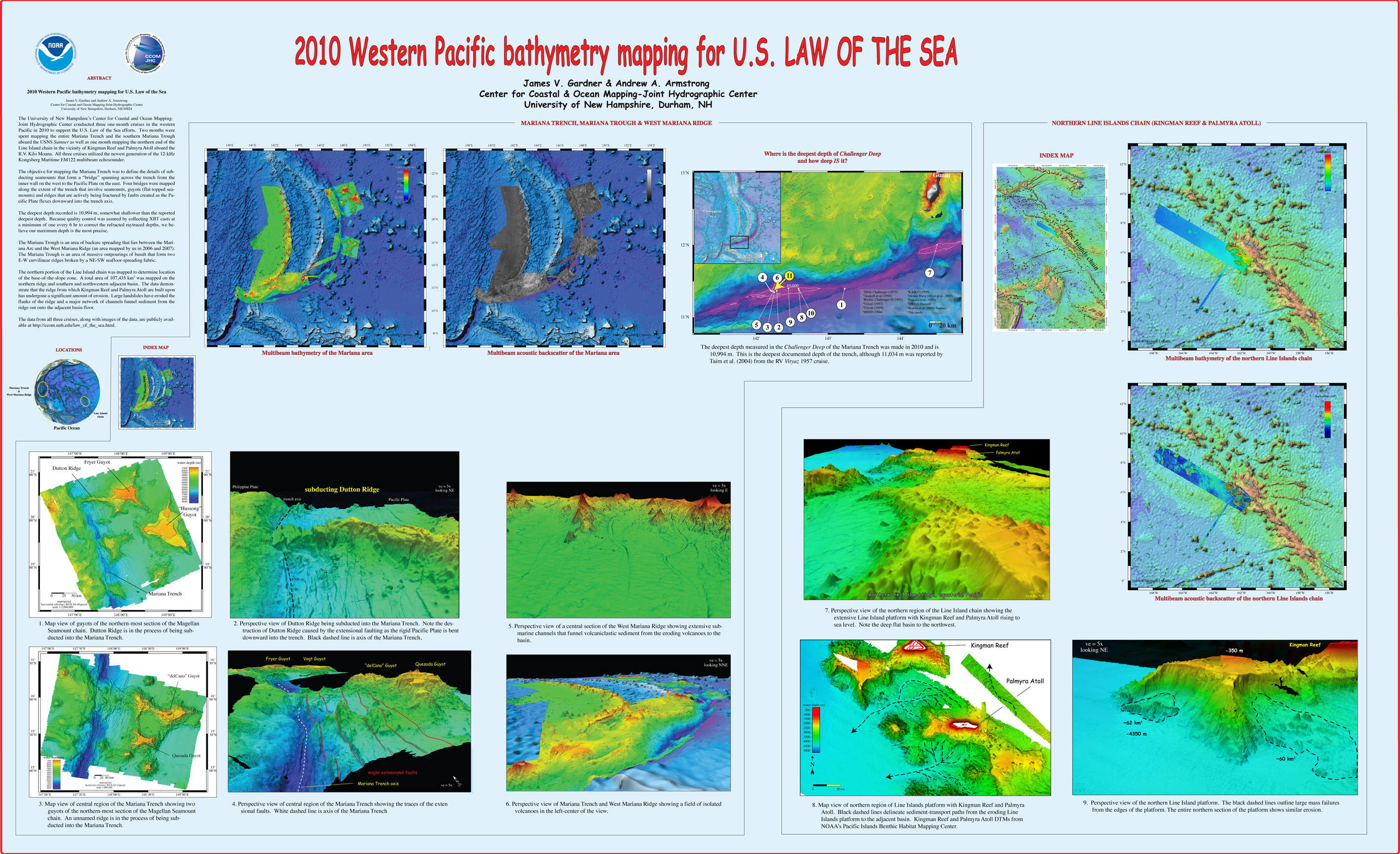
, “2010 Western Pacific bathymetry mapping for U.S. Law of the Sea”, U.S. Hydrographic Conference (US HYDRO). Tampa, FL, USA, 2011. Gardner_2011_USHYDRO_Western_Pacific_bathymetry_for_LOTS.jpg (3.5 MB)
, “Multibeam Bathymetry Mapping for U.S. UNCLOS Concerns: A Gold Mine for Marine Geology”, American Geophysical Union (AGU). San Francisco, CA, USA, 2007.
, “The Compilation and Analysis of Data Relevant to a U.S. Claim Under United Nations Law of the Sea Article 76: A Preliminary Report”, University of New Hampshire (UNH), Center for Coastal and Ocean Mapping (CCOM)/Joint Hydrographic Center (JHC), 2002. Mayer_02_Compilation_analysis_data_relevant_to_UNCLOS_76.pdf (7.88 MB)
, “The Compilation and Analysis of Data Relevant to a U.S. Claim Under United Nations Law of the Sea Article 76: Maps”, U.S. Congress, 2002.
, “From Seafloor Mapping to Geological Processes: New Insights in Marine Geomorphic Features Using High-Resolution Acoustic Imaging Techniques”, American Geophysical Union (AGU). San Francisco, CA, USA, 2011.
, “Western Pacific bathymetry mapping for U.S. Law of the Sea”, U.S. Hydro 2011. Tampa, FL, USA, 2011.
, “U.S. Extended Continental Shelf Cruise to Map Sections of the Mariana Trench and the Eastern and Southern Insular Margins of Guam and the Northern Mariana Islands”, Center for Coastal and Ocean Mapping / Joint Hydrographic Center, 2011. Armstrong_2011_cruise_report_SU10-02_Marianas.pdf (6.86 MB)
, “U.S. Law of the Sea Cruise to Map the Foot of the Slope and 2500-m Isobath of the U.S. Arctic Ocean Margin”, Center for Coastal and Ocean Mapping (CCOM)/Joint Hydrographic Center (JHC), 2011. Mayer_2011_cruise_report_HEALY1102.pdf (12.53 MB)
, “U.S. Law of the Sea cruise to map the foot of the slope and 2500-m isobath of the US Arctic Ocean margin, cruise report for 2009”, Center for Coastal and Ocean Mapping (CCOM)/Joint Hydrographic Center (JHC), 2009. Mayer_2009_cruise_report_HE0905.pdf (11.14 MB)
, “U.S. Law of the Sea Cruise to Map the Foot of the Slope and 2500-m Isobath of the U.S. Arctic Ocean Margin. Cruise Report for 2008”, University of New Hampshire (UNH), Center for Coastal and Ocean Mapping (CCOM)/Joint Hydrographic Center (JHC), 2008. Mayer_08_HEALY_0805_CRUISERPT.pdf (31.06 MB)
, “U.S. Law of the Sea Cruise to Map the Foot of the Slope and 2500-m Isobath of the U.S. Arctic Ocean Margin. Cruise Report for 2007”, University of New Hampshire (UNH), Center for Coastal and Ocean Mapping (CCOM)/Joint Hydrographic Center (JHC), 2007. Mayer_07_cruise_report_HE-0703.pdf (29.54 MB)
, “New Views of the Gulf of Alaska Margin Mapped for UNCLOS Applications”, University of New Hampshire (UNH), Center for Coastal and Ocean Mapping (CCOM)/Joint Hydrographic Center (JHC), 2005. Mayer_05_Gulf_of_Alaska_Margin_Mapped_for_UNCLOS_applications.pdf (65.49 KB)
, “Mapping Supports Potential Submission to U.N. Law of the Sea”, EOS Transactions, American Geophysical Union, vol. 87. American Geophysical Union , Washington DC, Washington DC, USA, pp. 157-159, 2006. Gardner_06_Eos_Mapping_supports_potential_submission_to_un_lots.pdf (270.7 KB)
, “The Mariana Trench: A New View Based on Multibeam Echosounding”, American Geophysical Union, Fall Meeting. San Francisco, CA, United States, 2011.
, “From the Arctic to the tropics: The U.S. UNCLOS bathymetryic mapping program.”, Canadian Hydrographic Conference (CHC). 2008.
, “US UNCLOS Multibeam Data: The Processing of Multibeam Bathymetry and Backcatter”, Hydro International, vol. 8. Geomatics Information & Trading Center - GITC, Lemmers, Amsterdam, The Netherlands, pp. 14-17, 2008. Fonseca_al_2008_hydro_intl.pdf (1.42 MB)
, “High Resolution Mapping in support of UNCLOS Article 76: Seeing the seafloor with new eyes”, U.S. Hydrographic Conference (US HYDRO). Norfolk, VA, USA, pp. 12-13, 2007.
, “U.S. Law of the Sea Cruise to Map and Sample the US Arctic Ocean Margin”, University of New Hampshire (UNH), Center for Coastal and Ocean Mapping (CCOM)/Joint Hydrographic Center (JHC), 2012. HEALY1202_FINAL_CRUISE REPORT.pdf (9.31 MB)
, “U.S. Extended Continental Shelf Cruise to Map Gaps in Kela and Karin Ridges, Johnston Atoll, Equatorial Pacific Ocean”, CCOM/JHC, Durham, NH, 2014. lots-cruise-report-km14-17-johnston-atoll.pdf (24.43 MB)
, “U.S. Extended Continental Shelf Cruise to Map Sections of the Mendocino Ridge”, University of New Hampshire, Durham, NH, 2014. cruise-report 2014-AT26-21-Mendocino-Ridge.pdf (12.87 MB)
, “U.S. Law of the Sea Cruise to Map the Foot of the Slope of the Northeast U.S. Atlantic Continental Margin: Leg 7”, Center for Coastal and Ocean Mapping / Joint Hydrographic Center, Durham, NH, 2012. cruise-report-RB12-1-Atlantic.pdf (2.26 MB)
, “U.S. Extended Continental Shelf Cruise to Map Necker Ridge and Vicinity, Central Pacific Ocean”, 2017. KM17-18-Cruise-Report.pdf (2.07 MB)
, “U.S. Extended Continental Shelf Cruise to Map Gulf of Alaska, Eastern Pacific”, Center for Coastal and Ocean Mapping / Joint Hydrographic Center, Durham, NH, 2018. KM1811-Cruise-Report.pdf (3.46 MB)
, “Extended Continental Shelf Mapping Cruise in Vicinity of Palmyra Atoll”, Center for Coastal and Ocean Mapping / Joint Hydrographic Center, Durham, NH, 2016. RB1601-line-islands-kingman-palmyra.pdf (7.63 MB)
, “NOAA's Role in Defining the U.S.”, Marine Technology Society Journal, vol. 49, No. 2. Marine Technology Society, Washington, D.C., pp. 204-210(7), 2015.
, “Shoreline mapping resolved from airborne LIDAR bathymetry (ALB) waveforms.”, Journal of Coastal Research, Special Issue: Applied LIDAR Techniques, vol. 62. Coastal Education & Research Foundation, Inc. [CERF], West Palm Beach, FL, USA, pp. 75-85, 2011.
, “Airborne Lidar Bathymetry Products for Shoreline Mapping”, Joint Airborne LIDAR Bathymetry Technical Center of Expertise Coastal Mapping and Charting Workshop (JALBTCX). San Francisco, CA, USA, 2008.
, “Development and Assessment of Airborne LIDAR Bathymetry Products for Shoreline Mapping”, Shallow Water Survey Conference (SWS). Durham, NH, USA, 2008.
, “Current Research on Airborne LIDAR Bathymetry (ALB) Shoreline Mapping”, FUDOTERAM Workshop Reminder on LiDAR Bathymetric Studies. Montreal, Quebec, Canada, 2009.
, “Hydrographic Survey Bottom Sampling Specifications: A Remote Sensing Perspective”, Canadian Hydrographic Conference (CHC). Quebec City, Quebec, Canada, 2010.
, “GIS Application to Post Super Storm Sandy Marine Debris Assessment and Categorization”, ESRI Ocean GIS Forum. p. Redlands, CA, 2016.
, “From Seafloor Mapping to Geological Processes: New Insights in Marine Geomorphic Features Using High-Resolution Acoustic Imaging Techniques”, American Geophysical Union (AGU). San Francisco, CA, USA, 2011.
, “U.S. Extended Continental Shelf Cruise to Map Sections of the Mariana Trench and the Eastern and Southern Insular Margins of Guam and the Northern Mariana Islands”, Center for Coastal and Ocean Mapping / Joint Hydrographic Center, 2011. Armstrong_2011_cruise_report_SU10-02_Marianas.pdf (6.86 MB)
, “GIS Application to Post Super Storm Sandy Marine Debris Assessment and Categorization”, ESRI Ocean GIS Forum. p. Redlands, CA, 2016.
, “U.S. Extended Continental Shelf Cruise to Map Sections of the Mendocino Ridge”, University of New Hampshire, Durham, NH, 2014. cruise-report 2014-AT26-21-Mendocino-Ridge.pdf (12.87 MB)
, “A Flexible, Low-Cost MOOS-IvP Based Platform for Marine Autonomy Research”, MOOS-DAWG. MIT, 2015. Manda_Presentation_LowCostASV.pdf (17.12 MB)
, “Shallow Water Multibeam Data Analysis of Complex Bedrock Geology in Penobscot Bay, Maine”, 8th Annual International Conference on High Resolution Surveys in Shallow Water. p. St. John's, NL, Canada, 2018.
, “CCOM-JHC Summer Hydro 2012: A High-Res Survey Under 12 Flags”, Eighth Annual GEBCO Bathymetric Science Day. Venice, Italy, 2013. ccom_poster_gebco_2013.pdf (730.59 KB)
, “U.S. Extended Continental Shelf Cruise to Map Sections of the Mariana Trench and the Eastern and Southern Insular Margins of Guam and the Northern Mariana Islands”, Center for Coastal and Ocean Mapping / Joint Hydrographic Center, 2011. Armstrong_2011_cruise_report_SU10-02_Marianas.pdf (6.86 MB)
, “The NOAA Joint Hydrographic Center and the UNH Center for Coastal and Ocean Mapping: An Educational and Research Partnership of the Federal Government”, IEEE Oceans, vol. 1. IEEE, Washington DC, Washington DC, USA, pp. 705-710, 2000. Armstrong_2000_IEEE_NOAA_JHC_An_Educational_Research_Partnership_of_Fed_Gov.pdf (3.91 MB)
, “The Navigation Surface: A New Database Approach to Creating Multiple Products from High-Density Surveys”, International Hydrographic Review, vol. 3. Geomatics Information & Trading Center - GITC, Lemmers, Amsterdam, The Netherlands, pp. 12-16, 2002.
, “Multibeam Bathymetric and Sediment Profiler Evidence for Ice Grounding on the Chukchi Borderland, Arctic Ocean”, Quaternary Research, vol. 63. Elsevier, New York, NY, USA, pp. 150-160, 2005.
, “On the use of historical bathymetric data to determine changes in bathymetry”, International Hydrographic Review, vol. 6. Geomatics Information & Trading Center - GITC, Lemmers, Amsterdam, The Netherlands, pp. 25-41, 2005.
, “Comparing Historical and Contemporary Hydrographic Data Sets: An Example from Great Bay, New Hampshire”, International Conference on High-Resolution Survey in Shallow Water (HRSSW). Portsmouth, NH, USA, pp. 0-0, 2001.
, “Error Estimation of Bathymetric Grid Models Derived from Historic and Contemporary Data Sets”, U.S. Hydrographic Conference (US HYDRO). Norfolk, VA, USA, pp. 0-17, 2001. Jakobsson_2001_THSOA_Error_estimation_of_bathymetric_grid_models_derived_from_historic_and_contemporary_datasets.pdf (226.25 KB)
, “Open Access Learning at Sea”, Canadian Hydrographic Conference (CHC). Toronto, Ontario, Canada, pp. 0-0, 2002.
, “Electronic Chart of the Future: The Hampton Roads Project”, U.S. Hydrographic Conference (US HYDRO). Biloxi, MS, USA, pp. 0-8, 2003.
, “New Paradigms for Hydrographic Data Processing and Products”, International Conference on High-Resolution Survey in Shallow Water (HRSSW). St. Andrews, New Brunswick, Canada, pp. 0-0, 2003.
, “New Multibeam Mapping of the Gulf of Maine”, GIS Conference. Cambridge, MA, USA, 2006.
, “On the Estimation of Errors in Sparse Bathymetric Geophysical Data Sets”, EOS Transactions, American Geophysical Union , vol. 82. Boston, MA, USA, pp. 0-0, 2001.
, “New Views of the U.S. Atlantic Margin Mapped for UNCLOS Applications”, EOS Transactions, American Geophysical Union , vol. 86. San Francisco, CA, USA, pp. 0-2, 2005. Gardner_05_AGU_US_Atlantic_Margin_Mapped_for_UNCLOS_applications.pdf (72.17 KB)
, “Okeanos Explorer - Aligning Today's Technology to a New Paradigm of Ocean Exploration”, FEMME - Kongsberg (users conference). Lisbon, Lisbon, Portugal, 2009.
, “Evaluating U.S. data holdings relevant to the definition of continental shelf limits”, in Legal and Scientific Aspects of Continental Shelf Limits, 8th ed., no. M.H Nordquist, J.N. Moore & T. Heider, Leiden, South Holland, The Netherlands: Martinus Nijhoff legacy_publishers, 2004, pp. 313-330.
, “Recent Mapping and Sampling on the Chukchi Borderland and Alpha/Medeleev Ridge”, American Geophysical Union (AGU), vol. 89. San Francisco, CA, USA, 2008.
, “Depth Adaptive Hydrographic Survey Behavior for Autonomous Surface Vessels”, IEEE/MTS Oceans '15. IEEE, National Harbor, MD, 2015. IEEEOceans_2015_Abstract_Manda.pdf (386.24 KB)
, “Shallow Water Multibeam Data Analysis of Complex Bedrock Geology in Penobscot Bay, Maine”, 8th Annual International Conference on High Resolution Surveys in Shallow Water. p. St. John's, NL, Canada, 2018.
, “The e-Learning Python for Ocean Mapping project - Empowering the Next Generation of Ocean Mappers with Effective Programming Skills”, 2020 Canadian Hydrographic Conference. Quebec City, Quebec, Canada, 2020. ePOM_CHC2010_abstract.pdf (36.64 KB)
, “The e-Learning Python for Ocean Mapping project - Empowering the Next Generation of Ocean Mappers with Effective Programming Skills”, 2020 Canadian Hydrographic Conference. Quebec City, Quebec, Canada, 2020. ePOM_CHC2010_abstract.pdf (36.64 KB)
, “U.S. Extended Continental Shelf Cruise to Map Sections of the Mendocino Ridge”, University of New Hampshire, Durham, NH, 2014. cruise-report 2014-AT26-21-Mendocino-Ridge.pdf (12.87 MB)
, “Intensity and Reflectance Mapping for Habitat Mapping and Seafloor Characterization Using the Superstorm Sandy Lidar Data”, JALBTCX. Silver Spring, MD, 2016.
, “U.S. Law of the Sea Cruise to Map the Foot of the Slope of the Northeast U.S. Atlantic Continental Margin: Leg 7”, Center for Coastal and Ocean Mapping / Joint Hydrographic Center, Durham, NH, 2012. cruise-report-RB12-1-Atlantic.pdf (2.26 MB)
, “Satellite-Derived Bathymetry”, in The IHO-IOC GEBCO Cook Book (IHO Publication B-11 and IOC Manuals and Guides, 63), 11.1.16th ed., Monaco, Monaco Cedex, Monaco: International Hydrographic Office (IHO)/ International Ocean Commision (IOC), 2016, pp. 346-422.
, “Standardized Geomorphic Classification of Seafloor Within the United States Atlantic Canyons and Continental Margin”, Frontiers in Marine Science, vol. 7(9). pp. 1-9, 2020.
, “Seamounts, Submarine Channels, and New Discoveries”, Journal of Ocean Technology, vol. 10, No. 3. Fisheries and Marine Institute of Memorial University of Newfoundland, St. John's, Newfoundland, Canada, pp. 1-14, 2015. Armstrong-et-al-2015-ocean-tech.pdf (557.4 KB)
, “Shallow Water Multibeam Data Analysis of Complex Bedrock Geology in Penobscot Bay, Maine”, 8th Annual International Conference on High Resolution Surveys in Shallow Water. p. St. John's, NL, Canada, 2018.
, “An Ultrahigh-Latitude Submarine Channel: Northern Chukchi Rise”, in Atlas of Submarine Glacial Landforms: Modern, Quaternary and Ancient., vol. Memoirs, London, UK: The Geological Society of London, 2016, pp. 391-392.
, “Seamounts, Submarine Channels, and New Discoveries”, Journal of Ocean Technology, vol. 10, No. 3. Fisheries and Marine Institute of Memorial University of Newfoundland, St. John's, Newfoundland, Canada, pp. 1-14, 2015. Armstrong-et-al-2015-ocean-tech.pdf (557.4 KB)
, “GIS Application to Post Super Storm Sandy Marine Debris Assessment and Categorization”, ESRI Ocean GIS Forum. p. Redlands, CA, 2016.
, “Update on NOAA's IOCM Sandy Project for Charting and Habitat Mapping Using Topobathymetric Lidar Surveys”, 16th Annual JALBTCX Airborne Coastal Mapping and Charting Workshop. Corvallis, OR, 2015.
, “Intensity and Reflectance Mapping for Habitat Mapping and Seafloor Characterization Using the Superstorm Sandy Lidar Data”, JALBTCX. Silver Spring, MD, 2016.
, “Bathymetric Attributed Grids (BAGs): Discovery of Marine Datasets and Geospatial Metadata Visualization”, Canadian Hydrographic Conference (CHC). Quebec City, Quebec, Canada, 2010.
, “Update on NOAA's IOCM Sandy Project for Charting and Habitat Mapping Using Topobathymetric Lidar Surveys”, 16th Annual JALBTCX Airborne Coastal Mapping and Charting Workshop. Corvallis, OR, 2015.
, “From the Arctic to the tropics: The U.S. UNCLOS bathymetryic mapping program.”, Canadian Hydrographic Conference (CHC). 2008.
, “U.S. Law of the Sea Cruise to Map and Sample the US Arctic Ocean Margin”, University of New Hampshire (UNH), Center for Coastal and Ocean Mapping (CCOM)/Joint Hydrographic Center (JHC), 2012. HEALY1202_FINAL_CRUISE REPORT.pdf (9.31 MB)
, “Hatteras Transverse Canyon, Hatteras Outer Ridge and Environs of the U.S. Atlantic Margin: A View from Multibeam Bathymetry and Backscatter”, Marine Geology, vol. 371. Elsevier, pp. 18-32, 2015. Gardner-et-al -2015-Hatteras-Transverse-Canyon.pdf (7.35 MB)
, “Performance Evaluation of the Velodyne VLP-16 System for Feature-Surface Surveying”, 2016 Canadian Hydrographic Conference. Canadian Hydrographic Association, Halifax, Nova Scotia, Canada, 2016.
, “Performance Evaluation of the Velodyne VLP-16 System for Feature-Surface Surveying”, 2016 Canadian Hydrographic Conference. Canadian Hydrographic Association, Halifax, Nova Scotia, Canada, 2016.


