Publications
, “Geological interpretation of a low-backscatter anomaly found on the New Jersey continental margin”, Marine Geology, vol. 326-328. Elsevier, pp. 46-54, 2012. Sweeney-et-al-2012.pdf (3.34 MB)
, “Geomorphometry and processes that built Necker Ridge, central North Pacific Ocean”, Marine Geology, vol. 346. Elsevier, pp. 310-325, 2013. Necker_Ridge_Marine_Geology_published.pdf (4.66 MB)
, “Geomorphometry and processes that built Necker Ridge, central North Pacific Ocean”, Marine Geology, vol. 346. Elsevier, pp. 310-325, 2013. Necker_Ridge_Marine_Geology_published.pdf (4.66 MB)
, “Hatteras Transverse Canyon, Hatteras Outer Ridge and Environs of the U.S. Atlantic Margin: A View from Multibeam Bathymetry and Backscatter”, Marine Geology, vol. 371. Elsevier, pp. 18-32, 2015. Gardner-et-al -2015-Hatteras-Transverse-Canyon.pdf (7.35 MB)
, “From the Arctic to the tropics: The U.S. UNCLOS bathymetryic mapping program.”, Canadian Hydrographic Conference (CHC). 2008.
, “Geological interpretation of a low-backscatter anomaly found on the New Jersey continental margin”, Marine Geology, vol. 326-328. Elsevier, pp. 46-54, 2012. Sweeney-et-al-2012.pdf (3.34 MB)
, “The Role of Deep-Water Sedimentary Processes in Shaping a Continental Margin: The Northwest Atlantic”, Marine Geology, vol. 393. Elsevier, pp. 245-259, 2017. Mosher-et-al-2017-Atlantic-margin.pdf (2.8 MB)
, “Geomorphometry and processes that built Necker Ridge, central North Pacific Ocean”, Marine Geology, vol. 346. Elsevier, pp. 310-325, 2013. Necker_Ridge_Marine_Geology_published.pdf (4.66 MB)
, “Seamounts, Submarine Channels, and New Discoveries”, Journal of Ocean Technology, vol. 10, No. 3. Fisheries and Marine Institute of Memorial University of Newfoundland, St. John's, Newfoundland, Canada, pp. 1-14, 2015. Armstrong-et-al-2015-ocean-tech.pdf (557.4 KB)
, “An Ultrahigh-Latitude Submarine Channel: Northern Chukchi Rise”, in Atlas of Submarine Glacial Landforms: Modern, Quaternary and Ancient., vol. Memoirs, London, UK: The Geological Society of London, 2016, pp. 391-392.
, “Geological interpretation of a low-backscatter anomaly found on the New Jersey continental margin”, Marine Geology, vol. 326-328. Elsevier, pp. 46-54, 2012. Sweeney-et-al-2012.pdf (3.34 MB)
, “Seamounts, Submarine Channels, and New Discoveries”, Journal of Ocean Technology, vol. 10, No. 3. Fisheries and Marine Institute of Memorial University of Newfoundland, St. John's, Newfoundland, Canada, pp. 1-14, 2015. Armstrong-et-al-2015-ocean-tech.pdf (557.4 KB)
, “Seafloor characterization using airborne hyperspectral co-registration procedures independent from attitude and positioning sensors”, Coastal Geotools 2011. Myrtle Beach, SC, USA, 2011.
, “High-resolution Multibeam Mapping and Habitat Characterization of Topographic Features in the Northwest Gulf of Mexico”, U.S. Hydrographic Conference (US HYDRO). Biloxi, MS, USA, pp. 0-0, 2003.
, “Lake Tahoe's submerged record of active faulting is characteristic of the Basin and Range”, Geological Society of America (GSA), vol. 33. Cedar City, UT, USA, pp. 0-0, 2002.
, “Characteristics of Several Tsunamigenic Submarine Landslides”, in Submarine Mass Movements and Their Consequences: First International Symposium, no. J. Locat & J. Mienert, Amsterdam, North Holland, The Netherlands: Kluwer Academic, 2003, pp. 357-366.
, “Ground truth operation for seafloor characterization”, Coastal Geotools 2011. Myrtle Beach, SC, USA, 2011.
, “Fine-scale sediment distribution at the mouth of the Merrimack River”, Coastal Geotools 2011. Myrtle Beach, SC, USA, 2011.
, “Submarine Landslides on the Upper Southeast Australian Passive Continental Margin – Preliminary Findings”, 11th International Symposium on Landslides. Banff, Alberta, Canada, 2012.
, “Physical Properties and Age of Continental Slope Sediments Dredged from the East Australian Continental Margin - Implications for Timing of Slope Failure”, 11th International Symposium on Landslides. Banff, Alberta, Canada, 2012.
, “Standardized Geomorphic Classification of Seafloor Within the United States Atlantic Canyons and Continental Margin”, Frontiers in Marine Science, vol. 7(9). pp. 1-9, 2020.
, “The Morphometry of the Deep-Water Sinuous Mendocino Channel and the Immediate Environs, Northeastern Pacific Ocean”, geosciences, vol. 7, 4. MDPI, 2017. gardner-deep-water-sinuous-channel-geosciences-2017.pdf (2.07 MB)
, “U.S. Law of the Sea Cruise to Map the Foot of the Slope of the Northeast U.S. Atlantic Continental Margin: Leg 7”, Center for Coastal and Ocean Mapping / Joint Hydrographic Center, Durham, NH, 2012. cruise-report-RB12-1-Atlantic.pdf (2.26 MB)
, “Cascades and Plunge Pools in the Gulf of Alaska”, in Atlas of Submarine Glacial Landforms: Modern, Quaternary and Ancient, vol. Memoirs, London, UK: Geological Society of London , 2016, pp. 389-390.
, “Morphology and processes in Lake Tahoe (California-Nevada)”, Geological Society of America Bulletin (GSAB), vol. 112. The Geological Society of America (GSA), pp. 736-746, 2000.
, “Predicting Seafloor Facies from Multibeam Bathymetry and Backscatter Data”, Photogrammetric Engineering and Remote Sensing, vol. 70. ASPRS: The Imaging and Geospatial Information Society, Bethesda, MD, USA, pp. 1081-1091, 2004.
, “Drowned barrier-island complexes and shelf-edge deltas on the northwest Florida outer continental self”, Geomorphology, vol. 64. Elsevier, New York, NY, USA, pp. 133-166, 2004.
, “High-Resolution Multibeam Bathymetry and Acoustic Backscatter of Selected Northwestern Gulf of Mexico Outer Shelf Banks”, Gulf of Mexico Science and International Journal, vol. 23. Marine Environmental Sciences Consortium of Alabama, pp. 5-29, 2005.
, “Multibeam Bathymetric and Sediment Profiler Evidence for Ice Grounding on the Chukchi Borderland, Arctic Ocean”, Quaternary Research, vol. 63. Elsevier, New York, NY, USA, pp. 150-160, 2005.
, “A 60 k.y. record of extension across the western boundary of the Basin and Range Province: Estimate of slip-rates from offset shoreline terraces and a catastrophic slide beneath Lake Tahoe”, Geology, vol. 33. The Geological Society of America (GSA), pp. 365-368, 2005.
, “Geophysical Insights into the Transition Fault Debate: Propagating Strike Slip in Response to Stalling Yakutat Block Subduction in the Gulf of Alaska”, Geology, vol. 35. The Geological Society of America (GSA), pp. 763-766, 2007.
, “Drowned shelf-edge delta complexes and barrier islands and related features along the outer continental shelf north of the head of De Sotot Canyon, NE Gulf of Mexico”, Geomorphology, vol. 89. Elsevier, New York, NY, USA, pp. 370-390, 2007.
, “Plume 1400 Meters High Discovered at the Seafloor off the Northern California Margin”, EOS Transactions, American Geophysical Union, vol. 90. American Geophysical Union , Washington DC, Washington DC, USA, pp. 275-275, 2009. Gardner_2009_EOS_plume_discovered.pdf (140.14 KB)
, “Interactive 3-D Visualization: A tool for seafloor navigation, exploration, and engineering”, IEEE Oceans. Providence, RI, USA, pp. 913-920, 2000.
, “Interactive 3-D Visualization and Analysis of Multi-sensor, Multi-resolution Data Sets”, International Conference on High-Resolution Survey in Shallow Water (HRSSW). Portsmouth, NH, USA, pp. 0-0, 2001.
, “Interactive 3-D Visualization and Exploration of Deepwater Geohazards”, Offshore Technology Conference (OTC). Houston, TX, USA, pp. 0-11, 2001.
, “Geometric and Radiometric Correction of Multibeam Backscatter Derived from Reson 8101 Systems”, Canadian Hydrographic Conference (CHC). Toronto, Ontario, Canada, pp. 1-22, 2002.
, “A Reappraisal of Deepwater Reefs Along the NW Florida Outer Continental Shelf”, UC Santa Cruz Marine Sciences Seminar . St. Andrews, New Brunswick, Canada, pp. 0-0, 2002.
, “Deep-water 'Reefs' of the Northern Gulf of Mexico”, ACM Computer Human Interaction (CHI). San Jose, CA, USA, 2002.
, “The Marine Geology off Southern California”, Geological Society of America (GSA). St. Andrews, New Brunswick, Canada, pp. 0-0, 2004.
, “Visualizing the Marine Geology off Southern California”, Geological Society of America (GSA). St. Andrews, New Brunswick, Canada, pp. 0-0, 2004.
, “Bathymetry of West Mariana Ridge and Eastern Parece Vela Basin: A Lot of Surprises, Subduction Factory Studies in the Izu-Bonin-Mariana Arc System”, Results and Future Plans Conference. Honolulu, HI, USA, 2007.
, “Southeast Australia: A Cenozoic continental margin dominated by mass transport”, Submarine Mass Movements and Their Consequences. Austin, TX, USA, pp. 491-502, 2009. Boyd_2009_SMMTC_Southeast_Australia.pdf (4.96 MB)
, “4D Multimodal Visualization and Analysis of Seafloor Vents and Plumes”, Canadian Hydrographic Conference (CHC). Quebec City, Quebec, Canada, pp. 1-2, 2010.
, “High-resolution Multibeam Mapping of Crater Lake, Oregon”, EOS Transactions, American Geophysical Union , vol. 81. San Francisco, CA, USA, pp. 0-0, 2000.
, “Differential Strain Accumulation Across Lake Tahoe as Measured From Submerged Paleo-shorelines”, EOS Transactions, American Geophysical Union , vol. 82. San Francisco, CA, USA, pp. 0-0, 2001.
, “Crater Lake Revealed: Using GIS to Visualize and Analyze Post Caldera Volcanoes Beneath Crater Lake”, EOS Transactions, American Geophysical Union , vol. 82. San Francisco, CA, USA, pp. 0-0, 2001.
, “Assessing Damage on the Major Submarine Deltas of Southern Puget Sound After the 2001 Nisqually Earthquake Using High-Resolution Seafloor Multibeam Mapping”, Geological Society of America (GSA), vol. 34. Corvallis, OR, USA, pp. 0-0, 2002.
, “New Views of the U.S. Atlantic Margin Mapped for UNCLOS Applications”, EOS Transactions, American Geophysical Union , vol. 86. San Francisco, CA, USA, pp. 0-2, 2005. Gardner_05_AGU_US_Atlantic_Margin_Mapped_for_UNCLOS_applications.pdf (72.17 KB)
, “Significant Tectonic and Climatic Events for the Yakutat Block Collision, Gulf of Alaska: Pleistocene Glacial Intensification in the St. Elias Mountains and the Relationship Between the Fairweather and Transition Faults”, Geological Society of America: Backbone of the Americas (GSA). Mendoza, Mendoza, Argentina, pp. 1-2, 2006. Gulick_2010_GSA_Significant_tectonic_climatic_events_AK.pdf (21.43 KB)
, “Ground-truth Results of Comparison or Airborne LIDAR Bathymetry in Subtidal Coastal Environments”, American Geophysical Union (AGU), vol. 89. San Francisco, CA, USA, 2008.
, “Physiography of the Eastern Mendocino Ridge, NE Pacific Ocean”, American Geophysical Union (AGU). San Francisco, CA, USA, 2009.
, “More than the Bottom: Multibeam Sonars and Water-column Imaging”, American Geophysical Union (AGU). San Francisco, CA, USA, pp. 1-1, 2010.
, “Sediment Characteristics of Submarine Landslides on the Upper East Australian Continental Margin--Preliminary findings”, American Geophysical Union (AGU). San Francisco, CA, USA, pp. 1-1, 2010.
, “Physical Properties and Age of Mid-slope Sediments Dredged from the Eastern Australian Continental Margin--Implication for Continental Margin Erosional Processes”, American Geophysical Union (AGU). San Francisco, CA, USA, pp. 1-1, 2010.
, “Bathymetry and Acoustic Backscatter of Selected Areas of the Outer Continental Shelf, Northwestern Gulf of Mexico”, U.S. Geological Survey (USGS), 2002.
, “Bathymetry and Selected Perspective Views Offshore Greater Los Angeles, CA”, U.S. Geological Survey (USGS), 2002.
, “Bathymetry and Acoustic Backscatter of the Mid and outer continental shelf, head of De Soto Canyon, Northeastern Gulf of Mexico”, U.S. Geological Survey (USGS), 2002.
, “Multibeam Mapping of the Los Angeles, California Margin”, U.S. Geological Survey (USGS), 2002.
, “Multibeam Mapping of the West Florida Shelf, Gulf of Mexico”, U.S. Geological Survey (USGS), 2002.
, “Multibeam Mapping of the Pinnacles Region, Gulf of Mexico”, U.S. Geological Survey (USGS), 2002.
, “Multibeam Mapping of Selected Areas of the Outer Continental Shelf, Northwestern Gulf of Mexico - Data, Images and GIS”, U.S. Geological Survey (USGS), 2002.
, “Bathymetry and Acoustic Backscatter of the Mid and Outer Continental Shelf, Head of De Soto Canyon, Northeastern Gulf of Mexico Data, Images, and GIS”, U.S. Geological Survey (USGS), 2003.
, “Crater Lake Revealed - Investigations I-2790”, U.S. Geological Survey (USGS), 2003.
, “Bathymetry and Selected Perspective Views of 6 Reef and Coastal Areas in Northern Lake Michigan”, U.S. Geological Survey (USGS), 2003.
, “Visualizing the Geology of Lake Trout Spawning Sites: Northern Lake Michigan”, U.S. Geological Survey (USGS), 2004.
, “Predicted Seafloor Facies of Central Santa Monica Bay, California”, U.S. Geological Survey (USGS), 2004.
, “Los Angeles and San Diego Margin High-resolution Multibeam Bathymetry and Backscatter Data”, U.S. Geological Survey (USGS), 2004.
, “UNCLOS Mapping of Marianas Western Margin, Technical Report”, University of New Hampshire (UNH), Center for Coastal and Ocean Mapping (CCOM)/Joint Hydrographic Center (JHC), 2006.
, “The Seafloor off Greater Los Angeles: Visualizing Gigabytes of Data”, EOS Transactions, American Geophysical Union, vol. 83, pp. 0-0, 2002.
, “New Iinsights into the Transition Fault Debate: Propagating Strike-slip in Response to Stalled Subduction in the Gulf of Alaska”, Geology, vol. 35. The Geological Society of America (GSA), pp. 763-766, 2007. Gulick et al, 2007.pdf (704.2 KB)
, “Submarine landslides of San Pedro Sea Valley, southwest of Long Beach, California”, Marine Geology, vol. 203. Elsevier, New York, NY, USA, pp. 261-268, 2004. Bohannon-Gardner-2004.pdf (891.57 KB)
, “Geomorphology acoustic backscatter and processes in Santa Monica Bay from multibeam mapping”, Marine Environmental Research, vol. 56. Elsevier, New York, NY, USA, pp. 15-46, 2003. Gardner-et-al-2003-Santa-Monica.pdf (2.08 MB)
, “Mapping Southern Puget Sound Delta Fronts after the 2001 Nisqually Earthquake”, EOS Transactions, American Geophysical Union, vol. 82. American Geophysical Union , Washington DC, Washington DC, USA, pp. 485-489, 2001. Gardner-et-al-Puget-Sound-2001.pdf (487.42 KB)
, “Physiography and Late Quaternary-Holocene Processes of Northeastern Gulf of Mexico Outer Continental Shelf off Mississippi and Alabama”, Gulf of Mexico Science and International Journal. Marine Environmental Sciences Consortium of Alabama, pp. 132-157, 2001. Gardner-Pinnacles-2001.pdf (14.48 MB)
, “Shelf-edge Deltas and Drowned Barrier-island Complexes on the Northwest Florida Outer Continental Shelf”, Geomorphology, vol. 64. Elsevier, New York, NY, USA, pp. 133-166, 2005. Gardner-et-al-NWFlaPUBLISHED.pdf (8.56 MB)
, “Recent Mapping and Sampling on the Chukchi Borderland and Alpha/Medeleev Ridge”, American Geophysical Union (AGU), vol. 89. San Francisco, CA, USA, 2008.
, “The limits of spatial resolution achievable using a 30kHz multibeam sonar: model predictions and field results”, IEEE Oceans, vol. 3. IEEE, Washington DC, Washington DC, USA, pp. 1823-1827, 1998.
, “Mapping a Continental Shelf and Slope in the 1990s: A Tale of Three Multibeams”, Shallow Water Survey Conference (SWS). Sydney, Australia, pp. 0-11, 1999.
, “The Role of Deep-Water Sedimentary Processes in Shaping a Continental Margin: The Northwest Atlantic”, Marine Geology, vol. 393. Elsevier, pp. 245-259, 2017. Mosher-et-al-2017-Atlantic-margin.pdf (2.8 MB)
, “Geomorphometry and processes that built Necker Ridge, central North Pacific Ocean”, Marine Geology, vol. 346. Elsevier, pp. 310-325, 2013. Necker_Ridge_Marine_Geology_published.pdf (4.66 MB)
, “Southeast Australia: A Cenozoic Continental Margin Dominated by Mass Transport”, in Submarine Mass Movements and Their Consequences, vol. 28, no. Mosher, Shipp, Moscardelli, Chaytor, Baxtor, Lee & Urgeles, New York, NY, USA: Springer Science, 2010, pp. 491-502.
, “Utilizing New Multibeam Sonar Datasets to Map Potential Locations of Sensitive Benthic Habitats in the U.S. Atlantic Extended Continental Shelf”, 2013 Fall Meeting, American Geophysical Union (AGU). San Francisco, CA, 2013.
, “Geomorphometry and processes that built Necker Ridge, central North Pacific Ocean”, Marine Geology, vol. 346. Elsevier, pp. 310-325, 2013. Necker_Ridge_Marine_Geology_published.pdf (4.66 MB)
, “Geological interpretation of a low-backscatter anomaly found on the New Jersey continental margin”, Marine Geology, vol. 326-328. Elsevier, pp. 46-54, 2012. Sweeney-et-al-2012.pdf (3.34 MB)
, “The Role of Deep-Water Sedimentary Processes in Shaping a Continental Margin: The Northwest Atlantic”, Marine Geology, vol. 393. Elsevier, pp. 245-259, 2017. Mosher-et-al-2017-Atlantic-margin.pdf (2.8 MB)
, “Geomorphometry and processes that built Necker Ridge, central North Pacific Ocean”, Marine Geology, vol. 346. Elsevier, pp. 310-325, 2013. Necker_Ridge_Marine_Geology_published.pdf (4.66 MB)
, “The Role of Deep-Water Sedimentary Processes in Shaping a Continental Margin: The Northwest Atlantic”, Marine Geology, vol. 393. Elsevier, pp. 245-259, 2017. Mosher-et-al-2017-Atlantic-margin.pdf (2.8 MB)
, “From Seafloor Mapping to Geological Processes: New Insights in Marine Geomorphic Features Using High-Resolution Acoustic Imaging Techniques”, American Geophysical Union (AGU). San Francisco, CA, USA, 2011.
, “The seafloor a key factor in lidar bottom detection”, IEEE Journal of Oceanic Engineering. IEEE, Washington DC, Washington DC, USA, 2003.
, “The Seafloor: A Key Factor in Lidar Bottom Detection”, IEEE Transactions on Geoscience and Remote Sensing, vol. 49. IEEE, Washington DC, Washington DC, USA, pp. 1150-1157, 2011. Peeri_2010_IEEE_The_Seafloor-A_key_factor_in_Lidar_bottom_detection.pdf (801.32 KB)
, “The seafloor as key component for the success of lidar in bottom detection”, Joint Airborne LIDAR Bathymetry Technical Center of Expertise Coastal Mapping and Charting Workshop (JALBTCX). Seattle, WA, USA, 2007.
, “Validating coastal flooding models using ALB-derived shorelines”, Canadian Hydrographic Conference (CHC). Victoria, British Columbia, Canada, 2008.
, “Lake Tahoe bottom characteristics extracted from SHOALS lidar waveform data and compared to backscatter data from a Multibeam echo sounder”, EOS Transactions, American Geophysical Union , vol. 83. San Francisco, CA, USA, pp. 0-0, 2002.
, “Shoreline Mapping Using LIDAR Red-channel Waveforms”, American Geophysical Union (AGU). San Francisco, CA, USA, 2006.
, “Identifying subtidal coastal environments using airborne lidar bathymetry (ALB)”, American Geophysical Union (AGU). San Francisco, CA, USA, 2007.
, “Evaluation of Airborne LIDAR Bathymetry (ALB) in Sub-tidal Coastal Environments”, Joint Airborne LIDAR Bathymetry Technical Center of Expertise Coastal Mapping and Charting Workshop (JALBTCX). Portland, OR, USA, 2009.
, “Hydrographic Survey Bottom Sampling Specifications: A Remote Sensing Perspective”, Canadian Hydrographic Conference (CHC). Quebec City, Quebec, Canada, 2010.
, “Lake Tahoe Bottom Characteristics Extracted from SHOALS Lidar Waveform Data and Compared to Backscatter Data From a Multibeam Echo Sounder”, 2002 Fall Meeting, American Geophysical Union. American Geophysical Union , San Francisco, CA, 2002. Elston_2002_AGU_Lake_tahoe_bottom_chars_from_shoals_lidar.jpg (766 KB)
, “U.S. Law of the Sea Mapping”, Hydro International, vol. 9. Geomatics Information & Trading Center - GITC, Lemmers, Amsterdam, The Netherlands, pp. 42-45, 2005. Gardner_05_Hydro_US_Law_of_the_Sea_Mapping.pdf (16.23 MB)
, “The West Mariana Ridge, Western Pacific Ocean: Geomorphology and Processes from New Multibeam Data”, Geological Society of America Bulletin (GSAB), vol. 122. The Geological Society of America (GSA), pp. 1378-1388, 2010. Gardner_2010_GSAB_West_Mariana_Ridge_Geomorphology_and_processes_from_new_multibeam_data.pdf (4.28 MB)
, “Seafloor Mapping In The Arctic:Support For a Potential US Extended Continental Shelf”, International Hydrographic Review, vol. 3. Geomatics Information & Trading Center - GITC, Lemmers, Amsterdam, The Netherlands, pp. 14-23, 2010. Mayer_2010_IHR_Sea_Floor_Mapping_In_The_Arctic.pdf (684.1 KB)
, “New Views of the U.S. Continental Margins”, U.S. Hydrographic Conference (US HYDRO). San Diego, CA, USA, pp. 29-31, 2005. Gardner_05_USHydro_New_views_of_US_continental_margins.pdf (579.95 KB)
, “From the Arctic to the Tropics: The U.S. UNCLOS Bathymetric Mapping Program”, Canadian Hydrographic Conference (CHC). Victoria, British Columbia, Canada, pp. 1-11, 2008. Gardner_08_CHC_From_the_Arctice_to_the_Tropics.pdf (1.2 MB)
, “Mapping in the Arctic Ocean in Support of a Potential Extended Continental Shelf”, U.S. Hydrographic Conference (US HYDRO). Norfolk, VA, USA, pp. 0-13, 2009. Mayer_09_USHYDRO_Mapping_in_Arctic_in_support_of_potential_ecs.pdf (1.06 MB)
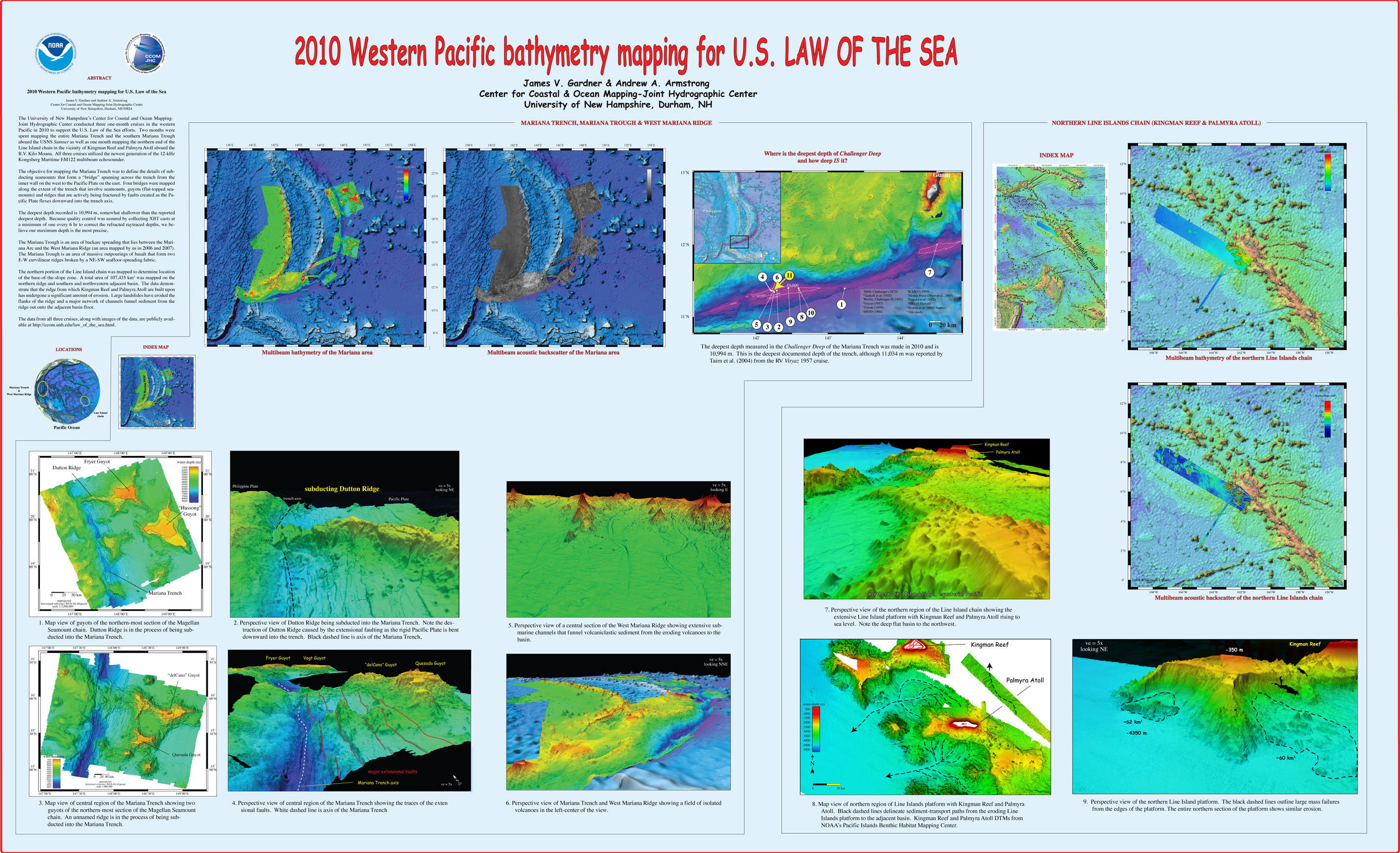
, “2010 Western Pacific bathymetry mapping for U.S. Law of the Sea”, U.S. Hydrographic Conference (US HYDRO). Tampa, FL, USA, 2011. Gardner_2011_USHYDRO_Western_Pacific_bathymetry_for_LOTS.jpg (3.5 MB)
, “Multibeam Bathymetry Mapping for U.S. UNCLOS Concerns: A Gold Mine for Marine Geology”, American Geophysical Union (AGU). San Francisco, CA, USA, 2007.
, “Seafloor Terrain Analysis and Geomorphology of the Greater Los Angeles Margin and San Pedro Basin, Southern California”, in Earth Science in the Urban Ocean: The Southern California Continental Borderland., no. H.J. Lee & W.R. Normark, The Geological Society of America (GSA), 2009, pp. 9-28. Dartnell_2009_GSA_Seafloor_terrain_analysis_and_geomorphology_LA_margin.pdf (4.33 MB)
, “From Seafloor Mapping to Geological Processes: New Insights in Marine Geomorphic Features Using High-Resolution Acoustic Imaging Techniques”, American Geophysical Union (AGU). San Francisco, CA, USA, 2011.
, “Western Pacific bathymetry mapping for U.S. Law of the Sea”, U.S. Hydro 2011. Tampa, FL, USA, 2011.
, “U.S. Law of the Sea Cruise to Complete the Mapping of Necker Ridge, Central Pacific Ocean”, Center for Coastal and Ocean Mapping (CCOM)/Joint Hydrographic Center (JHC), 2011. Gardner_2011_Cruise_Report_KM1121_NeckerRidge.pdf (2.31 MB)
, “U.S. Law of the Sea cruises to map sections of the Mariana Trench and the eastern and southern insular margins of Guam and the Northern Mariana Islands”, University of New Hampshire (UNH), Center for Coastal and Ocean Mapping (CCOM)/Joint Hydrographic Center (JHC), 2010. Gardner_2010_cruise_report_SU10-1_Marianas.pdf (4.88 MB)
, “U.S. Law of the Sea Cruise to Map the Foot of the Slope and 2500-m Isobath of the Florida Escarpment and Sigsbee Escarpment, Northern Gulf of Mexico Continental Marg. Cruise Report”, University of New Hampshire (UNH), Center for Coastal and Ocean Mapping (CCOM)/Joint Hydrographic Center (JHC), 2007. Gardner_07_cruise_report_NR07-1.pdf (21.74 MB)
, “U.S. Law of the Sea Cruise to Map the Western Insular Margin and 2500-m Isobath of Guam and the Northern Mariana Islands. Cruise Report”, University of New Hampshire (UNH), Center for Coastal and Ocean Mapping (CCOM)/Joint Hydrographic Center (JHC), 2007. Gardner_07_cruise_report_BD07-1.pdf (2.54 MB)
, “Law of the Sea Cruise to Map the Western Insular Margin and 2500-m Isobath of Guam and the Northern Mariana Islands. Cruise Report”, University of New Hampshire (UNH), Center for Coastal and Ocean Mapping (CCOM)/Joint Hydrographic Center (JHC), 2006. Gardner_06_cruise_report_BD06-1.pdf (2.02 MB)
, “U.S. Law of the Sea Cruise to Map the Foot of the Slope and 2500-m Isobath of the Northeast U.S. Atlantic Continental Margin: Legs 4 and 5. Cruise Report”, University of New Hampshire (UNH), Center for Coastal and Ocean Mapping (CCOM)/Joint Hydrographic Center (JHC), 2005. Cartwright_05_cruise_report_PF05-1.pdf (1.59 MB)
, “U.S. Law of the Sea Cruise to Map the Foot of the Slope and 2500-m Isobath of the Northeast US Atlantic Continental Margin: Legs 1, 2 and 3. Cruise Report”, University of New Hampshire (UNH), Center for Coastal and Ocean Mapping (CCOM)/Joint Hydrographic Center (JHC), 2004. Gardner_04_cruise_report_HEN04-1.pdf (2.24 MB)
, “Report on the LOTS Cruise to Map Foot of the Slope and 2500-m Isobath of Bowers Ridge and Beringian Margin, Bering Sea. Cruise Report”, University of New Hampshire (UNH), Center for Coastal and Ocean Mapping (CCOM)/Joint Hydrographic Center (JHC), 2003. Gardner_03_cruise_report_DA0301.pdf (8.01 MB)
, “New Views of the Gulf of Alaska Margin Mapped for UNCLOS Applications”, University of New Hampshire (UNH), Center for Coastal and Ocean Mapping (CCOM)/Joint Hydrographic Center (JHC), 2005. Mayer_05_Gulf_of_Alaska_Margin_Mapped_for_UNCLOS_applications.pdf (65.49 KB)
, “Mapping Supports Potential Submission to U.N. Law of the Sea”, EOS Transactions, American Geophysical Union, vol. 87. American Geophysical Union , Washington DC, Washington DC, USA, pp. 157-159, 2006. Gardner_06_Eos_Mapping_supports_potential_submission_to_un_lots.pdf (270.7 KB)
, “The Mariana Trench: A New View Based on Multibeam Echosounding”, American Geophysical Union, Fall Meeting. San Francisco, CA, United States, 2011.
, “From the Arctic to the tropics: The U.S. UNCLOS bathymetryic mapping program.”, Canadian Hydrographic Conference (CHC). 2008.
, “US UNCLOS Multibeam Data: The Processing of Multibeam Bathymetry and Backcatter”, Hydro International, vol. 8. Geomatics Information & Trading Center - GITC, Lemmers, Amsterdam, The Netherlands, pp. 14-17, 2008. Fonseca_al_2008_hydro_intl.pdf (1.42 MB)
, “High Resolution Mapping in support of UNCLOS Article 76: Seeing the seafloor with new eyes”, U.S. Hydrographic Conference (US HYDRO). Norfolk, VA, USA, pp. 12-13, 2007.
, “U.S. Extended Continental Shelf Cruise to Map Gaps in Kela and Karin Ridges, Johnston Atoll, Equatorial Pacific Ocean”, CCOM/JHC, Durham, NH, 2014. lots-cruise-report-km14-17-johnston-atoll.pdf (24.43 MB)
, “U.S. Law of the Sea Cruise to Map the Foot of the Slope of the Northeast U.S. Atlantic Continental Margin: Leg 6”, University of New Hampshire (UNH), Center for Coastal and Ocean Mapping (CCOM)/Joint Hydrographic Center (JHC), 2008. Calder_08_cruise_report_Atlantic_KNOX17RR.pdf (7.4 MB)
, “U.S. Law of the Sea Cruise to Map the Southern Flank of the Kingman Reef-Palmyra Atoll section of the Line Islands, Equatorial Pacific Ocean”, Center for Coastal and Ocean Mapping / Joint Hydrographic Center, Durham, NH, 2010. Gardner_2010_cruise_report_KM1009_Kingman-Palmyra.pdf (4.12 MB)
, “U.S. Law of the Sea Cruise to Map the Eastern Mendocino Ridge, Eastern Pacific Ocean”, University of New Hampshire, Durham, NH, 2009. Gardner_09_cruise_report_EX0903_Mendocino.pdf (2.19 MB)
, “U.S. Law of the Sea Cruise to Map the Foot of the Slope of the Northeast U.S. Atlantic Continental Margin: Leg 7”, Center for Coastal and Ocean Mapping / Joint Hydrographic Center, Durham, NH, 2012. cruise-report-RB12-1-Atlantic.pdf (2.26 MB)
, “U.S. Law of the Sea Cruise to Map the Foot of the Slope and 2500-m Isobath of the Gulf of Alaska Continental Margin. Cruise Report”, University of New Hampshire (UNH), Center for Coastal and Ocean Mapping (CCOM)/Joint Hydrographic Center (JHC), 2005. Gardner_05_cruise_report_KM0514.pdf (9.58 MB)
, “U.S. Extended Continental Shelf Cruise to Map Gulf of Alaska, Eastern Pacific”, Center for Coastal and Ocean Mapping / Joint Hydrographic Center, Durham, NH, 2018. KM1811-Cruise-Report.pdf (3.46 MB)
, “Hatteras Transverse Canyon, Hatteras Outer Ridge and Environs of the U.S. Atlantic Margin: A View from Multibeam Bathymetry and Backscatter”, Marine Geology, vol. 371. Elsevier, pp. 18-32, 2015. Gardner-et-al -2015-Hatteras-Transverse-Canyon.pdf (7.35 MB)
, “Lake Tahoe Bottom Characteristics Extracted from SHOALS Lidar Waveform Data and Compared to Backscatter Data From a Multibeam Echo Sounder”, 2002 Fall Meeting, American Geophysical Union. American Geophysical Union , San Francisco, CA, 2002. Elston_2002_AGU_Lake_tahoe_bottom_chars_from_shoals_lidar.jpg (766 KB)
, “Hatteras Transverse Canyon, Hatteras Outer Ridge and Environs of the U.S. Atlantic Margin: A View from Multibeam Bathymetry and Backscatter”, Marine Geology, vol. 371. Elsevier, pp. 18-32, 2015. Gardner-et-al -2015-Hatteras-Transverse-Canyon.pdf (7.35 MB)
, “The International Bathymetric Chart of the Arctic Ocean (IBCAO) version 3.0”, Geophysical Research Letters, vol. 39. 2012. Jakobsson-et-al-2012-GRL.pdf (778.6 KB)
, “Hatteras Transverse Canyon, Hatteras Outer Ridge and Environs of the U.S. Atlantic Margin: A View from Multibeam Bathymetry and Backscatter”, Marine Geology, vol. 371. Elsevier, pp. 18-32, 2015. Gardner-et-al -2015-Hatteras-Transverse-Canyon.pdf (7.35 MB)
, “Hatteras Transverse Canyon, Hatteras Outer Ridge and Environs of the U.S. Atlantic Margin: A View from Multibeam Bathymetry and Backscatter”, Marine Geology, vol. 371. Elsevier, pp. 18-32, 2015. Gardner-et-al -2015-Hatteras-Transverse-Canyon.pdf (7.35 MB)
, “Cascades and Plunge Pools in the Gulf of Alaska”, in Atlas of Submarine Glacial Landforms: Modern, Quaternary and Ancient, vol. Memoirs, London, UK: Geological Society of London , 2016, pp. 389-390.
, “U.S. Extended Continental Shelf Cruise to Map Gulf of Alaska, Eastern Pacific”, Center for Coastal and Ocean Mapping / Joint Hydrographic Center, Durham, NH, 2018. KM1811-Cruise-Report.pdf (3.46 MB)
, “Ground truth operation for seafloor characterization”, Coastal Geotools 2011. Myrtle Beach, SC, USA, 2011.
, “The Role of Deep-Water Sedimentary Processes in Shaping a Continental Margin: The Northwest Atlantic”, Marine Geology, vol. 393. Elsevier, pp. 245-259, 2017. Mosher-et-al-2017-Atlantic-margin.pdf (2.8 MB)
, “Standardized Geomorphic Classification of Seafloor Within the United States Atlantic Canyons and Continental Margin”, Frontiers in Marine Science, vol. 7(9). pp. 1-9, 2020.
, “Standardized Geomorphic Classification of Seafloor Within the United States Atlantic Canyons and Continental Margin”, Frontiers in Marine Science, vol. 7(9). pp. 1-9, 2020.
, “Airborne hyperspectral co-registration independent from attitude and positioning sensors”, Coastal GeoTools 2011. Myrtle Beach, SC, USA, 2011.
, “U.S. Law of the Sea Cruise to Map the Eastern Mendocino Ridge, Eastern Pacific Ocean”, University of New Hampshire, Durham, NH, 2009. Gardner_09_cruise_report_EX0903_Mendocino.pdf (2.19 MB)
, “U.S. Law of the Sea Cruise to Map the Eastern Mendocino Ridge, Eastern Pacific Ocean”, University of New Hampshire, Durham, NH, 2009. Gardner_09_cruise_report_EX0903_Mendocino.pdf (2.19 MB)
, “The Role of Deep-Water Sedimentary Processes in Shaping a Continental Margin: The Northwest Atlantic”, Marine Geology, vol. 393. Elsevier, pp. 245-259, 2017. Mosher-et-al-2017-Atlantic-margin.pdf (2.8 MB)
, “Interactive 3D visualization and analysis of multi-sensor, multi-relolution data sets”, International Conference on High-Resolution Survey in Shallow Water (HRSSW). Portsmouth, NH, USA, 2001.
, “Hatteras Transverse Canyon, Hatteras Outer Ridge and Environs of the U.S. Atlantic Margin: A View from Multibeam Bathymetry and Backscatter”, Marine Geology, vol. 371. Elsevier, pp. 18-32, 2015. Gardner-et-al -2015-Hatteras-Transverse-Canyon.pdf (7.35 MB)
, “The Role of Deep-Water Sedimentary Processes in Shaping a Continental Margin: The Northwest Atlantic”, Marine Geology, vol. 393. Elsevier, pp. 245-259, 2017. Mosher-et-al-2017-Atlantic-margin.pdf (2.8 MB)
, “Geological interpretation of a low-backscatter anomaly found on the New Jersey continental margin”, Marine Geology, vol. 326-328. Elsevier, pp. 46-54, 2012. Sweeney-et-al-2012.pdf (3.34 MB)
, “Utilizing New Multibeam Sonar Datasets to Map Potential Locations of Sensitive Benthic Habitats in the U.S. Atlantic Extended Continental Shelf”, 2013 Fall Meeting, American Geophysical Union (AGU). San Francisco, CA, 2013.
, “Seamounts, Submarine Channels, and New Discoveries”, Journal of Ocean Technology, vol. 10, No. 3. Fisheries and Marine Institute of Memorial University of Newfoundland, St. John's, Newfoundland, Canada, pp. 1-14, 2015. Armstrong-et-al-2015-ocean-tech.pdf (557.4 KB)
, “Standardized Geomorphic Classification of Seafloor Within the United States Atlantic Canyons and Continental Margin”, Frontiers in Marine Science, vol. 7(9). pp. 1-9, 2020.
, “Standardized Geomorphic Classification of Seafloor Within the United States Atlantic Canyons and Continental Margin”, Frontiers in Marine Science, vol. 7(9). pp. 1-9, 2020.
, “An Ultrahigh-Latitude Submarine Channel: Northern Chukchi Rise”, in Atlas of Submarine Glacial Landforms: Modern, Quaternary and Ancient., vol. Memoirs, London, UK: The Geological Society of London, 2016, pp. 391-392.
, “Geological interpretation of a low-backscatter anomaly found on the New Jersey continental margin”, Marine Geology, vol. 326-328. Elsevier, pp. 46-54, 2012. Sweeney-et-al-2012.pdf (3.34 MB)
, “Google Earth Visualizations: Preview and Delivery of Hydrographic and Other Marine Datasets”, U.S. Hydrographic Conference (US HYDRO). Norfolk, VA, USA, pp. 0-0, 2007. Schwehr_2007_USHYDRO_Google_Earth_Visualizations.pdf (62.86 KB)
, “Cascades and Plunge Pools in the Gulf of Alaska”, in Atlas of Submarine Glacial Landforms: Modern, Quaternary and Ancient, vol. Memoirs, London, UK: Geological Society of London , 2016, pp. 389-390.
, “Lake Tahoe Bottom Characteristics Extracted from SHOALS Lidar Waveform Data and Compared to Backscatter Data From a Multibeam Echo Sounder”, 2002 Fall Meeting, American Geophysical Union. American Geophysical Union , San Francisco, CA, 2002. Elston_2002_AGU_Lake_tahoe_bottom_chars_from_shoals_lidar.jpg (766 KB)
, “Utilizing New Multibeam Sonar Datasets to Map Potential Locations of Sensitive Benthic Habitats in the U.S. Atlantic Extended Continental Shelf”, 2013 Fall Meeting, American Geophysical Union (AGU). San Francisco, CA, 2013.
, “Standardized Geomorphic Classification of Seafloor Within the United States Atlantic Canyons and Continental Margin”, Frontiers in Marine Science, vol. 7(9). pp. 1-9, 2020.
, “The International Bathymetric Chart of the Arctic Ocean (IBCAO) version 3.0”, Geophysical Research Letters, vol. 39. 2012. Jakobsson-et-al-2012-GRL.pdf (778.6 KB)
, “The International Bathymetric Chart of the Arctic Ocean (IBCAO) version 3.0”, Geophysical Research Letters, vol. 39. 2012. Jakobsson-et-al-2012-GRL.pdf (778.6 KB)
, “U.S. Law of the Sea Cruise to Map the Foot of the Slope of the Northeast U.S. Atlantic Continental Margin: Leg 7”, Center for Coastal and Ocean Mapping / Joint Hydrographic Center, Durham, NH, 2012. cruise-report-RB12-1-Atlantic.pdf (2.26 MB)
, “Standardized Geomorphic Classification of Seafloor Within the United States Atlantic Canyons and Continental Margin”, Frontiers in Marine Science, vol. 7(9). pp. 1-9, 2020.
, “The International Bathymetric Chart of the Arctic Ocean (IBCAO) version 3.0”, Geophysical Research Letters, vol. 39. 2012. Jakobsson-et-al-2012-GRL.pdf (778.6 KB)
, “Geomorphometry and processes that built Necker Ridge, central North Pacific Ocean”, Marine Geology, vol. 346. Elsevier, pp. 310-325, 2013. Necker_Ridge_Marine_Geology_published.pdf (4.66 MB)


